Homebush, New South Wales
Homebush is a suburb in the Inner West of Sydney in the state of New South Wales, Australia. It is located 12 kilometres west of the Sydney central business district, in the local government area of the Municipality of Strathfield.
| Homebush Sydney, New South Wales | |||||||||||||||
|---|---|---|---|---|---|---|---|---|---|---|---|---|---|---|---|
 Library, Rochester Street | |||||||||||||||
| Population | 7,007 (2016 census)[1] | ||||||||||||||
| • Density | 2,800/km2 (7,260/sq mi) | ||||||||||||||
| Postcode(s) | 2140 | ||||||||||||||
| Area | 2.5 km2 (1.0 sq mi) | ||||||||||||||
| Location | 12 km (7 mi) west of Sydney CBD | ||||||||||||||
| LGA(s) | Municipality of Strathfield | ||||||||||||||
| State electorate(s) | Strathfield | ||||||||||||||
| Federal Division(s) | Reid | ||||||||||||||
| |||||||||||||||
The Homebush area was initially called Liberty Plains, and came to be called "Homebush" after the estate owned by colonial surgeon D'Arcy Wentworth. The historic railway station named after the estate was briefly the early terminus of the Great Western Line in 1855. The historic Village of Homebush estate, south of the railway, was developed in 1878 and survives largely intact. It became part of Strathfield Municipality along with the suburbs of Redmyre and Druitt Town in 1885. North Homebush, north of the railway, experienced industrial and residential development in the early 20th century and was a separate municipality. The modern suburb was formed when the two were combined in 1947. In the early 21st century, North Homebush has experienced significant population growth due to high density residential developments.
Nearby, Homebush Bay (early known as The Flats) is a major inlet on the southern side of the Parramatta River northwest of Homebush. Homebush Bay was also the name of a separate, official suburb in former Auburn Council, most of which is now the suburb of Olympic Park, located to the northwest of Homebush and north of the separate suburb of Homebush West, also known as Flemington.
History
The first name of settlement at what is today called Homebush was "Liberty Plains". This was a group of grants given to the Colony's first free settlers, who came on the ship "Bellona", in 1793.[2] Most of the original settlers soon departed for agriculturally more attractive places, like the Hawkesbury. One of them, Edward Powell, later returned and established there the Half Way House Inn, on Parramatta Road just west of the creek that now bears his name.[3] The Parish of Liberty Plains remains one of the 57 parishes of Cumberland County, New South Wales (the parish is a cadastral unit for use on land titles). That parish covers the suburb of Homebush West, but not the suburb of Homebush, which is instead in the Parish of Concord.
Later, when the Great Western Railway line came through there, with a station just behind Powell's Inn, the name Homebush was borrowed from the nearest large estate, that of the Colony's then assistant surgeon, D'Arcy Wentworth. It is commonly thought that this property and house with the name of "Homebush" was established and named by D'Arcy Wentworth. Historian Michael Jones who had been commissioned by Stathfield Council to write the history of that municipality wrote: "Wentworth is popularly credited with having called the area after his 'home in the bush', although Homebush is also a place in Kent".[4] However, according to local historian David Patrick [5] it was not D'Arcy Wentworth who named Homebush but an earlier grantee on the land – that being the military figure Thomas Laycock. It would appear that after Laycock became mentally ill, following his direct involvement in suppressing the Castle Hill convict rebellion, D'Arcy Wentworth became his doctor. It has been reputed that D'Arcy Wentworth either bought the Laycock Homebush Farm from Laycock or, more fancifully, won the property in an unfair game of cards from the ailing Laycock. Wentworth retained Thomas Laycock's name of the property and added to its extent. Laycock had been granted 40 hectares in 1794 and increased this to 318 hectares (790 acres) by 1803 and named it "Home Bush". A notice that Laycock placed in the newspapers about his property "Home Bush" is from before when Wentworth acquired the land from him. Later on, Wentworth acquired more land there himself and the estate had grown to 400 hectares (990 acres) by 1811. However, most of Wentworth's Homebush Estate (later a race course and paddocks) is located in present day Olympic Park and Homebush West, not the suburb of Homebush.
Powell's grant, enlarged in his lifetime, passed eventually to his son-in-law James Underwood in 1823. It was from the "Underwood Estate" that the "Village of Homebush", located south of the railway and west of Powell's Creek, was subdivided in 1878 for residential development, with a small village "high street" forming on Rochester Street adjacent to the railway station. The Village of Homebush became part of Strathfield Municipality in 1885, after which directories listed houses in Homebush South as being in "Strathfield".[6]
After 1885, "Homebush" usually referred to the unincorporated part of the Underwood and Wentworth estates located north of the railway. This area remained underdeveloped for many years, and when "Homebush Municipality" was established over this area (Homebush North) in 1906, there were only 90 houses and 548 residents in the municipality. The incorporation of Homebush North and the development of primary and secondary industry nearby led to rapid development in that area. In 1925, the opening of the Homebush Theatre (later a cinema, now disused) on Parramatta Road spurred development of a commercial area along that road, but this area fell into decline in the late 20th century.
Homebush Municipality merged into Strathfield Municipality in 1947, the northern part of Homebush South, south of the railway, was again merged with part of the area covered by Homebush Municipality to create the modern suburb of Homebush.
Description
The suburb is bounded roughly by Saleyards Creek in the west and Powells Creek in the north and east. In the northwest, it is divided from the suburb of Sydney Olympic Park by the A3 arterial road. In the south, it is divided from the suburb of Strathfield by an irregular boundary roughly following the local artery road formed by Arthur Street, Broughton Road and Beresford Road, but which brings all of the properties facing that road within the boundaries of the suburb of Strathfield. Homebush is made up of a number of areas which were developed at different times.
Homebush South (Village of Homebush estate)

Burlington Road

Meredith Street
Abbotsford Road
Abbotsford Road
The southern part of Homebush is located south of the railway line. As a postal town (for Australia Post purposes) it is referred to as "Homebush South".[7] Homebush South has a population of 3297 and a population density of 50.59 people per hectare.[8]
Homebush South consists of the bulk of the Village of Homebush estate. This development was subdivided from the larger Underwood Estate, and is today split between the suburbs of Homebush and Strathfield. The land had boundaries of The Crescent, Homebush, Beresford, Coventry and Bridge Roads, was subdivided in 1878. The Village of Homebush became part of Strathfield Municipality, proclaimed in 1886.
Within the estate, Broughton, Abbotsford and Burlington Roads and Rochester and Meredith Streets were also gazetted. In the December of that year, 381 house blocks were auctioned. By the end of the century many large houses and substantial villas had been built. In the 20th century house construction continued and most blocks had been built on by the end of the 1920s.[9]
The western boundary of Homebush in this section is Saleyards Creek, which divides Homebush from the suburb of Homebush West (commonly called Flemington). The creek also serves as the boundary between the cadastral units (used for land title purposes) of the Parish of Concord and the Parish of Liberty Plains.
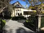
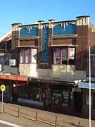
A village commercial area exists on Rochester Street, near the station and opposite Homebush Public School. The commercial buildings along the village high street are largely preserved from the 19th century and are protected as a heritage conservation area. These shops extend to The Crescent, opposite Homebush railway station.[10]
Significant parts of the former Village of Homebush are protected as heritage conservation areas, including almost the entirety of Abbotsford Road, which runs east-west across most of the Village, as well as parts of Meredith Street and a large part of the Rochester Street village commercial area.
Because the southern part of the village of Homebush is now administratively part of the suburb of Strathfield, various sites previously identified with Homebush are no longer within the boundaries of the suburb. These include the Homebush War Memorial in Davey Square, at the southern tip of the village of Homebush.
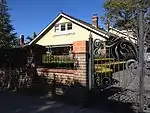
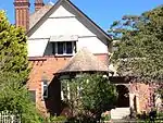
Notable or heritage listed houses in the Village of Homebush estate
- Billesdon was built in 1915 for Stephen Rabone to a design by Rupert Minnett.[11]
- Broughlea was built c. 1881 for Horatio Aylward, a solicitor in the firm of Aylward and Wild.[12]
- Camden Lodge was built c. 1917 for Robert Trevethan.[13]
- Dunkeld (now Edensor) was built in 1906 by pastoral agent[14] and tennis player[15] John Peate Duguid (1875-1961).[16] The house was then owned by James Pearce (1857–1916), who was the proprietor of the Strathfield Flour Mills.[17]
- Florenceville was built in the early 1880s by John Shiply.
- Hawthorn was built c. 1886 for Frederick William Binney to a design by Cyril and Arthur Blacket. Binney was Secretary of the Newcastle-Wallsend Coal Company and the Northern Collieries Association.[18]
- Ingera (now Inglemere and trading as Darcy's Hotel) was built c. 1894 for William Norton.[19]
- Rothsay was built c. 1884 for Samuel Thompson (1821–1910), who was a stockbroker.
- Warwick was built in the early 1890s in the late Victorian style. It became known as Warwick in 1902 when it was bought by public subscription for Emily Forrester (1842–1917), widow of William Forrester (1842–1901) who had owned Warwick Farm as a private racecourse before he died owning nothing. The Forrester Fund raised £1387 and its committee paid £800 for the Homebush house.[20] Emily Forrester died at Warwick, Homebush, in 1917.[21]
North Homebush

The part of Homebush north of the railway was developed slightly later. This area is bisected by Parramatta Road and the M4 Western Motorway. Although Edward Powell's Half Way House Inn on Parramatta Road had been established early in the life of the colony, the rest of the area was largely used for grazing. In the 1870s, stockyards (for the sale of livestock by auction) were erected adjacent to the station. In 1881, an attempt was made to subdivide the part of the former Home Bush Estate north of Parramatta Road, as the "Homebush Park Estate".[22] However, this and subsequent subdivision proposals were not successful, and other than the lots adjacent to Parramatta Road, most of the land remained unsold and was sparsely populated.[23]
When the NSW Government abattoirs were moved from Glebe to present-day Sydney Olympic Park, the stockyards were closed and replaced by Flemington stockyards, further west, in 1883.[24] Hotels and other businesses were established in the area adjacent to the stockyards, servicing stockyard and abattoir workers.[25]
The removal of the stockyards allowed development of North Homebush to begin, around the turn of the 20th century, with its own local government (the Municipality of Homebush) established in 1906. The area immediately around Parramatta Road became a busy commercial area, serving workers at factories located along Parramatta Road and further to the north, such as the Arnott's Biscuits factory and the EMI records factory, established in the early 20th century.[25] This area was centred on the intersection of Knight Street with Parramatta Road.
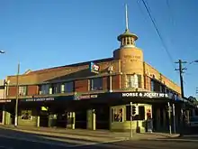
However, with the decline of industry and the increase of traffic congestion along Parramatta Road after World War II, most of these are now shut or abandoned, similarly to other parts of Parramatta Road.[25] Some remnants of the former commercial area remain, including the Horse and Jockey Hotel, a heritage-listed pub on the site of the original Half Way House Inn, as well as the imposing former Homebush Cinema, now abandoned.[26] At least for the time being car sales yards continue to flourish along Parramatta Road but this main artery through North Homebush has now been re-zoned high density residential, with mid- and high-rise apartment blocks proliferating. The one commercial area along Parramatta Road which remains thriving is in the extreme west of this part of the suburb. It is part of Sydney Markets Plaza and serves the Sydney Markets at Flemington.
North of the M4 Western Motorway, the suburb boundaries extend further west to the western bank of Saleyards Creek. A large portion of this area is occupied by former industrial land, now redeveloped into parklands, office parks and the Direct Factory Outlet shopping centre.
As a postal town (for Australia Post purposes) the name "Homebush" refers only to North Homebush.[27] North Homebush has a population of 5797.[28][29]
Heritage listings
Homebush has a number of heritage-listed sites. This includes the following state heritage listed site:
- Great Southern and Western railway: Homebush railway station.[24]
Governance
Strathfield Council, as proclaimed in 1885, included the then-village of Homebush, which included the southern part of modern-day Homebush, south of the railway and the northwestern part of modern-day Strathfield. The part of the modern suburb north of the railway remained unincorporated until Homebush Municipality was established in 1906. Homebush Municipality operated until 1947, when it was amalgamated with Strathfield Municipality.
Transport
Homebush railway station is serviced by all stations services on the Inner West & Leppington Line of the Sydney Trains network. Parramatta Road and the M4 Western Motorway are the main arterial roads passing through the suburb.
Schools
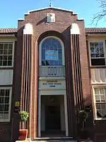
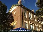
- Homebush Public School, a government primary school, was established in 1885 on its present site between The Crescent, Rochester Street and Burlington Road. Brick buildings were originally built facing The Crescent in 1897 and Burlington Road in 1916.
- Homebush Boys High School was founded in 1936 and is a comprehensive public high school for boys. Formerly a selective high school until the 1970s, Homebush Boys was regarded as one of the academically best-performing comprehensive schools, and has, in the past, been ranked above selective schools on the Higher School Certificate results.[30] The school has an enrolment of approximately 1200 students and the students and staff are from diverse backgrounds and many of them live outside the area.
Population
At the 2016 census, there were 7,007 residents in Homebush. 30.5% of people were born in Australia. The next most common countries of birth were India 16.4%, China 10.5%, South Korea 8.9%, Sri Lanka 5.4% and Nepal 3.4%. The top responses for ancestry were Chinese (16.8%), Indian (15.7%), Korean (9.0%), English (8.4%) and Australian (7.0%). 26.6% of people only spoke English at home. Other languages spoken at home included Mandarin 10.7%, Korean 10.2%, Tamil 9.8%, Cantonese 5.3% and Hindi 4.2%. The most common responses for religion were No Religion 24.3%, Hinduism 23.4% and Catholic 18.4%.[1]
Residents
The following were either born or have lived at some time in the suburb of Homebush:
- Billy Hughes, Prime Minister of Australia
- May Hollinworth, theatre producer and director
- Thomas Keneally, author of Homebush Boy: A Memoir (1995)
- Fenella Kernebone, arts presenter
- Rosa Angela Kirkcaldie, hospital matron and army nurse [31]
- Chris Lang, politician
- Evan Mander-Jones, educator and United Nations official [32]
- Phyllis Mander-Jones, librarian
- Charles Meredith, colonial politician in Tasmania
- Warren R Rodwell, former soldier, university teacher, hostage survivor [33] and lyricist [34]
- D'Arcy Wentworth, surgeon
Gallery
 Shops, The Crescent
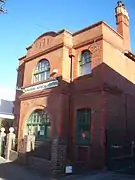 Former Homebush Post Office, The Crescent
References
- Australian Bureau of Statistics (27 June 2017). "Homebush (NSW) (State Suburb)". 2016 Census QuickStats. Retrieved 21 December 2017.

- "Liberty Plains". The Dictionary of Sydney. Retrieved 28 June 2018.
- "Edward Powell". Monument Australia. Retrieved 28 June 2018.
- Jones, Michael (1985). Oasis in the West: Strathfield's first hundred years. North Sydney: Allen & Unwin Australia. ISBN 0-86861-407-6 (page 15)
- pers. comm. 2014 to John Byrnes, for the "Homebush Project" Archived 6 March 2016 at the Wayback Machine
- Strathfield Heritage - Directories
- Australia Post - Homebush South
- Homebush (South) - About the profile areas
- Village of Homebush Walking Tour Archived 17 December 2014 at the Wayback Machine Retrieved 7 August 2013.
- Strathfield Council - Homebush Village shopping centre
- Strathfield History Images Archived 17 December 2014 at the Wayback Machine Retrieved 7 August 2013.
- Broughlea Retrieved 7 August 2013.
- Jones, Cathy. "Camden Lodge". Strathfield Heritage Website. Retrieved 13 May 2014.
- Index to The Historian – Ku-ring-gai Historical Society Retrieved 27 December 2019.
- "TENNIS TALK". The Arrow. New South Wales, Australia. 5 September 1908. p. 12. Retrieved 27 December 2019 – via Trove.
- STATEMENT OF HERITAGE IMPACT 17 Meredith Street, Homebush Retrieved 27 December 2019.
- "Family Notices". The Leader. Orange, NSW: National Library of Australia. 7 June 1916. p. 5. Retrieved 7 August 2013.
- Hawthorne Retrieved 7 August 2013.
- Inglemere Retrieved 7 August 2013.
- "SPORTING". The Evening News. Sydney: National Library of Australia. 16 May 1902. p. 2. Retrieved 7 August 2013.
- "Family Notices". The Sydney Morning Herald. National Library of Australia. 2 July 1917. p. 6. Retrieved 7 August 2013.
- City of Parramatta - Wentworth Point - A Brief History
- Site 2 – Sydney Olympic Park: Historical Archaeological Assessment and Statement of Heritage Impact
- "Homebush Railway Station group". New South Wales State Heritage Register. Office of Environment and Heritage. H01170. Retrieved 2 June 2018.
- Homebush North Shops
- Strathfield Heritage - Homebush Cinema
- Australia Post - Homebush
- About the Profile Area - Homebush (North)
- About the Profile Area - Homebush (Central)
- Board of Studies 2006 ‘HSC Report – Top schools in each region’, The Board of Studies, 23 December 2006.
- "Kirkcaldie, Rosa Angela (1887–1972)". Australian Dictionary of Biography.
- "Mander-Jones, Evan (1902–1975)". Australian Dictionary of Biography.
- 472 Days Captive of the Abu Sayyaf The Survival of Australian Warren Rodwell
- Abducted but not by Mad Cowboy Disease
External links
| Wikimedia Commons has media related to Homebush, New South Wales. |