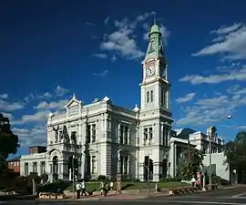
Inner West
The Inner West of Sydney is an area directly west of the Sydney central business district, New South Wales, Australia. The suburbs that make up the Inner West are predominantly located along the southern shore of Port Jackson (Parramatta River), stretching south to the shores of the Cooks River. The western boundary of the Inner West is approximately the A3 arterial road (Homebush Bay Drive / Centenary Drive), which divides the Inner West from the Greater Western Sydney region. The Inner West is much larger than the Inner West Council local government area. The Inner West roughly corresponds with the Parish of Petersham and Parish of Concord, two cadastral divisions used for land titles.
| Inner West Sydney New South Wales | |||||||||||||||
|---|---|---|---|---|---|---|---|---|---|---|---|---|---|---|---|
 | |||||||||||||||
| Population | 293,301 (2016 census)[1] | ||||||||||||||
| LGA(s) | |||||||||||||||
| State electorate(s) | |||||||||||||||
| Federal Division(s) | |||||||||||||||
| |||||||||||||||
Suburbs
The boundaries of the Inner West region are customary, not administrative or legal, and as such are defined differently in different contexts. The northern and southern boundaries are natural and thus generally well defined: they are the Parramatta River and the Cooks River respectively. In the west, the upper reaches of the Cooks River flow close to, but do not meet, the Parramatta River, and the western boundary is thus ill-defined. However, in many contexts this boundary is defined as the A3 arterial road (Homebush Bay Drive / Centenary Drive), which runs north-south close to the source of the Cooks River and the point at which the two rivers run closest to each other. The area immediately to the west of the A3 near the source of the Cooks River is largely occupied by Rookwood Cemetery, Sydney Olympic Park and other parkland, railways and industrial land, and so forms a convenient and well defined dividing strip between the Inner West and the Greater Western Sydney region. The eastern boundary is less well defined, as many suburbs immediately to the west of the Sydney city centre are alternatively regarded as part of the Inner West or as part of the City or "inner city" region. Customarily, either the A36 arterial road (Princes Highway/King Street/City Road) or the local arterial route formed by Sydney Park Road, Mitchell Road, Gibbon Street/Botany Road and Regent Street is often seen as the boundary between the Inner West and the inner city/Eastern Suburbs/inner south region.
The Inner West is alternatively defined as corresponding to the Parish of Petersham and Parish of Concord, two cadastral divisions used for land titles. This largely agrees with the customary definition above, except for some suburbs immediately to the east or west of the cadastral boundaries. For example, the western boundary of the Parish of Concord follows the course of a creek that approximates the boundary between Homebush and Homebush West. The parish therefore excludes Homebush West even though that suburbs lies mostly east of the A3 road. Conversely, the suburb of Rhodes is mostly west of the A3 road but in the Parish of Concord. On the eastern side, Erskineville and Macdonaldtown and Darlington are within the Parish of Petersham, but most of neighbouring Redfern and Alexandria are not.
The Australian Bureau of Statistics also defines a statistical region (Statistical Area Level 4) called "Inner West". This region comprises most of the Municipality of Strathfield, Municipality of Burwood and the City of Canada Bay, as well as the former Municipality of Ashfield and Municipality of Leichhardt (both now part of Inner West Council).[2] This region is mostly a subset of the regions in the two definitions outlined above, excluding the inner western and inner southwestern suburbs such as Glebe, Enmore, Petersham and Marrickville, which are instead in the region called "City and Inner South". As it is based on suburb boundaries, it also includes some small areas that fall outside the definitions outlined above, such as the part of the suburb of Strathfield South that lies south of the Cooks River and the parts of several suburbs that lie west of the A3 road.[3]
Another customary definition of the Inner West is by local government areas. In this customary definition, the Inner West Council, City of Canada Bay, the Municipality of Strathfield and the Municipality of Burwood make up the Inner West. This definition is sometimes used in local government administrative contexts.[4] This definition excludes the inner-most suburbs that are within the City of Sydney council area and southern suburbs that are within the City of Canterbury-Bankstown, but includes some suburbs that lie outside the above definitions but are within the Municipality of Strathfield.
Commercial sources, especially in the real estate context, sometimes refer to suburbs that are not in any of the definitions above as being in the Inner West. For example, Beaconsfield is variously considered part of inner city, Eastern Suburbs[5] or inner south Sydney, but is also sometimes referred as part of the Inner West.[6] Likewise, Wentworth Point is part of Greater Western Sydney by any of the above definitions, separated from the Inner West by Sydney Olympic Park and the waters of Homebush Bay, and is normally considered part of that region in administrative contexts,[7] but is sometimes referred to as part of the Inner West.[8]
Based on the above definitions and the former distribution area of the Inner West Courier local newspaper,[9] the Inner West generally includes the suburbs:
|
|
|
|
|
|
|
Other suburbs sometimes referred to as being in the Inner West, especially in commercial contexts, include:
History
Indigenous land
Prior to the arrival of the First Fleet, the Sydney region was home to the Darug people. This nation was broken up into a number of Aboriginal clans who tended to live in a certain geographic area. Each clan contained about 50 to 100 people and, to avoid genetic problems, the men would marry women from other clans. So the clans were interrelated and members from one clan would frequently travel in the territory of others, including to hunt, trade and perform ceremonies. They didn't consider themselves owners of the land, rather custodians.[12]
What is now the Inner West was formerly home to two clans, the Cadigal, whose land stretched along Port Jackson from South Head to Lewisham, and the Wangal, whose land was immediately to the west of the Cadigals and stretched to about Homebush Bay. Other clans that would have been regular visitors to the area would have included the Birrabirragal and Muru-ora-dial in what is now the Eastern Suburbs, the Bediagal and Kameygal from the Cooks River area to the south, the Burramattagal from the Parramatta area to the west, and the Wallumattagal, Cammeraigal and Gorualgal from the northern shores of the Parramatta River.[13]
European arrival

.jpg.webp)
Land grants in the Inner West area began in the late 18th century. By 1814, a stage coach was running between the two major settlements of Sydney (to the east) and Parramatta (to the west), then further west to Richmond. This spurred the development of several settlements along the stage coach route, now Parramatta Road. A number of the large land grants in the area were subdivided for commercial and residential development, such as Ashfield Park in 1838. The construction of the Main Suburban railway line in 1855 spurred further development, especially at the original stations of Newtown, Ashfield, Burwood and Homebush. Many of the original land grants in the area were subdivided for commercial and residential development in the decades following the arrival of the railway, such as the Village of Homebush in 1878. The colony's elite - politicians, judges, industrialists and businessmen - began to build grand homes in the "outer" parts of the Inner West, such as the Arnott family (of the biscuit empire) and the family of David Jones (the retailer), who built various homes in Strathfield.
As a result of population growth, local governments formed in the area in the 19th century, such as the Municipality of Newtown in 1862, the Municipality of Petersham, the Municipality of Leichhardt and the Municipality of Ashfield in 1871, the Municipality of Burwood in 1874, the Municipality of Concord in 1883 and the Municipality of Strathfield in 1885.
During the last quarter of the 19th century, Sydney's tram network expanded into the Inner West, and continued expanding into the early 20th century, eventually serving almost all of the Inner West, as far afield as Cabarita, Enfield and Canterbury.
In 1895, a suburban railway line was built, branching from the Illawarra Line at Sydenham, which provided access to the railway for suburbs in the south of the Inner West, such as Marrickville and Dulwich Hill.
Industrial and residential development
.jpg.webp)
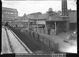
Due to its central location and easy access by water, rail and road, large scale industrial development occurred in the Inner West in the late 19th and early 20th centuries. A number of large residences were turned to industrial use, such as Arthur Renwick's Abbotsford House, which became Nestlé's chocolate factory, and Roland Ducker's Strathroy in Cabarita, which became the paint factory of British Australian Lead Manufacturers (BALM), later Dulux.[14]
However, the residential suburbs continued to be popular. For example, Australian prime ministers who lived in the Inner West in this period include William McMahon, Earle Page, George Reid, Frank Forde and Billy Hughes. A number of the high quality residential developments in the period immediately after the Federation of Australia are highly regarded ensembles of Australian residential architecture and heritage protected, including the large scale Haberfield "garden suburb" development, which began in 1901, the smaller Malvern Hill Estate in Croydon, which began in 1909, and the Hoskins Estate in Appian Way, Burwood, which began in 1903.
Suburbanisation accelerated in the interwar years, resulting in the outer suburbs of the Inner West, such as Strathfield, Burwood and Concord, growing in prestige while the dense inner suburbs, such as Newtown, Enmore and Erskinville, declined.
Post-war migration and gentrification

An influx of migrants to Australia following the end of World War II brought a large number of migrants to the Inner West, primarily from European countries. Many migrants were attracted to the area by the availability of industrial jobs, proximity to the City and the good availability of public transport. The change in demographics also brought ethnically distinct shops, cafes and restaurants, giving a cosmopolitan character to the commercial areas of a number of commercial centres in the Inner West. For example, Haberfield and Leichhardt became distinguished by the concentration of Italian businesses, while Petersham became the hub of Sydney's Portuguese community.
Continued industrial development and the influx of blue collar workers, including European immigrants, accelerated the disparity between suburbs. In 1977, Strathfield was the most expensive suburb in metropolitan Sydney measured by median house price, while inner suburbs of the Inner West, such as Leichardt, were cheaper than outer Western suburbs such as Bankstown.[15]
The pattern of immigrant settlement continued and radiated further west after the end of the White Australia Policy changed the ethnic makeup of Australia's migrant intake. For example, in the late 20th century, Ashfield became a hub for Chinese immigrants, especially those from Shanghai, known as "Little Shanghai". Burwood has likewise become a hub for Chinese immigrants and overseas students.
Towards the end of the 20th century, the proliferation of alternative cultures in the inner suburbs such as Newtown led to a wave of gentrification.[16][17]
Along the foreshore and in the outer suburbs of the Inner West, industrial facilities were returned to residential use. The Colgate-Palmolive factory and the Lever Brothers soap factory, both in Balmain, were converted into apartments. Both Abbotsford House and Strathroy House, mentioned above, were restored and returned to residential use, while the factories that were built around them were replaced by upmarket housing developments. Likewise, the flour mills which have long dominated the skyline of Summer Hill was redeveloped for residential use.[18]
Geography
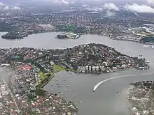
The geography of the Inner West is defined by the southern catchments of the Parramatta River, the northern boundary of the region, and the northern catchment of the Cooks River, the southern boundary. The western boundary of the region is near the source of the Cooks River. The Hume Highway approximately follows the ridgeline between the two catchments.
In this region, Parramatta River widens via a series of bays and transitions into the drowned valley that forms Sydney Harbour. This forms a series of large bays along the southern shore, the largest of these being (from west to east) Homebush Bay, Hen and Chicken Bay and Iron Cove. The presence of these bays have had a significant effect on patterns of development in the region and the placement of infrastructure such as roads and railways.
In between the two rivers, the topography is characterised by rolling hills intersected by shallow valleys through which waterways flow to the two rivers, including Iron Cove Creek, Hawthorne Canal (formerly Long Cove Creek), Whites Creek and Johnstons Creek. These waterways have been drastically altered since the late 19th century by the means of concrete lining. In the 1860s iron Cove Creek was a freely flowing waterway which in places broadened into ponds that made excellent and picturesque swimming holes. It is now barely a trickle lined by residential areas, parkland and fast-food restaurants.
Housing
The housing stock within the Inner West reflects the distinct waves of development in its history. The inner-most suburbs of the Inner West were developed early in the life of the colony, and preserve stone houses from the Victorian era and earlier. The inner suburbs of the Innwer West were largely subdivided in the 19th century for suburban development, and a large number of two-storey terraced houses and one-storey terraced and timber cottages survive in suburbs such as Glebe, Newtown and Annandale. Further away from the City, a large number of grand houses of the Victorian era are stills standing, though many have been subdivided or are no longer in residential use. After these suburbs were subdivided around the turn of the 20th century, Federation architecture dominated the style of suburban houses, simplifying over time to the Australian Californian bungalow style which is still found throughout most of the inner west. While many of the older houses have been replaced by new constructions, a number of areas have retained contiguous areas of housing stock from the early 20th century or earlier, and a number of heritage conservation zones have been created to preserve the character of these areas.
During the 20th century, low- to medium-rise apartment blocks began to proliferate, especially along the railway line. These have in turn been succeeded by the construction of medium- to high-rise apartment blocks in the late 20th century, especially around major stations such as Strathfield and Burwood, and in the redevelopment of formerly industrial land throughout the region and especially along the Parramatta River waterfront. Nevertheless, government planning controls seek to preserve the low-density residential land use throughout much of the Inner West.
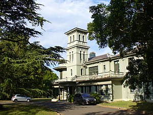 Yaralla, in Concord West, built in the 1860s.
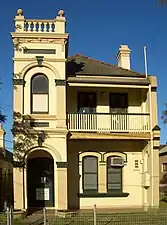 A Victorian-style house in Marrickville.
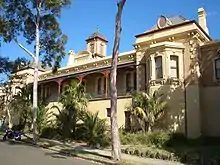
 Cassa Tasso, an example of Federation-era suburban residential architecture in the Hoskins Estate on Appian Way, Burwood.
Quiroma_in_ABeckett_Avenue.jpg.webp) Federation bungalow house in Ashfield
Federation bungalow house in Ashfield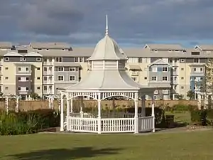 Breakfast Point, a large scale development on former industrial land.
Schools

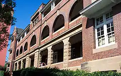
The Inner West is the location of several tertiary institutions such as the University of Sydney at the eastern end in Camperdown, and a major campus of the Australian Catholic University and the Catholic Institute of Sydney at the western end in Strathfield. A relatively high proportion of the population consists of tertiary students, both in the areas around these institutions, and in the suburbs further away that are well connected to educational institutions by public transport.
The Inner West has a high concentration of public and private secondary schools, many of which were established in the 19th century. Government high schools located in the Inner West include the selective secondary schools Fort Street High School and Sydney Secondary College, and the public comprehensive high schools Burwood Girls High School, Homebush Boys High School, Strathfield Girls High School and Ashfield Boys High School. Government schools with a selective stream, without being completely selective schools, also exist (such as Alexandria Park Community School). Private schools in the Inner West include the Presbyterian Ladies' College in Croydon, Meriden School, St. Patrick's College and Santa Sabina College all in Strathfield, MLC School in Burwood, Trinity Grammar School in Summer Hill (preparatory school in Strathfield), Newington College in Stanmore and Rosebank College in Five Dock.
Transport
Public transport in the region includes trains, buses, ferries and light rail.[19]
A number of Sydney Trains commuter rail services run along the Main Suburban railway line from Central station to Strathfield, largely running south of Parramatta Road. From Strathfield, these lines proceed in different directions, including the Inner West & Leppington Line which proceeds to Macarthur via Granville, the Northern Line which branches off at Strathfield to the north towards Epping, and the North Shore & Western Line which proceeds towards Emu Plains or Richmond via Parramatta. The separate Bankstown Line follows a more southerly alignment, and provides train services to suburbs such as Erskineville, St Peters, Sydenham, Marrickville and Dulwich Hill.
There are various bus routes provided largely by State Transit and Transit Systems.
Sydney Ferries operates services in the inner harbour and Parramatta River, with a number of wharves serving suburbs in the northern part of the Inner West.
The Dulwich Hill Line of Sydney's light rail network connects to Central to the Inner West via Pyrmont, with stops in Glebe, Lilyfield, Leichhardt, Lewisham and Dulwich Hill, where it connects to the Bankstown railway line.
Parramatta Road is a major arterial road that runs through the middle of the Inner West, connecting it with the major centres of Sydney City in the east and Parramatta in the west. At Summer Hill, Liverpool Road (the Hume Highway) branches from Parramatta Road and proceeds in a southwesterly direction towards Melbourne. The M4 road largely runs as a motorway tunnel under the western part of the Inner West, parallel to Parramatta Road. At the eastern end of the tunnel in Ashfield, it branches north to become the A4 road which runs to the Sydney CBD, while another branch joins Parramatta Road. The ongoing WestConnex project will eventually extend the tunnel further east to bypass the surface road section of the A4 and also to connect with the M8 motorway.
Although still playing only a small part in the overall transport task, use of bicycles for transport has increased significantly in the Inner West since the 1990s. Denser populations and shorter distances mean cycling is often quicker and more convenient than driving or taking public transport. A network of bicycle paths, signed bicycle routes on local streets and other aids to safe and convenient cycling is developing. Main bicycle routes include two north-south routes: one located in the western part of the Inner West called the Cooks River cycleway or "Bay to Bay" cycleway, which connects Ryde to the north with the Cooks River valley and Botany Bay to the southeast, and another located further east called the Greenway which connects Iron Cove in the north to the Cooks River valley where it joins the Cooks River cycleway, an east-west route from Five Dock to the Anzac Bridge cycleway, a northwest route from Gladesville Bridge to Anzac Bridge, and a southwest Route from Marrickville to the City via Newtown. Groups of local bicycle user groups (BUGs) provide help for new cyclists, under the parent banner of Bicycle New South Wales.[20]
Government
In the state parliament, the region is represented by the electoral districts of Balmain, Canterbury, Drummoyne, Newtown, Strathfield and Summer Hill. Following the 2015 state election, these seats were divided amongst the three main parties with Drummoyne represented by the Liberal Party, Canterbury, Strathfield and Summer Hill represented by the Australian Labor Party, and Balmain and Newtown represented by The Greens.[21]
In the federal parliament, the area is represented by the electorate of Grayndler and part of the electorates of Reid, Sydney and Watson (which also encompasses a substantial section of the Canterbury-Bankstown area). Three of these four seats are currently held by the Labor Party, with the seat of Reid represented by the Liberal Party at the 2013 federal election, which won the seat for the first time in 91 years.[22]
Local Government areas
The Inner West is an imprecise geographical region. The Australian Government Bureau of Statistics,[23] the New South Wales Government Department of Planning and Infrastructure,[24] and local media variously describe the Inner West region to include all (or some) of the following local government areas:
- Municipality of Burwood
- City of Canada Bay
- Inner West Council
- Municipality of Strathfield
- The northeastern part of the City of Canterbury-Bankstown
- The western part of the City of Sydney.
Sport
The Inner West is represented in the National Rugby League by the Wests Tigers, a merger of the Balmain and Western Suburbs clubs. The Region also has another team that represents the region, they're the Canterbury-Bankstown Bulldogs. In the tier below known as the New South Wales Cup, the area is represented by the Newtown Jets and Wests Tigers.
In rugby union, the area is represented by Sydney Uni (the University of Sydney) and West Harbour in the Sydney grade competition.
In soccer football, Leichhardt Oval is the home of the A-league team Sydney FC. The Inner West also has many semi-professional soccer teams playing in the various divisions of the NSW State Leagues. The most high profile club is NSW Premier League side APIA Leichhardt Tigers.
Religion
In the 2016 Census, the most common responses for religion in the Sydney Inner West were No Religion, 31.7%, Catholic 27.4%, Not stated 9.4%, Anglican 6.9% and Hinduism 5.4%.[25]
References
- Australian Bureau of Statistics (27 June 2017). "Sydney - Inner West (SA4)". 2016 Census QuickStats. Retrieved 15 August 2019.

- ABS - Sydney - Inner West (SA4) (120)
- 2016 Census QuickStats - Sydney - Inner West
- See, e.g., Inner West Council, "Inner West Youth Alliance": "... the Sydney Inner West local government areas of the Inner West, Burwood, Canada Bay and Strathfield"
- Domain Suburb Profile - Beaconsfield
- Domain Property Guide 2016
- Centre for Western Sydney - About the profile area
- Domain Property Guide 2016
- "Inner West Courier - Inner West Edition Distribution". NewsLocal (News Corp Australia). Retrieved 11 October 2016.
- https://www.dailytelegraph.com.au/newslocal/inner-west/wentworth-point-rowing-club-to-be-at-the-heart-of-homebush-bay-precinct-development/news-story/63c32e394dce6ab1d7b232d9c47a16bf
- https://www.dailytelegraph.com.au/newslocal/inner-west/wentworth-point-and-rhodes-bridge-to-break-sydneys-dependence-on-cars/news-story/4b82bd7764b02a85c31630fb48f640c2
- Speed the Plough — Ashfield 1788-1988, by Sheena & Robert Coupe, published by Ashfield Municipal Council, 1988 ISBN 0-9595234-1-3
- Archived October 4, 2008, at the Wayback Machine
- Canada Bay Connections
- Domain, What Sydney prices looked like 40 years ago when Bankstown was more expensive than Leichhardt
- Tovey, Josephine. "Bars open, property up: arise the 'new Paddington'". Sydney Morning Herald. Retrieved 15 November 2013.
- Horin, Adele. "Grunge gives way to gentrification in streets of Newtown". Sydney Morning Herald. Retrieved 15 November 2013.
- Munro, Catherine, "Light rail left idling on the track", Sydney Morning Herald, 15 October 2007. Retrieved 15 October 2007.
- "Inner West - Sydney City". Retrieved 14 March 2016.
- Home - Bicycle NSW
- "NSW State Election 2011". Elections NSW. Retrieved 16 October 2011.
- Needham, Kirsty (8 September 2013). "Bloodbath in west just did not happen". The Sydney Morning Herald. Retrieved 8 November 2013.
- "1216.0 NSW statistical divisions, subdivisions, local areas". Australian Bureau of Statistics. Retrieved 30 July 2008.
- "Centres and corridors — Inner West" (PDF). NSW Department of Planning. Archived from the original (PDF) on 19 July 2008. Retrieved 30 July 2008.
- "Sydney - Inner West (SA4)". 2016 Census QuickStats. 12 July 2019. Retrieved 18 September 2019.
External links
 Sydney/Inner West travel guide from Wikivoyage
- Inner West Live - Community Blog by local Inner West people