Hurkett
Hurkett is a dispersed rural community and unincorporated place in the Unorganized part of Thunder Bay District in northwestern Ontario, Canada.[1] It is on Black Bay on the north shore of Lake Superior in geographic Stirling Township,[4] and is on Ontario Highway 582, a short spur off Ontario Highway 17. Hurkett is a designated place served by a local services board,[5] and has a population of 236.[6]
Hurkett | |
|---|---|
Dispersed rural community | |
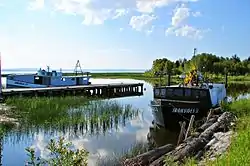 Derelict harbour of Hurkett | |
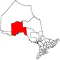
 Hurkett Location of Hurkett in Ontario | |
| Coordinates: 48°50′57″N 88°29′05″W[1] | |
| Country | Canada |
| Province | Ontario |
| District | Thunder Bay |
| Area | |
| • Total | 52.65 km2 (20.33 sq mi) |
| Elevation | 193 m (633 ft) |
| Population (2011)[2] | |
| • Total | 236 |
| • Density | 4.5/km2 (12/sq mi) |
| Time zone | UTC-5 (Eastern Time Zone) |
| • Summer (DST) | UTC-4 (Eastern Time Zone) |
| Postal code | P0T |
| Area code(s) | 807 |
Demographics
Hurkett had a population of 285 in the Canada 2006 Census[7] which declined to 236 in the 2011 census.[6]
| Canada census – Hurkett community profile | |||
|---|---|---|---|
| 2011 | 2006 | ||
| Population: | 236 (-17.2% from 2006) | 285 (% from 2001) | |
| Land area: | 52.65 km2 (20.33 sq mi) | 52.65 km2 (20.33 sq mi) | |
| Population density: | 4.5/km2 (12/sq mi) | 5.4/km2 (14/sq mi) | |
| Median age: | 49.7 (M: 48.2, F: 50.2) | ||
| Total private dwellings: | 121 | ||
| Median household income: | |||
| References: 2011[6] 2006[7] earlier[8] | |||
References
- "Hurkett". Geographical Names Data Base. Natural Resources Canada. Retrieved 2015-07-11.
- "Hurkett, Ontario (Code 350027) census profile". 2011 Census of Population. Statistics Canada. Retrieved 2012-09-24.
- Elevation taken from Google Earth at coordinates given in the Infobox. Accessed 2015-07-12.
- "Stirling" (PDF). Geology Ontario - Historic Claim Maps. Ontario Ministry of Northern Development, Mines and Forestry. Archived from the original (PDF) on 2015-09-24. Retrieved 2015-07-12.
- "Local Services Boards, R.R.O. 1990, Reg. 737". Canadian Legal Information Institute. Retrieved 2015-07-12.
- "2011 Community Profiles". 2011 Canadian Census. Statistics Canada. July 5, 2013. Retrieved 2015-07-12.
- "2006 Community Profiles". 2006 Canadian Census. Statistics Canada. March 30, 2011. Retrieved 2008-08-27.
- "2001 Community Profiles". 2001 Canadian Census. Statistics Canada. February 17, 2012.
Other map sources:
- Map 13 (PDF) (Map). 1 : 1,600,000. Official road map of Ontario. Ministry of Transportation of Ontario. 2014. Retrieved 2015-07-12.
- Restructured municipalities - Ontario map #2 (Map). Restructuring Maps of Ontario. Ontario Ministry of Municipal Affairs and Housing. 2006. Retrieved 2015-07-12.
This article is issued from Wikipedia. The text is licensed under Creative Commons - Attribution - Sharealike. Additional terms may apply for the media files.