Manitouwadge
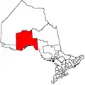
Manitouwadge is a township in the Canadian province of Ontario. It is located in the Thunder Bay District, at the north end of Highway 614, 331 kilometres (206 mi) east of Thunder Bay and 378 kilometres (235 mi) north-west of Sault Ste. Marie.
Manitouwadge
Manidoowaazh | |
|---|---|
| Township of Manitouwadge | |
 | |
 Manitouwadge | |
| Coordinates: 49°08′N 85°50′W | |
| Country | Canada |
| Province | Ontario |
| District | Thunder Bay |
| Settled | after 1953 |
| Incorporated | 1975 |
| Government | |
| • Type | Township |
| • Mayor | John MacEachern[1] |
| • Federal riding | Thunder Bay-Superior North |
| • Provincial riding | Algoma—Manitoulin |
| Area | |
| • Land | 352.07 km2 (135.93 sq mi) |
| Elevation | 332.20 m (1,089.90 ft) |
| Population (2016)[2] | |
| • Total | 1,937 |
| • Density | 5.5/km2 (14/sq mi) |
| Time zone | UTC-5 (EST) |
| • Summer (DST) | UTC-4 (EDT) |
| Postal Code | P0T 2C0 |
| Area code(s) | 807 (826 exchange) |
| Website | www.manitouwadge.ca |
History
Manitouwadge (Manidoowaazh in Ojibwe, meaning "Cave of the Great Spirit") is part of the wide-ranging territory of the Ojibwe people. The town itself was founded by General Engineering Co Limited (later as Noranda and now part of Xstrata) after staking claims in 1953 to support of copper mine.[4] The other mine in Manitouwadge is the Willroy mine, named after two of the "Weekend Prospectors" William Dawidowich and Roy Barker. Full production at Geco and Willroy began in 1957.
From 1954 to 1974 Manitouwadge was classified as an Improvement District. The community became an incorporated township in 1975.
In the early 1980s, gold was discovered at Hemlo,[5] near the intersection of highways 614 and 17, about 50 kilometres (31 mi) south of the town. Noranda acquired the mining rights to a significant portion of the ground in that area, and built the Golden Giant Mine. It offered housing in Manitouwadge to many of the employees of the new mine, and the town boomed.
When the Geco mine closed in 1995, Manitouwadge's population decreased significantly. After peaking at nearly 4000 people in the early 1990s, it decreased to less than 3000 by 2001. With the closing of the Golden Giant Mine in 2006, the population dropped to 2,100 by 2011.[6]
Today
While mining has always been at the forefront of Manitouwadge's economic activity, forestry also plays a significant part in the town's economy. The town is also turning itself into a retirement community, offering some of the lowest housing prices in the country.
Demographics
| Canada census – Manitouwadge community profile | |||
|---|---|---|---|
| 2016 | 2011 | 2006 | |
| Population: | 1,937 (-8.0% from 2011) | 2,105 (-8.5% from 2006) | 2,300 (-22.0% from 2001) |
| Land area: | 352.07 km2 (135.93 sq mi) | 352.06 km2 (135.93 sq mi) | 351.97 km2 (135.90 sq mi) |
| Population density: | 5.5/km2 (14/sq mi) | 6.0/km2 (16/sq mi) | 6.5/km2 (17/sq mi) |
| Median age: | 50.3 (M: 49.5, F: 51.1) | 42.8 (M: 43.4, F: 42.2) | |
| Total private dwellings: | 1,082 | 1,129 | 1,212 |
| Median household income: | $66,048 | $78,894 | |
| References: 2016[7] 2011[6] 2006[8] earlier[9] | |||
| Year | Pop. | ±% |
|---|---|---|
| 1991 | 3,972 | — |
| 1996 | 3,395 | −14.5% |
| 2001 | 2,949 | −13.1% |
| 2006 | 2,300 | −22.0% |
| 2011 | 2,105 | −8.5% |
| 2016 | 1,937 | −8.0% |
| [10][11][2] | ||
Recreation
Currently there are no recreational activities due to coronavirus.
Hiking and skiing
Trails for hiking in the summer and trails for snowmobilers in the winter are also abundant. Ten runs for downhill skiing are present as well as two locations with cross country ski trails managed by the Northern Trails Ski Club. From the top of the ski hill one can see the whole town.
Trivia
- Manitouwadge's municipal limits include four geographic townships: Mapledoram, Leslie, Gemmel, and Gertrude.
- Willroy mine was named after two of the "Weekend Prospectors." William Dawidowich and Roy Barker.
- Manitouwadge was the first Model Town established in Ontario.
- Nearby Mose Lake is named after Moses Fisher, the native guide of James E. Thomson on his 1931 exploration of the Manitouwadge area. Name duplication required the S be dropped.
- From 1954 to 1974 Manitouwadge was classified as an Improvement District. The community attained Township classification in 1975.
- Birthplace of Stanley Cup and Olympic gold medal winning hockey coach Mike Babcock.
Climate
Manitouwadge has a humid continental climate (Dfb) bordering on a subarctic climate (Dfc), typical in Northern Ontario. Summers are generally warm and rainy with cool nights. Winters are typically very cold and very snowy. Winter usually begins late October and lasts into April.
| Climate data for Manitouwadge | |||||||||||||
|---|---|---|---|---|---|---|---|---|---|---|---|---|---|
| Month | Jan | Feb | Mar | Apr | May | Jun | Jul | Aug | Sep | Oct | Nov | Dec | Year |
| Record high °C (°F) | 5 (41) |
8.9 (48.0) |
19 (66) |
28.5 (83.3) |
35 (95) |
39 (102) |
39.4 (102.9) |
34 (93) |
30.6 (87.1) |
25 (77) |
18.3 (64.9) |
12.5 (54.5) |
39.4 (102.9) |
| Average high °C (°F) | −11.4 (11.5) |
−8.3 (17.1) |
−1.1 (30.0) |
7.6 (45.7) |
16.4 (61.5) |
21.2 (70.2) |
23.9 (75.0) |
22.2 (72.0) |
15.1 (59.2) |
7.7 (45.9) |
−0.7 (30.7) |
−8.5 (16.7) |
7 (45) |
| Daily mean °C (°F) | −17.1 (1.2) |
−14.5 (5.9) |
−7.5 (18.5) |
1.3 (34.3) |
9.7 (49.5) |
14.6 (58.3) |
17.5 (63.5) |
16.2 (61.2) |
10.2 (50.4) |
3.9 (39.0) |
−4.2 (24.4) |
−13.4 (7.9) |
1.4 (34.5) |
| Average low °C (°F) | −22.8 (−9.0) |
−20.7 (−5.3) |
−13.9 (7.0) |
−5 (23) |
2.9 (37.2) |
8 (46) |
11.1 (52.0) |
10.2 (50.4) |
5.3 (41.5) |
0 (32) |
−7.7 (18.1) |
−18.2 (−0.8) |
−4.2 (24.4) |
| Record low °C (°F) | −45 (−49) |
−42.2 (−44.0) |
−37.5 (−35.5) |
−30 (−22) |
−13.3 (8.1) |
−2.8 (27.0) |
−1.1 (30.0) |
−1.1 (30.0) |
−6.1 (21.0) |
−14.5 (5.9) |
−33.9 (−29.0) |
−38.9 (−38.0) |
−45 (−49) |
| Average precipitation mm (inches) | 64.4 (2.54) |
43.7 (1.72) |
48.5 (1.91) |
44 (1.7) |
66.4 (2.61) |
80.8 (3.18) |
107.4 (4.23) |
81.9 (3.22) |
104.1 (4.10) |
81.3 (3.20) |
73.5 (2.89) |
63.2 (2.49) |
859.2 (33.83) |
| Average rainfall mm (inches) | 0.2 (0.01) |
2.1 (0.08) |
9 (0.4) |
26.5 (1.04) |
62.6 (2.46) |
80.8 (3.18) |
107.4 (4.23) |
81.9 (3.22) |
101.9 (4.01) |
66.6 (2.62) |
22.1 (0.87) |
2.6 (0.10) |
563.6 (22.19) |
| Average snowfall cm (inches) | 64.2 (25.3) |
41.6 (16.4) |
39.5 (15.6) |
17.4 (6.9) |
3.9 (1.5) |
0 (0) |
0 (0) |
0 (0) |
2.2 (0.9) |
14.7 (5.8) |
51.5 (20.3) |
60.6 (23.9) |
295.6 (116.4) |
| Source: Environment Canada[3] | |||||||||||||
References
- https://www.manitouwadge.ca/government/township-municipal-office/council/
- "Census Profile, 2016 Census: Manitouwadge, Township". Statistics Canada. Retrieved 13 July 2019.
- Environment Canada — Canadian Climate Normals 1971–2000, accessed 21 April 2011
- https://www.thecanadianencyclopedia.ca/en/article/manitouwadge
- Barnes, Michael (1995). Gold in Ontario. Erin: The Boston Mills Press. pp. 91–94. ISBN 155046146X.
- "2011 Community Profiles". 2011 Canadian Census. Statistics Canada. 5 July 2013. Retrieved 29 March 2012.
- "2016 Community Profiles". 2016 Canadian Census. Statistics Canada. 21 February 2017. Retrieved 13 July 2019.
- "2006 Community Profiles". 2006 Canadian Census. Statistics Canada. 30 March 2011. Retrieved 21 April 2011.
- "2001 Community Profiles". 2001 Canadian Census. Statistics Canada. 17 February 2012.
- Statistics Canada: 1996, 2001, 2006, 2011 census
- "Manitouwadge census profile". 2011 Census of Population. Statistics Canada. Retrieved 29 March 2012.
External links
- Township of Manitouwadge
- Manitouwadge Public Library
- Manitouwadge General Hospital
- Manitouwadge – Play In the Extreme
- Manitouwadge and area Local DAILY newspaper OntarioNewsNorth.com
- Education links
Places adjacent to Manitouwadge | |
|---|---|