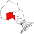
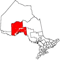
Unorganized Thunder Bay District
Unorganized Thunder Bay District is an unorganized area in northwestern Ontario, Canada in Thunder Bay District. It comprises all parts of the district that are not part of an incorporated municipality or a First Nations reserve.
Unorganized Thunder Bay | |
|---|---|
| Thunder Bay, Unorganized | |
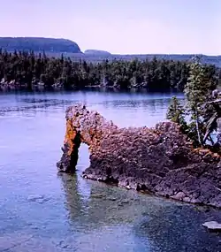 Sleeping Giant Provincial Park | |
 | |
| Coordinates: 50°00′N 88°00′W | |
| Country | |
| Province | |
| District | Thunder Bay |
| Government | |
| • Federal riding | Algoma—Manitoulin—Kapuskasing Kenora Thunder Bay—Rainy River Thunder Bay—Superior North |
| • Prov. riding | Algoma—Manitoulin Kenora—Rainy River Thunder Bay—Atikokan Thunder Bay—Superior North |
| Area | |
| • Land | 97,007.34 km2 (37,454.74 sq mi) |
| Population (2011)[1] | |
| • Total | 5,909 |
| • Density | 0.1/km2 (0.3/sq mi) |
| Time zones | |
| East of 90° west | UTC-05:00 (Eastern) |
| • Summer (DST) | UTC-04:00 (EDT) |
| West of 90° west | UTC-06:00 (Central) |
| • Summer (DST) | UTC-05:00 (CDT) |
| Postal Code FSA | P0T |
| Area code(s) | 807 |
Most of the territory is within the Eastern Time Zone, but the part west of the 90th meridian is in the Central Time Zone.
Local service boards
Other communities
- Auden
- Burchell Lake
- Collins
- English River (on boundary with Kenora District)
- Finmark
- Flindt Landing
- Harvey
- Hemlo
- Kashabowie
- Melgund
- Nolalu
- Ombabika
- Pays Plat
- Raith
- Savant Lake
- Shabaqua
- Shabaqua Corners
- Silver Islet
- Silver Mountain
- Staunton
- Sorrell Lake
- Suomi
- Upsala
Demographics
| Canada census – Thunder Bay, Unorganized community profile | |||
|---|---|---|---|
| 2011 | 2006 | ||
| Population: | 5909 (-10.3% from 2006) | 6585 (5.8% from 2001) | |
| Land area: | 97,007.34 km2 (37,454.74 sq mi) | 97,000.41 km2 (37,452.07 sq mi) | |
| Population density: | 0.1/km2 (0.26/sq mi) | 0.1/km2 (0.26/sq mi) | |
| Median age: | 44.7 (M: 45.2, F: 44.1) | ||
| Total private dwellings: | 5782 | 6655 | |
| Median household income: | $59,153 | ||
| References: 2011[2] 2006[3] earlier[4] | |||
Population trend:[5]
- Population in 2011: 5909
- Population in 2006: 6585
- Population in 2001: 6223
- Population in 1996: 8460 (or 6534 when adjusted to 2001 boundaries)
- Land area: 105,454.69 square kilometres (40,716.28 sq mi)
- Population in 1991: 8168
Parks in Unorganized Thunder Bay
Provincial parks in Unorganized Thunder Bay include:
- Albany River Provincial Park
- Kopka River Provincial Park
- Neys Provincial Park
- Rainbow Falls Provincial Park
- Sleeping Giant Provincial Park
- Steel River Provincial Park
- Wabakimi Provincial Park
It is also home to one National Park of Canada: Pukaskwa National Park.
History
Gold was noted in the area since 1869, but it wasn't until Peter Moses from Heron Bay, discovered additional gold that prospectors flocked to the area. In 1947, Dr. J. Williams and Moses staked 11 claims, which became the Lake Superior Mining Corporation. However, not much development took place until 1979, when Don and David McKinnon, along with John Larche, staked claims in Hemlo and the Manitouwadge area. The Williams Mine started operation in 1985, and produced 445,320 ounces of gold from a 2.45 meter wide ore body. The Golden Giant Mine produced 446,858 ounces in 1994 from a quartz sericite schist host rock. The David Bell Mines produced 204,251 ounces in 1994. The Hemlo gold mines had produced more than 6,000,000 ounces of gold by 1992.[6]
See also
References
- "Thunder Bay, Unorganized census profile". 2011 Census of Population. Statistics Canada. Retrieved 2012-02-10.
- "2011 Community Profiles". 2011 Canadian Census. Statistics Canada. July 5, 2013. Retrieved 2012-02-10.
- "2006 Community Profiles". 2006 Canadian Census. Statistics Canada. March 30, 2011. Retrieved 2011-04-18.
- "2001 Community Profiles". 2001 Canadian Census. Statistics Canada. February 17, 2012.
- Statistics Canada: 1996, 2001, 2006 census
- Barnes, Michael (1995). Gold in Ontario. Erin: The Boston Mills Press. pp. 91–94. ISBN 155046146X.
Places adjacent to Unorganized Thunder Bay District | |
|---|---|