Oliver Paipoonge
Oliver Paipoonge is a township in the Canadian province of Ontario, located directly west of the city of Thunder Bay. The municipality was formed on January 1, 1998, with the amalgamation of the former Township of Oliver and Township of Paipoonge. It contains several communities within its boundaries, including Baird, Carters Corners, Harstone, Kakabeka Falls, Lee, McCluskeys Corners, Millar, Murillo, Rosslyn, Slate River Valley, Stanley and Twin City. The remainder of the municipality is agricultural or rural.
Oliver Paipoonge | |
|---|---|
| Municipality of Oliver Paipoonge | |
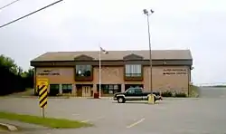 Oliver Paipoonge Municipal Hall | |
 Oliver Paipoonge | |
| Coordinates: 48°23′24″N 89°31′12″W | |
| Country | Canada |
| Province | Ontario |
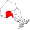
| District | Thunder Bay |
| CMA | Thunder Bay |
| Formed | 1 January 1998 |
| Government | |
| • Mayor | Lucy Kloosterhuis |
| • Federal riding | Thunder Bay—Rainy River |
| • Prov. riding | Thunder Bay—Atikokan |
| Area | |
| • Land | 350.91 km2 (135.49 sq mi) |
| Population (2016)[1] | |
| • Total | 5,922 |
| • Density | 16.9/km2 (44/sq mi) |
| Time zone | UTC-5 (EST) |
| • Summer (DST) | UTC-4 (EDT) |
| Postal code | |
| Area code(s) | 807 |
| Website | www.oliverpaipoonge.ca |
The municipality is part of Thunder Bay's Census Metropolitan Area.
Geography
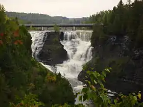
The geography of Oliver Paipoonge transitions from river valleys in the south, through flat open farmland and rolling hills in the central areas, to the rough Canadian Shield in the north. The most notable geographic feature is Kakabeka Falls, located on the western edge of the municipality in Kakabeka Falls Provincial Park.
Communities
Murillo contains a post office, a store, a municipal hall, and a Public Library. New commercial enterprises, located in the Rubin Industrial Park, include a well driller, self-storage facility, a forest products manufacturer, and the Rural Roots child care facility. Each year the village hosts the Murillo Fall Fair, which features chariot races.
The village is the location of the government offices for the Municipality of Oliver Paipoonge as well as the Oliver Paipoonge Police and the Lakehead Rural Planning Board.
Murillo was originally a water stop on the Canadian Pacific Railway (CPR). The stop was named after the Spanish painter Bartolomé Estéban Murillo, as the CPR was at that time using the names of painters to name the many new communities springing up along its trans-Canadian line.[2]
Rosslyn contains numerous commercial enterprises and is home to approximately 1,200 people and the Paipoonge Museum. A golf course and housing subdivision, named King George's Park, are currently being developed in a former gravel pit. There is also a skating rink here, and a community centre and Public Library beside it.
Kakabeka Falls takes its name from the nearby Kakabeka Falls waterfall. The Lauber Arboretum is located in the community.
As Kakabeka Falls' economy is based on tourism, its main street is lined with tourist oriented businesses such as hotels, restaurants, and camping sites. A three-day street fair is hosted in the village every August. Kakabeka Falls has a public school, called Kakabeka Falls Elementary School, located on the community's main street.
Population and demographics
According to the 2016 census, there were 5,922 people residing in Oliver Paipoonge, of whom 51.2% were male and 48.8% were female. Children under five accounted for approximately 5.1% of the resident population of Oliver Paipoonge. This compares with 5.2% in Ontario as a whole.[1]
In mid-2001, 9.7% of the resident population in Oliver Paipoonge were of retirement age (65 and over for males and females) compared with 13.2% in Canada. The average age was 37.9 years of age comparing to 37.6 years of age for all of Canada.[3]
In the five years between 1996 and 2001, the population of Oliver Paipoonge declined by 0.8% compared with an increase of 6.1% for Ontario province as a whole. Population density of Oliver Paipoonge averaged 16.7 people per square kilometre, compared with an average of 12.6 for Ontario altogether.[3]
| Year | Pop. | ±% |
|---|---|---|
| 1996 | 5,907 | — |
| 2001 | 5,862 | −0.8% |
| 2006 | 5,757 | −1.8% |
| 2011 | 5,732 | −0.4% |
| 2016 | 5,922 | +3.3% |
| [4][5][1] | ||
| Canada census – Oliver Paipoonge community profile | |||
|---|---|---|---|
| 2016 | 2011 | ||
| Population: | 5,922 (+3.3% from 2011) | 5,732 (-0.4% from 2006) | |
| Land area: | 350.91 km2 (135.49 sq mi) | 350.96 km2 (135.51 sq mi) | |
| Population density: | 16.9/km2 (44/sq mi) | 16.3/km2 (42/sq mi) | |
| Median age: | 45.4 (M: 45.7, F: 45.0) | 43.8 (M: 44.1, F: 43.5) | |
| Total private dwellings: | 2,289 | 2,149 | |
| Median household income: | $96,981 | ||
| References: 2016[6] 2011[7] earlier[8] | |||
Population prior to amalgamation (1998):
- Population total in 1996: 5,907
- Oliver (township): 2,711
- Paipoonge (township): 3,196
- Population in 1991:
- Oliver (township): 2,462
- Paipoonge (township): 2,972
Transportation
The municipality is served by three major highways. Highways 61 and 130 are located in the southeast corner of the municipality and serves as the backbone of the Slate River Valley, an agricultural community. Highway 130 connects to the Trans-Canada Highway (Highway 11/17) at Rosslyn, the largest settlement. It also serves as the main street for Kakabeka Falls. Approximately half of the population of Oliver Paipoonge lives within five kilometres of Highway 11/17. Highway 102 runs through the northeast corner of the municipality.
A small grass airstrip is located northeast of Kakabeka Falls, and two rail lines run through the municipality.
Economy
Oliver Paipoonge's primary industry is agriculture, followed with tourism focused around Kakabeka Falls and forest products manufacturing in Murillo and Rosslyn. Many residents commute to work either to Thunder Bay or the surrounding woodlands.
Politics
The municipal office of Oliver Paipoonge is located in the village of Murillo. The current mayor of Oliver Paipoonge is Lucia Kloosterhuis; first elected as mayor in 2003, having previously served as a councillor in both Oliver Paipoonge and the former Township of Paipoonge. The first female elected as mayor in Oliver Township was Iris Calvert, in 1991. Previously, the Municipality of Paipoonge had not elected a female as mayor.
Sites of interest
Each year Kakabeka Falls hosts a street fair, Murillo hosts the Murillo Fall Fair, the Slate River area hosts the Slate River Ploughing Match, and the Agriplex hosts an annual summer fair.
There are two museums in the municipality: the Paipoonge Museum in Rosslyn and the Pioneer Museum in the Slate River Valley.
Education
Oliver Paipoonge is served by the Lakehead District School Board. There are four schools located in Oliver Paipoonge, Crestview Public School in Murillo, Kakabeka Falls Public School in Kakabeka Falls, Valley Central Public School and Thunder Bay Christian School (JK - Grade 10). High schools students are bused to Thunder Bay. A daycare centre is located in Murillo.
See also
References
- "Census Profile, 2016 Census: Oliver Paipoonge". Statistics Canada. Retrieved July 12, 2019.
- Tronrud, Thorold J. & Nicholson, David (1999). Thunder Bay Quiz Book: 101 Fascinating Questions about our History Archived 2012-02-07 at the Wayback Machine. Thunder Bay Historical Museum Society, pps. 9 (question) and 36 (answer) ISBN 0-920119-50-6.
- "Oliver Paipoonge community highlights". 2001 Census data. Statistics Canada. Retrieved 2011-04-27.
- Statistics Canada: 1996, 2001, 2006, 2011 census
- "Oliver Paipoonge census profile". 2011 Census of Population. Statistics Canada. Retrieved 2012-03-29.
- "2016 Community Profiles". 2016 Canadian Census. Statistics Canada. February 21, 2017. Retrieved 2019-07-12.
- "2011 Community Profiles". 2011 Canadian Census. Statistics Canada. July 5, 2013. Retrieved 2019-07-12.
- "2001 Community Profiles". 2001 Canadian Census. Statistics Canada. February 17, 2012.
External links
Places adjacent to Oliver Paipoonge | ||||||||||
|---|---|---|---|---|---|---|---|---|---|---|
| ||||||||||