Hyde Park, Cincinnati
Hyde Park is an affluent neighborhood on the east side of Cincinnati, Ohio. The population was 13,356 at the 2010 census.[2]
Hyde Park | |
|---|---|
 Hyde Park Square | |
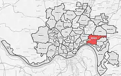 Location within Cincinnati | |
| Country | United States |
| State | Ohio |
| City | Cincinnati |
| Area | |
| • Total | 2.736 sq mi (7.09 km2) |
| Elevation | 660 ft (201 m) |
| Population (2010) | |
| • Total | 13,356[1] |
| Time zone | UTC-5 (EST) |
| • Summer (DST) | UTC-4 (EDT) |
| ZIP code | 45208 |
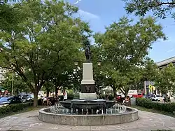
It is located on the eastern side of Cincinnati, approximately six miles away from Downtown Cincinnati. Much of the neighborhood is situated between Interstate 71 and the Ohio River. At the center is Hyde Park Square, which is within a 2-block area of Erie Avenue primarily bounded by Edwards Road on the West and Michigan Avenue on the East. The square features a park in the center surrounded by retail shops and restaurants. Its centerpiece is the Kilgour Fountain, which features a draped female figure with fluted basins. It was donated in 1900 by John and Charles Kilgour. The Graeter's Ice Cream parlor has been present on Hyde Park Square since 1938.[3]
In 2010, Forbes named Hyde Park one of "America's Best Neighborhoods", citing the education levels of its residents and its high concentration of shops and restaurants.[4]
History
Hyde Park initially consisted of a rural area with very few houses as late as 1885, until the Norfolk and Western Railway linked it with Cincinnati in the 1872.[5] Shortly afterwards, population began to increase and in 1892, several prominent Cincinnati real estate businessmen, collectively known as the Mornington syndicate, capitalized on the new transportations to downtown and purchased much of the land to create a community exclusively for Cincinnati's wealthy, selling old parcels to residents who met such criteria.[6][7] In 1896, the village of Hyde Park was incorporated and was named after the affluent hamlet of Hyde Park in New York.
In November 1903, Hyde Park was annexed by the City of Cincinnati.[8][9] Almost immediately thereafter, it experienced a real estate boom, bringing hundreds of new residents. Today, the neighborhood is rather thickly populated.
Geography
Hyde Park is located on the eastern side of Cincinnati, approximately six miles away from the Central Business District. Much of the neighborhood is situated between Interstate 71 and the Ohio River. It is bordered by the neighborhoods of East Walnut Hills, Evanston, Mt. Lookout, O'Bryonville, Oakley, and the City of Norwood.
Hyde Park is located on a plateau above the Ohio River Valley and the Miami Valley. Linwood Road, Torrence Parkway and Delta Avenue, all flow towards the Ohio River and follow the major pathways by the major drainage valleys that cut into the plateau.[10]
Climate
As part of Cincinnati, Hyde Park is in the humid continental climate zone (Köppen: Dfa):
| Climate data for Cincinnati (Cincinnati/Northern Kentucky Int'l), 1981–2010 normals,[lower-alpha 1] extremes 1871–present[lower-alpha 2] | |||||||||||||
|---|---|---|---|---|---|---|---|---|---|---|---|---|---|
| Month | Jan | Feb | Mar | Apr | May | Jun | Jul | Aug | Sep | Oct | Nov | Dec | Year |
| Record high °F (°C) | 77 (25) |
79 (26) |
88 (31) |
90 (32) |
95 (35) |
102 (39) |
108 (42) |
103 (39) |
102 (39) |
95 (35) |
82 (28) |
75 (24) |
108 (42) |
| Mean maximum °F (°C) | 60.7 (15.9) |
65.3 (18.5) |
75.7 (24.3) |
81.8 (27.7) |
85.8 (29.9) |
91.4 (33.0) |
94.0 (34.4) |
93.4 (34.1) |
89.8 (32.1) |
82.0 (27.8) |
72.7 (22.6) |
62.1 (16.7) |
95.5 (35.3) |
| Average high °F (°C) | 38.7 (3.7) |
42.9 (6.1) |
53.2 (11.8) |
64.7 (18.2) |
73.7 (23.2) |
82.1 (27.8) |
85.6 (29.8) |
84.9 (29.4) |
78.1 (25.6) |
66.2 (19.0) |
54.0 (12.2) |
41.6 (5.3) |
63.9 (17.7) |
| Average low °F (°C) | 23.0 (−5.0) |
26.0 (−3.3) |
34.0 (1.1) |
43.7 (6.5) |
53.2 (11.8) |
62.0 (16.7) |
66.1 (18.9) |
64.8 (18.2) |
57.0 (13.9) |
45.5 (7.5) |
36.2 (2.3) |
26.6 (−3.0) |
44.9 (7.2) |
| Mean minimum °F (°C) | −1.1 (−18.4) |
4.6 (−15.2) |
14.8 (−9.6) |
26.2 (−3.2) |
37.0 (2.8) |
48.0 (8.9) |
54.3 (12.4) |
53.8 (12.1) |
40.8 (4.9) |
28.7 (−1.8) |
19.3 (−7.1) |
5.4 (−14.8) |
−5.8 (−21.0) |
| Record low °F (°C) | −25 (−32) |
−17 (−27) |
−11 (−24) |
15 (−9) |
27 (−3) |
39 (4) |
47 (8) |
43 (6) |
31 (−1) |
16 (−9) |
0 (−18) |
−20 (−29) |
−25 (−32) |
| Average precipitation inches (mm) | 3.00 (76) |
2.81 (71) |
3.96 (101) |
3.89 (99) |
4.93 (125) |
4.03 (102) |
3.76 (96) |
3.41 (87) |
2.63 (67) |
3.30 (84) |
3.43 (87) |
3.37 (86) |
42.52 (1,080) |
| Average snowfall inches (cm) | 6.5 (17) |
6.5 (17) |
3.0 (7.6) |
0.5 (1.3) |
trace | 0 (0) |
0 (0) |
0 (0) |
0 (0) |
0.4 (1.0) |
0.4 (1.0) |
4.8 (12) |
22.1 (56) |
| Average precipitation days (≥ 0.01 in) | 12.4 | 11.6 | 12.5 | 12.7 | 12.8 | 11.5 | 10.6 | 9.1 | 7.7 | 8.4 | 10.6 | 12.5 | 132.4 |
| Average snowy days (≥ 0.1 in) | 6.5 | 5.4 | 2.4 | 0.6 | 0.1 | 0 | 0 | 0 | 0 | 0.1 | 0.8 | 4.9 | 20.8 |
| Average relative humidity (%) | 72.2 | 70.1 | 67.0 | 62.8 | 66.9 | 69.2 | 71.5 | 72.3 | 72.7 | 69.2 | 71.0 | 73.8 | 69.9 |
| Average dew point °F (°C) | 19.9 (−6.7) |
22.5 (−5.3) |
31.3 (−0.4) |
39.6 (4.2) |
50.5 (10.3) |
59.7 (15.4) |
64.2 (17.9) |
63.0 (17.2) |
56.7 (13.7) |
43.7 (6.5) |
34.7 (1.5) |
25.5 (−3.6) |
42.6 (5.9) |
| Mean monthly sunshine hours | 120.8 | 128.4 | 170.1 | 211.0 | 249.9 | 275.5 | 277.0 | 261.5 | 234.4 | 188.8 | 118.7 | 99.3 | 2,335.4 |
| Percent possible sunshine | 40 | 43 | 46 | 53 | 56 | 62 | 61 | 62 | 63 | 55 | 39 | 34 | 52 |
| Average ultraviolet index | 2 | 3 | 5 | 6 | 8 | 9 | 9 | 8 | 7 | 4 | 2 | 2 | 5 |
| Source 1: NOAA (relative humidity and sun 1961–1990)[11][12][13][14] | |||||||||||||
| Source 2: Weather Atlas [15] (sunshine data) | |||||||||||||
Economy
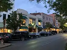
Hyde Park is a largely residential neighborhood, as such, its economy is focused towards small, privately-owned businesses. Hyde Park Square is considered the neighborhood's commercial district and hosts several family-owned shops and boutiques, restaurants, art galleries, banks, and real estate agencies.
Education
The Cincinnati Public Schools district operates public schools, including Withrow High School, Clark Montessori, Kilgour Elementary and The Hyde Park School.[16] Private schools in the neighborhood include the Summit Country Day School, the Springer School and Center, the Cardinal Pacelli School and St. Mary Grade School.
Hyde Park is also served by a branch of the Public Library of Cincinnati and Hamilton County.[17]
Schools
- Hyde Park School, elementary school
- Kilgour School, elementary school
- Withrow High School, high school
- Clark Montessori, high school
- Summit Country Day school, Catholic school
- Cardinal Pacelli School, Catholic school, part of the National Blue Ribbon School Program.[18]
- St. Mary Grade School, Catholic school, part of the National Blue Ribbon School Program.[18]
- Springer School and Center
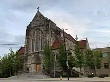
.jpg.webp) Hyde Park School
Hyde Park School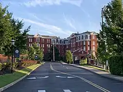 Summit Country Day School
Neighborhoods bordering Hyde Park
Also bordering Hyde Park is the city of Norwood.
Notable people
- Levi Addison Ault, Cincinnati Parks Commissioner
- Jim Borgman, Pulitzer Prize winning cartoonist
- Dana Fabe, Chief Justice, Alaska Supreme Court
- Jim Tarbell, entrepreneur, Former Cincinnati vice-mayor
References
- "Hyde Park - Statistical Neighborhood Approximation". Department of Planning and Buildings, City of Cincinnati. 2012-04-01. Retrieved 2019-04-10.
- "Statistical neighborhood approximation". City of Cincinnati. p. 2. Retrieved 27 January 2018.
- Rogers, Gregory Parker (Sep 27, 2010). Cincinnati's Hyde Park: A Queen City Gem. The History Press. ISBN 9781614231660. Retrieved 2013-05-08.
- Slifka, Brian Wingfield and Janeace. "Slide Show: America's Best Neighborhoods 2010". Forbes. Retrieved August 30, 2019.
- Cincinnati: A Guide to the Queen City and Its Neighbors. US History Publishers. 1979. pp. 305–307. ISBN 9781603540513.
- Delguzzi, Kristen (June 9, 1997). "A place synonymous with class: Neighbors appropriate its name because it has what people want". Cincinnati Enquirer. Archived from the original on May 14, 2008. Retrieved 2009-01-11.
- "Hyde Park: History". cincy.com. Retrieved August 28, 2019.
- Clarke, S. J. (1912). Cincinnati, the Queen City, 1788–1912, Volume 2. The S. J. Clarke Publishing Company. p. 528. Retrieved 2013-05-20.
- Charles Theodore Greve (1904). Centennial History of Cincinnati and Representative Citizens, Volume 1. Biographical Publishing Company. p. 960. Retrieved 2013-05-22.
- "Hyde Park Plan" (PDF). City of Cincinnati. August 25, 1982. Retrieved August 29, 2019.
- "NowData—NOAA Online Weather Data". National Oceanic and Atmospheric Administration. Retrieved 2019-10-02.
- "Station Name: KY CINCINNATI NORTHERN KY AP". National Oceanic and Atmospheric Administration. Retrieved 2014-03-30.
- "Records for Cincinnati". National Weather Service. Retrieved 2012-04-13.
- "WMO Climate Normals for CINCINNATI/GREATER CINCINNATI,KY 1961–1990". National Oceanic and Atmospheric Administration. Retrieved 2020-07-25.
- "Cincinnati, Ohio, USA - Monthly weather forecast and Climate data". Weather Atlas. Retrieved 4 July 2019.
- "About Hyde Park School". Cincinnati Public Schools. Retrieved August 22, 2019.
- "Hyde Park Branch". Public Library of Cincinnati and Hamilton County. Retrieved 12 June 2014.
- National Blue Ribbon Schools Program. "Schools Recognized" (PDF). U.S. Department of Education. Retrieved August 29, 2019.
Notes
- Mean monthly maxima and minima (i.e. the expected highest and lowest temperature readings at any point during the year or given month) calculated based on data at said location from 1981 to 2010.
- Official records for Cincinnati kept at downtown from January 1871 to March 1915, at the Cincinnati Abbe Observatory just north of downtown from April 1915 to March 1947, and at KCVG near Hebron, Kentucky since April 1947. For more information, see Threadex and History of Weather Observations Cincinnati, Ohio 1789–1947.
Further reading
- Cincinnati's Hyde Park (OH): A Brief History of a Queen City Gem (ISBN 1596299002), published by The History Press (September 24, 2010)
External links

| Authority control |
|
|---|