U.S. Route 10 Alternate (Washington–Montana)
U.S. Route 10 Alternate (US 10A) was an alternate route of US 10 that existed between 1941 and 1967. From 1941 to 1947, it ran between Seattle, Washington, and Missoula, Montana. It has since been replaced by Idaho State Highway 200, Montana State Highway 200, and US 2. By 1947,[2] it had been rerouted to run concurrently with US 95 as the majority of its former route from Sandpoint to Seattle had been replaced by US 2. This change led the highway to begin in Coeur d'Alene, Idaho, rather than in Seattle. It would remain in this configuration until its decommissioning in 1967, as I-90 gradually replaced US 10.[3]
| |
|---|---|
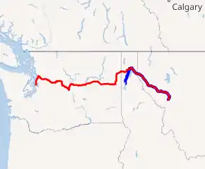
1941 alignment of US 10A highlighted in red 1947 alignment of US 10A in blue | |
| Route information | |
| Auxiliary route of US 10 | |
| Length | 567 mi[1][lower-alpha 1] (912 km) |
| Existed | 1941–1967 |
| Major intersections (in 1944) | |
| West end | |
| |
| East end | |
| Location | |
| States | Washington, Idaho, and Montana |
| Highway system | |
| |
.svg.png.webp)
Route description
Washington
US 10A spilt from US 10 in Seattle. The highway would then follow US 99 (modern Washington State Route 99) north to Everett. There it separated from US 99. It then traveled east across the Cascade Mountains via Stevens Pass to central Washington. In Spokane, the highway followed US 195 to Sandpoint, Idaho.
Idaho
.jpg.webp)
In Idaho, US 10A went through Bonner County and the town of Sandpoint. In Sandpoint, US 10A intersected US 95. At the intersection, US 195 terminated and US 10A would follow the shore of Lake Pend Oreille and go into Montana.
1947 reroute
After its reroute in 1947, US 10A started in Coeur d'Alene, Idaho concurrent with US 95. It would follow US 95 north to Sandpoint, Idaho. At the intersection with US 2, US 10A spilt from US 95 and went east towards Clark Fork, Idaho.
Montana
In Montana, the route would then follow through rural northwestern Montana and the towns of Plains and Thompson Falls. It then intersected US 93 in Ravalli, Montana. It then ran concurrently with US 93 south to Wye, Montana, where US 10A ended at Desmet Junction intersecting US 10 and US 93.
History
US 10A was formed in 1941, as a alternate route of US 10 going through northwestern Montana, northern Idaho, and central Washington. In Washington, it would follow the former route of US 10 before it was rerouted in 1939.[4] It served as an artery to isolated communities in those states, such as Clark Fork, Idaho, Plains, Montana, as well as several small towns in central Washington.
In 1946, representatives of the highway departments of Idaho and Washington proposed an extension of US 2 to Everett that was considered by the American Association of State Highway Officials's U.S. Route Numbering Committee in January 1946, however the committee vetoed the proposal. The proposal resurfaced during the committee's meeting on December 20, 1946, and US 2 was approved as a replacement for US 10A from Everett to Sandpoint and US 195 from Spokane to Newport. In 1947, following the extension of US 2, US 10A was rerouted to start in Coeur d'Alene along US 95.
US 10A was decommissioned in 1967, as its parent route, US 10, was being replaced by Interstate 90 (I-90). After its decommissioning, the states of Idaho and Montana had replaced the former US 10A route with state highways. Montana extended State Highway 20 to replace US 10A in 1967, while also renumbering the highway to 200. Idaho established State Highway 200 to replace US 10A a year later. Both highways were a part of a series of similarly numbered routes in Minnesota and North Dakota with the end goal being a unified federal designation.[5]
Major intersections
| State | County | Location | mi | km | Destinations | Notes |
|---|---|---|---|---|---|---|
| Washington | King | Seattle | Western end of US 99 concurrency; western terminus | |||
| Snohomish | Everett | Eastern end of US 99 concurrency | ||||
| Chelan | Peshastin | Western end of US 97 and PSH 2 concurrency | ||||
| Wenatchee | Eastern end of US 97 concurrency | |||||
| Spokane | Spokane | Western end of US 195 concurrency; eastern end of PSH 2 concurrency | ||||
| Pend Oreille | Newport | PSH 6 became State Route 20 in 1964[6] | ||||
| Idaho | Bonner | Sandpoint | Eastern end of US 195 concurrency; eastern terminus of US 195 | |||
| Montana | Sanders | Plains | ||||
| Lake | Ravalli | Western end of US 93 concurrency | ||||
| Missoula | Wye | Eastern terminus; Eastern end of US 93 concurrency | ||||
1.000 mi = 1.609 km; 1.000 km = 0.621 mi
| ||||||
1947 rerouting
| State | County | Location | mi | km | Destinations | Notes |
|---|---|---|---|---|---|---|
| Idaho | Kootenai | Coeur d’Alene | Southern end of US 95 concurrency; western terminus | |||
| Bonner | Sandpoint | Northern end of US 95 concurrency | ||||
| Montana | Sanders | Plains | ||||
| Lake | Ravalli | Western end of US 93 concurrency | ||||
| Missoula | Wye | Eastern terminus; eastern end of US 93 concurrency | ||||
1.000 mi = 1.609 km; 1.000 km = 0.621 mi
| ||||||
See also
 U.S. roads portal
Notes
- The length after the 1947 reroute was 223 miles (359 km).
References
- State Farm Insurance Companies Travel Bureau (1944). "State Farm Road Map: United States" (Map). State Farm Road Atlas United States Canada Mexico. 1:8,680,000. Chicago: Rand McNally. pp. 16–17. Retrieved September 6, 2020 – via David Rumsey Map Collection.
- Weingroff, Richard (June 27, 2017). "U.S. 2: Houlton, Maine, to Everett, Washington". Highway History. Federal Highway Administration. Retrieved September 6, 2020.
- Idaho Department of Highways; Rand McNally & Co. (1967). Official Highway Map of Idaho (Map). c. 1:1,425,600. Boise: Idaho Department of Highways. Retrieved September 6, 2020 – via Flickr.
- Highways of the State of Washington (DJVU) (Map). Department of Highways. 1939. Retrieved November 2, 2020.
- "New Map Changes Route 20". The Havre Daily News. October 18, 1967. p. 4. Retrieved November 9, 2020 – via Newspapers.com.
The ultimate goal of the highway association, Belding said, is federal designation.

- Prahl, C. G. (December 1, 1965). "Identification of State Highways" (PDF). Washington State Highway Commission. Retrieved October 23, 2020.
- Montana State Highway Commission; Rand McNally and Co. (1959). Map of the Montana State Highway System (PDF) (Map). Helena: Montana State Highway Commission. Retrieved October 30, 2020.
