Idaho State Highway 41
State Highway 41, abbreviated SH-41, is a state highway mostly in the U.S. state of Idaho. It runs from Interstate 90 in Post Falls to U.S. Route 2 on the Washington state line. The northernmost 0.41 miles (0.66 km) of SH-41 run along State Street along the state line, with the southbound lane in the town of Newport, Washington, and the northbound lane in Oldtown, Idaho. The part of the highway in Washington is designated State Route 41 (SR 41).
| |||||||
|---|---|---|---|---|---|---|---|
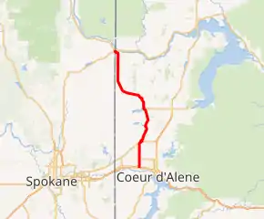
SH- 41 highlighted in red | |||||||
| Route information | |||||||
| Maintained by IDT and WSDOT | |||||||
| Length | 39.058 mi[1] (62.858 km) | ||||||
| Existed | 1931–present | ||||||
| Major junctions | |||||||
| South end | |||||||
| North end | |||||||
| Location | |||||||
| Counties | ID: Kootenai, Bonner WA: Pend Orielle | ||||||
| Highway system | |||||||
| |||||||

Route description
The southern terminus of State Highway 41 is located at the intersection of Ross Point Road and Seltice Way, just south of I-90 exit 7 in the city of Post Falls, Idaho.[3] The highway then proceeds north on the Ross Point – Rathdrum Highway, with a short concurrency with State Highway 53 in the city of Rathdrum.[4] It passes by Spirit Lake, intersecting State Highway 54, before turning northwest towards the Newport/Oldtown area.[5]
Shortly after crossing the Oldtown city limits, SH-41 intersects State Avenue, which straddles the state (and city) line between Oldtown, Idaho, and Newport, Washington. North of this intersection, the northbound lanes lie in Oldtown, while the southbound lanes lie in Newport. Approximately 7 blocks north of the intersection with State Avenue, SH-41 ends at U.S. Route 2.[1][6]
History
The Spirit Lake Highway was added to the Idaho state highway system on May 4, 1931, and designated as State Highway 41.[7]
State Street straddles the Washington–Idaho state line, with the southbound lane in Newport and the northbound lane in Oldtown, Idaho. Between Walnut and Fourth, the Idaho side of the street is part of State Highway 41, which runs from US-2 at the state line south to Interstate 90 at Post Falls. Until 1997, the Washington side of the street was part of US 2, which created confusion as each side of the street was part of a completely different highway. In 1997 the Washington side of State Street was designated SR 41 to match the Idaho numbering.
Major intersections
| State | County | Location | mi[1] | km | Destinations | Notes |
|---|---|---|---|---|---|---|
| Idaho | Kootenai | Post Falls | 0.000 | 0.000 | Seltice Way / Ross Point Road | |
| 0.030 | 0.048 | I-90 exit 7. | ||||
| | 0.170– 0.178 | 0.274– 0.286 | I-90 exit 7. | |||
| Rathdrum | 7.720 | 12.424 | South end of SH-53 overlap | |||
| 7.900 | 12.714 | North end of SH-53 overlap | ||||
| Spirit Lake | 18.134 | 29.184 | ||||
| Idaho–Washington | Bonner–Pend Oreille | Oldtown–Newport | 38.608 | 62.134 | State Avenue | |
| 39.058 | 62.858 | |||||
1.000 mi = 1.609 km; 1.000 km = 0.621 mi
| ||||||
References
- Idaho Transportation Department (January 29, 2008). "Milepost Log". Archived from the original on December 13, 2012. Retrieved April 10, 2008.
- Washington State Department of Transportation (2006). "State Highway Log" (PDF). Archived from the original (PDF) on April 10, 2008. Retrieved April 10, 2008.
- The Thomas Guide Pacific Northwest Road Atlas (Map) (7th ed.). Rand McNally. 2006. p. 354. § D7. ISBN 0-528-85869-6.
- The Thomas Guide Pacific Northwest Road Atlas (Map) (7th ed.). Rand McNally. 2006. p. 115. § A1. ISBN 0-528-85869-6.
- The Thomas Guide Pacific Northwest Road Atlas (Map) (7th ed.). Rand McNally. 2006. p. 106. § C3. ISBN 0-528-85869-6.
- Google (October 18, 2015). "Oldtown, ID" (Map). Google Maps. Google. Retrieved October 18, 2015.
- Downing, T.A. (April 15, 1937). "Designated Federal and State Highways Minute Book 09". Idaho Bureau of Highways. p. 32. Retrieved October 3, 2018 – via Idaho State Archives.
External links
| Wikimedia Commons has media related to Idaho State Highway 41. |
