San Fernando, La Union
San Fernando, officially the City of San Fernando (Ilocano: Siudad ti San Fernando, Pangasinan: Siyudad na San Fernando, Tagalog: Lungsod ng San Fernando), is a 3rd class component city in the province of La Union, Philippines. According to the 2015 census, it has a population of 121,812 people. [3]
San Fernando | |
|---|---|
| City of San Fernando | |
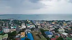 San Fernando Skyline | |
 Seal | |
| Nickname(s): The Prime Capital of Ilocandia Botanical Garden City | |
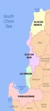
 Map of La Union with San Fernando highlighted | |
OpenStreetMap 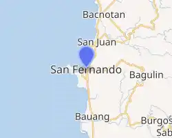
| |
.svg.png.webp) San Fernando Location within the Philippines | |
| Coordinates: 16°37′N 120°19′E | |
| Country | Philippines |
| Region | Ilocos Region (Region I) |
| Province | La Union |
| District | 1st District |
| Founded | 1850 |
| Cityhood | March 20, 1998 |
| Barangays | 59 (see Barangays) |
| Government | |
| • Type | Sangguniang Panlungsod |
| • Mayor | Hermenegildo A. Gualberto |
| • Vice Mayor | Alfredo Pablo R. Ortega |
| • Representative | Pablo C. Ortega |
| • Electorate | 72,655 voters (2019) |
| Area | |
| • Total | 102.72 km2 (39.66 sq mi) |
| Elevation | 101 m (331 ft) |
| Population | |
| • Total | 121,812 |
| • Density | 1,200/km2 (3,100/sq mi) |
| • Households | 27,912 |
| Economy | |
| • Income class | 3rd city income class |
| • Poverty incidence | 3.82% (2015)[4] |
| • Revenue | |
| • Assets | |
| • Expenditure | |
| Time zone | UTC+8 (PST) |
| ZIP code | 2500 |
| PSGC | |
| IDD : area code | +63 (0)72 |
| Climate type | tropical monsoon climate |
| Native languages | Ilocano Tagalog |
| Website | www |
San Fernando is the financial, industrial, and political center of the province, as well as the regional center of the Ilocos Region (Region I) in the Philippines.
Geography
The city is bounded by San Juan to the north, Bauang to the south, Bagulin and Naguilian to the east, and the South China Sea to the west. It has a land area of 10,272 hectares (25,380 acres). [2]
San Fernando is 269 kilometres (167 mi) from Metro Manila.
Barangays
San Fernando is divided into 59 barangays. [2]
- Abut
- Apaleng
- Bacsil
- Bangbangolan
- Bangcusay
- Barangay I (Poblacion)
- Barangay II (Poblacion)
- Barangay III (Poblacion)
- Barangay IV (Poblacion)
- Baraoas
- Bato
- Biday
- Birunget
- Bungro
- Cabaroan (Negro)
- Cabarsican
- Cadaclan
- Calabugao
- Camansi
- Canaoay
- Carlatan
- Catbangen
- Dallangayan Este
- Dallangayan Oeste
- Dalumpinas Este
- Dalumpinas Oeste
- Ilocanos Norte
- Ilocanos Sur
- Langcuas
- Lingsat
- Madayegdeg
- Mameltac
- Masicong
- Nagyubuyuban
- Namtutan
- Narra Este
- Narra Oeste
- Pacpaco
- Pagdalagan
- Pagdaraoan
- Pagudpud
- Pao Norte
- Pao Sur
- Parian
- Pias
- Poro
- Puspus
- Sacyud
- Sagayad
- San Agustin
- San Francisco
- San Vicente
- Santiago Norte
- Santiago Sur
- Saoay
- Sevilla
- Siboan-Otong
- Tanqui
- Tanquigan
Climate
| Climate data for San Fernando City, La Union | |||||||||||||
|---|---|---|---|---|---|---|---|---|---|---|---|---|---|
| Month | Jan | Feb | Mar | Apr | May | Jun | Jul | Aug | Sep | Oct | Nov | Dec | Year |
| Average high °C (°F) | 31 (88) |
31 (88) |
33 (91) |
33 (91) |
32 (90) |
31 (88) |
30 (86) |
30 (86) |
30 (86) |
31 (88) |
31 (88) |
31 (88) |
31 (88) |
| Average low °C (°F) | 21 (70) |
22 (72) |
23 (73) |
25 (77) |
26 (79) |
26 (79) |
26 (79) |
26 (79) |
25 (77) |
24 (75) |
23 (73) |
22 (72) |
24 (75) |
| Average precipitation mm (inches) | 42 (1.7) |
48 (1.9) |
74 (2.9) |
110 (4.3) |
269 (10.6) |
275 (10.8) |
362 (14.3) |
325 (12.8) |
330 (13.0) |
306 (12.0) |
126 (5.0) |
61 (2.4) |
2,328 (91.7) |
| Average rainy days | 11.2 | 12.0 | 17.1 | 21.2 | 27.1 | 26.8 | 28.1 | 27.0 | 26.0 | 24.5 | 17.7 | 12.4 | 251.1 |
| Source: Meteoblue (modeled/calculated data, not measured locally)[5] | |||||||||||||
History
Colonial history
San Fernando was founded in 1786 and was named after Saint Ferdinand III of Castile. The city's original settlements, San Vicente de Balanac and San Guillermo de Dalangdang, were attacked by pirates and headhunters.
In 1759, Augustinian friar José Torres fused these two settlements to Pindangan (local word for a place to dry fish), where a church dedicated to San Guillermo the Hermit was located; this church is now the Cathedral of St. William the Hermit. The massive 1860s earthquake destroyed the church which was later rebuilt.
After the formation of the province La Union, San Fernando became its cabecera or provincial capital in 1850.
From 1896 until 1898, during the Philippine Revolution, the Spanish garrison of San Fernando was attacked by Filipino revolutionaries under Manuel Tinio y Bundoc and Mauro Ortiz. Spanish administration ceased; a short while later, the United States acquired control over the country by the Treaty of Paris following the events of the Spanish–American War.
World War II
In the Second World War, the last battle of San Fernando was fought during the Japanese occupation at Barangay Bacsil. The Bacsil Ridge Monument was built on the site in the city, the north-eastern portion of the town plaza. The victory enabled the establishment of the United States Army Base, Base M at Poro Point (a buildup area for the Japan invasion).[6] The town was liberated in 1945.[7]
Martial law era
Although Ilocanos are perceived to have been largely silent about the authoritarian practices ,[8][9] there were still San Fernando residents willing to express their objections to the Marcos administration.[10] This included San-Fernando-raised student activists Romulo and Armando Palabay, UP Students and La Union National High School alumni who were imprisoned for their protest activities in San Fernando, tortured at Camp Olivas in Pampanga, and later separately killed before the end of Martial Law.[11] The respective martyrdoms of Romulo (age 22) and Armando (age 21) were later honored when their names were etched on the Wall of Remembrance at the Philippines’ Bantayog ng mga Bayani, which honors the heroes and martyrs who fought the authoritarian regime.[10]
Cityhood
San Fernando became a city by virtue of Republic Act No. 8509 signed into law on February 13, 1998 and ratified on March 20, 1998 by a plebiscite.[12]
Demographics
|
| ||||||||||||||||||||||||||||||||||||||||||||||||
| Source: Philippine Statistics Authority [3] [13] [14][15] | |||||||||||||||||||||||||||||||||||||||||||||||||
In the 2015 census, the population of San Fernando, La Union, was 121,812 people, [3] with a density of 1,200 inhabitants per square kilometre or 3,100 inhabitants per square mile.
Economy
San Fernando is mainly agricultural (rice, legumes, leafy vegetables, root crops, fruit trees, corn, and tobacco). But residents treat fishing in coastline and seashore areas as secondary means of livelihood. The natives also have inabel hand-woven cloth, baskets, shell crafts, including foods, such as kilawen and papaitan, basi, sukang iloko and paslubong such as guapples, longganiza, honey and native rice cakes, puto, suman, and bibingka.
Patopat is San Fernando's native delicacy, made from "agdapil" (sugarcane, a tall tropical Southeast Asian Grass (Saccharum officinarum).[16]
San Fernando has many class A hotels and resorts and night clubs.
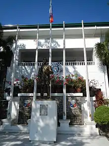
Local government
The mayor and other elected officers hold office at the city hall of San Fernando. The city council, the Sangguniang Panlungsod, is housed in the Don Mariano Marcos Building in beside of the city hall.
Elected officials
Elected officials (June 30, 2019 – 2022):[17]
- Mayor: Hermenegildo A. Gualberto
- Vice Mayor: Alfred Pablo R. Ortega
- Councilors:
- 1. NISCE, MARIA ROSARIO EUFROSINA PANIS
- 2. RAFON, ERNESTO VINLUAN
- 3. MIRANDA, JESSIE REFRE
- 4. VALERO, LUCIA ESPERANZA ORTEGA
- 5. ORROS, JOHN HERNANDEZ
- 6. ORTEGA, RAMON CAMPOS
- 7. ALMAZAN, ARNEL ALVIAR
- 8. JUCAR, ANTONIO GACAYAN
- 9. LAUDENCIA, RIZALDE FRIGILLANA
- 10. PACIO, JANWELL EISMA
- 11. ABAT, RODOLFO MONDINA
- 12. BALCITA, QUINTIN JR. LETE
List of chief executives
- 1895–1898 — Paulino Alviar
- 1899–1901 — Blas Tadiar
- 1901–1903 — Urbano Martínez
- 1904–1905 — Edilberto Aquino
- 1906–1907 — Francisco Z. Flores
- 1908–1909 — Angel Salanga
- 1910–1911 — José Hidalgo
- 1912–1914 — Anastacio Casuga
- 1915–1918 — Juan Salanga
- 1919–1921 — Ulpiano Flores
- 1922–1928 — Pedro R. Flores
- 1928 — Francisco Galvez
- 1928–1930 — Evaristo Galvez
- 1931–1933 — Gaspar Flores
- 1934–1936 — Lauro Casuga
- 1936–1939 — Paulino Flores
- 1942–1944 — Juan Salanga
- 1945–1946 — Modesto Aquino
- 1946–1955 — Lorenzo L. Dacanay
- 1956–1959 — Godofredo G. Rilloraza
- 1960–1971 — Lorenzo L. Dacanay
- 1972–1980 — Antonio Feraren
- 1980 — Joaquin T. Ortega
- 1980–1987 — Justo O. Orros Jr.
- 1987 — Rufo T. Colisao
- 1987–1988 — Angel Salanga
- 1988–1998 — Manuel C. Ortega
- 1998–2007 — Mary Jane C. Ortega
- 2007–2016 — Pablo C. Ortega
- 2016–2020 — Hermenegildo A. Gualberto
- 2020 — Alfredo Pablo R. Ortega
- 2020–Present — Hermenegildo A. Gualberto
Annual community events

The city has a yearly fiesta, celebrated from January 28 to February 15, where a trade fair is opened near the city hall.
Celebrations are also done around March, in celebration of Cityhood.
The following events happen annually: Annual City Fiesta, February 10; Bacsil Ridge Celebration, March 19; Pindangan Festival, March 20; Ma-tzu Festival, September 16.[18][19]
Tourism
- Poro Point
- Poro Point Special Economic and Freeport Zone (formerly American Military Base – Wallace Air Station)
- Thunderbird Resorts
- Boardwalk
- The La Union Botanical Garden (8 kilometers from the city) – is a 10 hectare garden (Barangay Cadaclan), the home of various species of rare plants and a sanctuary of wild animals.
- Battle of Bacsil Ridge Marker
- Pindangan Ruins (Barangay Parian)
- Hobbitat Forest Park
- Poro Point Baywalk (Barangay Poro)
- Seven Hills
- Capitol Hill (Barangay II) home of the Provincial Capitol
- Pagoda Hill also known as Filipino-Chinese Friendship Park or Chinese Pagoda (Barangay II)
- Heroes’ Hill & Freedom Park Stairway (153 steps) located at the eastern portion of Capitol Hill
- Bethany Hill (Barangay II)
- Mirador Hill (Barangay II)
- Mariner's Hill (Barangay Catbangen)
- Miracle Hill (Barangay Pagdaraoan)
- Christ the Redeemer (25-foot statue, Reservoir Hill, Barangay I)
- Poro Point Lighthouse
- Moro Watch Tower (Barangay Carlatan)
- La Union Science Centrum & Museum (LUSCM has 5 Galleries: Kadaklan Burial Site and Environmental Gallery, Museum, Dark Room, Main Science Gallery and Portable Planetarium (Barangay Cadaclan)
- Ma-Cho Temple
- Tomb of Unknown Soldier (Barangay Madayegdeg)
- Cathedral of St. William the Hermit (Barangay II, Poblacion)
- Kasay Marine Sanctuary: 30 hectares MPA, featuring the 50 years old Giant clam or Tridacna gigas (Barangay Canaoay)
- Children's Park (Barangay II, City Plaza)
- 10.6 hectares Engineered Sanitary Landfill (Barangay Mameltac)[20]
- La Union Trade Center (beside the City Hall)
Notable people
- Armando Palabay - Human rights activist and martyr honored at the
- Roger Casugay – surfer
- Lucrecia Kasilag — Composer, Dean of the Philippine Women’s University College of Music and Fine Arts (1953-1977), President of the Cultural Center of the Philippines (1976-1986) Awardee of the Order of National Artists of the Philippines
Sister cities
 Ansan, South Korea
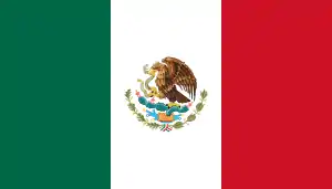 Coatzacoalcos, Mexico
 Naga, Camarines Sur
- Valenzuela City
References
- City of San Fernando | (DILG)
- "Province: La Union". PSGC Interactive. Quezon City, Philippines: Philippine Statistics Authority. Retrieved 12 November 2016.
- Census of Population (2015). "Region I (Ilocos Region)". Total Population by Province, City, Municipality and Barangay. PSA. Retrieved 20 June 2016.
- "PSA releases the 2015 Municipal and City Level Poverty Estimates". Quezon City, Philippines. Retrieved 1 January 2020.
- "San Fernando: Average Temperatures and Rainfall". Meteoblue. Retrieved 26 April 2020.
- "Battle of San Fernando Marker in San Fernando (La Union)". localphilippines.com. Archived from the original on 2 June 2014. Retrieved 4 October 2016.
- "History". Official Website of San Fernando, La Union. Archived from the original on 27 January 2015. Retrieved 4 October 2016.
- "From 1987: 'A Damaged Culture' in the Philippines - The Atlantic". Archived from the original on 2016-10-28. Retrieved 2020-01-22.
- Manila Today. Mula Sigwa hanggang Commune hanggang EDSA: mga kabataangmartir at bayani ng UP.2016-01-27 https://manilatoday.net/fqs-martyrs/
- Burgonio, TJ Museum puts a face on little-known martial law martyrs Philippine Daily Inquirer 2008-09-21 https://barangayrp.wordpress.com/2008/09/21/museum-puts-a-face-on-little-known-martial-law-martyrs/
- "PALABAY, Armando D. – Bantayog ng mga Bayani". bantayog.org. Retrieved 2020-01-22.
- "Republic Act No. 8509 – An Act Converting the Municipality of San Fernando, La Union, Into a Component City To Be Known As the City of San Fernando". Chan Robles Virtual Law Library. 13 February 1998. Retrieved 4 October 2016.
- Census of Population and Housing (2010). "Region I (Ilocos Region)". Total Population by Province, City, Municipality and Barangay. NSO. Retrieved 29 June 2016.
- Censuses of Population (1903–2007). "Region I (Ilocos Region)". Table 1. Population Enumerated in Various Censuses by Province/Highly Urbanized City: 1903 to 2007. NSO.
- "Province of La Union". Municipality Population Data. Local Water Utilities Administration Research Division. Retrieved 17 December 2016.
- Madrid, Myla B. (6 July 2010). ""Patopat", A Native Delicacy". Official Website of San Fernando, La Union. Archived from the original on 11 August 2010. Retrieved 4 October 2016.
- https://comelec.gov.ph/index.html?r=2019NLE/ElectionResults_. Missing or empty
|title=(help) - Flores, Anne Hazel F. (July 6, 2010). "City celebrates feast of St. William the Hermit". Official Website of San Fernando, La Union. Archived from the original on 2011-01-28. Retrieved 2012-12-11.
- Madrid, Myla B. (July 6, 2010). "Pindangan Festival 2010". Official Website of San Fernando, La Union. Archived from the original on 2010-10-19. Retrieved 2012-12-11.
- "Tourist Attractions". Official Website of San Fernando, La Union. Archived from the original on 2012-05-01. Retrieved 2012-12-11.
External links
| Wikivoyage has a travel guide for San Fernando, La Union. |
| Wikimedia Commons has media related to San Fernando City, La Union. |
| Wikisource has the text of a 1905 New International Encyclopedia article about "San Fernando, La Union". |
- San Fernando Profile at PhilAtlas.com
- Official website
- R.A. 8508 – "Charter of the City of San Fernando."
- Philippine Standard Geographic Code
- Philippine Census Information
- Local Governance Performance Management System
Places adjacent to San Fernando, La Union | ||||||||||
|---|---|---|---|---|---|---|---|---|---|---|
| ||||||||||
San Fernando (capital) | |
| Municipalities | |
| Component city | |
| Barangays | |
| Authority control |
|
|---|