Independence Airport
Independence Airport (FAA LID: 2O7) is a public airport located one mile (1.6 km) north of Independence, serving Inyo County, California, United States. It has two runways and is mostly used for general aviation.
Independence Airport Independence Air Force Auxiliary Field | |||||||||||||||
|---|---|---|---|---|---|---|---|---|---|---|---|---|---|---|---|
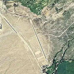 2006 USGS airphoto | |||||||||||||||
| Summary | |||||||||||||||
| Airport type | Public | ||||||||||||||
| Location | Independence, California | ||||||||||||||
| Elevation AMSL | 3,900 ft / 1,189 m | ||||||||||||||
| Coordinates | 36°48′49.756″N 118°12′18.34″W | ||||||||||||||
| Map | |||||||||||||||
 2O7 Location of Independence Airport | |||||||||||||||
| Runways | |||||||||||||||
| |||||||||||||||
Facilities
Independence Airport has two runways:
- Runway 14/32: 3,722 x 60 ft (1,134 x 18 m), surface: asphalt
- Runway 05/23: 1,610 x 30 ft (491 x 9 m), surface: dirt
History
During World War II, the airport was used by the United States Army Air Forces as an auxiliary training airfield for the flying school at Lone Pine Airport, California.
References
![]() This article incorporates public domain material from the Air Force Historical Research Agency website http://www.afhra.af.mil/.
This article incorporates public domain material from the Air Force Historical Research Agency website http://www.afhra.af.mil/.
- Airport Master Record (FAA Form 5010), also available as a printable form (PDF)
External links
- Resources for this airport:
- FAA airport information for 2O7
- AirNav airport information for 2O7
- FlightAware airport information and live flight tracker
- SkyVector aeronautical chart for 2O7
This article is issued from Wikipedia. The text is licensed under Creative Commons - Attribution - Sharealike. Additional terms may apply for the media files.
