Inka P'iqi
Inka P'iqi (Aymara p'iqi, p'iq'iña, phiq'i, phiq'iña head, Inka Inca,[2][3] "Inca head", also spelled Inca Pekhe) is a 4,110-metre-high (13,480 ft) mountain in the Bolivian Andes. It is located in the Cochabamba Department, on the border of the Arani Province, Vacas Municipality, and the Mizque Province, Alalay Municipality. Inka P'iqi lies southwest of Jatun Llallawa and south of Juch'uy Llallawa.[1][4]
| Inka P'iqi | |
|---|---|
 Inka P'iqi Location within Bolivia | |
| Highest point | |
| Elevation | 4,110 m (13,480 ft) [1] |
| Coordinates | 17°41′39″S 65°34′53″W |
| Geography | |
| Location | Bolivia, Cochabamba Department |
| Parent range | Andes |
References
- Bolivia 1:100,000 Punata 3735
- Radio San Gabriel, "Instituto Radiofonico de Promoción Aymara" (IRPA) 1993, Republicado por Instituto de las Lenguas y Literaturas Andinas-Amazónicas (ILLLA-A) 2011, Transcripción del Vocabulario de la Lengua Aymara, P. Ludovico Bertonio 1612 (Spanish-Aymara-Aymara-Spanish dictionary) see: cabeza; phiq'i; phiq'iña; p'iq'iña
- "Diccionario Bilingüe, Castellano - Aymara, 2002". Félix Layme Pairumani. Archived from the original on September 2, 2013. Retrieved April 6, 2016. (see: Cabeza)
- "Vacas". INE, Bolivia. Archived from the original on March 4, 2016. Retrieved April 6, 2016.
Capital: Cochabamba | ||
| Provinces | 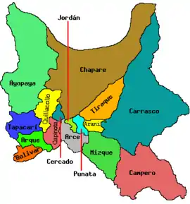 | |
| Municipalities (and seats) |
| |
This article is issued from Wikipedia. The text is licensed under Creative Commons - Attribution - Sharealike. Additional terms may apply for the media files.