Villa Tunari
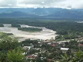
Villa Tunari or Tunari is a location in the department of Cochabamba, Bolivia. It is the seat of the Villa Tunari Municipality, the third municipal section of the Chapare Province. According to the census 2012 the population was 3,213 in the town which is an increment from 2,510 registered during the 2001 census.[1]
Villa Tunari | |
|---|---|
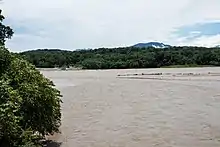
 Villa Tunari with Espíritu Santo River (upper right) and San Mateo River | |
 Villa Tunari Location within Bolivia | |
| Coordinates: 16°58′S 65°25′W | |
| Country | |
| State | Cochabamba Department |
| Province | Chapare Province |
| Municipality | Villa Tunari Municipality |
| Canton | Villa Tunari Canton |
| Population (2012) | |
| • Total | 3,213 |
| Time zone | UTC-4 (UTC) |
Villa Tunari has several parks located nearby including Parque Machía and Carrasco National Park. Parque Machía is home to one of three wildlife centers maintained by Comunidad Inti Wara Yassi and supported by international volunteers. Villa Tunari is famous among tourists due to the tropical weather and due to nearby national parks. Recently the town gained important infrastructure due to the tourist industry and because a new paper industry seated near to the town.
Population
The population increased moderately from 2001 census because little rural communities were settled near to the town. Most of people are quechua descent and the main spoken languages are Spanish and Quechua.
| year | Population | Reference |
|---|---|---|
| 1992 | 1 597 | census[2] |
| 2001 | 2 510 | census[3] |
| 2012 | 3 210 | census[4] |
Climate
Under the Köppen climate classification, Villa Tunari has a tropical rainforest climate with a lengthy rainy season, a shorter dry season and ample precipitation throughout the year.
| Climate data for Villa Tunari | |||||||||||||
|---|---|---|---|---|---|---|---|---|---|---|---|---|---|
| Month | Jan | Feb | Mar | Apr | May | Jun | Jul | Aug | Sep | Oct | Nov | Dec | Year |
| Record high °C (°F) | 37 (99) |
37 (99) |
37 (99) |
40 (104) |
42 (108) |
39 (102) |
38 (100) |
40 (104) |
37 (99) |
40 (104) |
38 (100) |
37 (99) |
42 (108) |
| Average high °C (°F) | 30.9 (87.6) |
30.8 (87.4) |
31.1 (88.0) |
30.6 (87.1) |
29.1 (84.4) |
28.4 (83.1) |
29.0 (84.2) |
30.8 (87.4) |
30.6 (87.1) |
32.6 (90.7) |
31.9 (89.4) |
31.4 (88.5) |
31.4 (88.5) |
| Daily mean °C (°F) | 26.9 (80.4) |
27.0 (80.6) |
27.1 (80.8) |
26.1 (79.0) |
24.5 (76.1) |
22.8 (73.0) |
22.6 (72.7) |
24.0 (75.2) |
24.7 (76.5) |
26.7 (80.1) |
26.9 (80.4) |
27.0 (80.6) |
25.5 (77.9) |
| Average low °C (°F) | 22.9 (73.2) |
23.2 (73.8) |
23.1 (73.6) |
21.6 (70.9) |
19.9 (67.8) |
17.1 (62.8) |
16.2 (61.2) |
17.2 (63.0) |
18.9 (66.0) |
20.9 (69.6) |
22.0 (71.6) |
22.6 (72.7) |
20.5 (68.9) |
| Record low °C (°F) | 15 (59) |
16 (61) |
13 (55) |
12 (54) |
8 (46) |
7 (45) |
3 (37) |
7 (45) |
10 (50) |
12 (54) |
12 (54) |
13 (55) |
3 (37) |
| Average precipitation mm (inches) | 606.0 (23.86) |
523.0 (20.59) |
501.3 (19.74) |
303.2 (11.94) |
214.1 (8.43) |
160.4 (6.31) |
114.8 (4.52) |
114.2 (4.50) |
151.5 (5.96) |
279.1 (10.99) |
336.7 (13.26) |
501.6 (19.75) |
3,805.9 (149.84) |
| Source 1: Sistema de Clasificación Bioclimática Mundial[5] | |||||||||||||
| Source 2: Weatherbase[6] | |||||||||||||
Sports
The Estadio Olímpico Bicentenario de Villa Tunari is located in Villa Tunari. The 25,000-capacity stadium is used for football matches. It opened on 8 September 2018.
See also
References
- World-Gazetteer Archived July 18, 2011, at the Wayback Machine
- INE – Instituto Nacional de Estadística Bolivia 1992 Archived 2014-01-28 at WebCite
- INE – Instituto Nacional de Estadística Bolivia 2001 Archived March 4, 2016, at the Wayback Machine
- INE – Instituto Nacional de Estadística Bolivia 2012 Archived March 4, 2016, at the Wayback Machine
- "Bolivia- Trinidad" (in Spanish). Centro de Investigaciones Fitosociológicas. Retrieved December 24, 2012.
- "Weatherbase: Historical Weather for Trinidad, Bolivia". Weatherbase. Retrieved December 24, 2012.
External links
| Wikimedia Commons has media related to Villa Tunari. |
Capital: Cochabamba | ||
| Provinces | 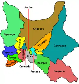 | |
| Municipalities (and seats) |
| |
.