Interstate 184
Interstate 184 (I-184) is a short Auxiliary Interstate Highway in Boise, Idaho. It is a spur route of I-84 that connects the freeway to Downtown Boise, terminating at U.S. Route 20 (US 20) and U.S. Route 26 (US 26). The Interstate is also known as the Boise Connector.[2]
| ||||
|---|---|---|---|---|
| Boise Connector | ||||
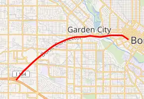
I-184 highlighted in red | ||||
| Route information | ||||
| Auxiliary route of I-84 | ||||
| Maintained by ITD | ||||
| Length | 3.62 mi[1] (5.83 km) | |||
| Existed | 1990–present | |||
| History | Completed in 1990 | |||
| Major junctions | ||||
| West end | ||||
| East end | ||||
| Location | ||||
| Counties | Ada | |||
| Highway system | ||||
| ||||

Route description
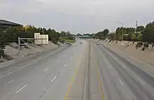
I-184 begins at the "Flying Wye" interchange with I-84 and US 30 in southwestern Boise.[3][4] The six-lane freeway travels northeast through suburban Boise, crossing over a spur railroad near an interchange with Franklin Street on the south side of the Boise Towne Square shopping mall. I-184 intersects Curtis Road near the Saint Alphonsus Regional Medical Center and turns due east along Fairview Avenue, which acts a frontage road. On the west side of the Boise River in Rotary Park, I-184 terminates after an interchange with US 20 and US 26, which serve northwestern Boise on Chinden Boulevard. US 20 and US 26 supersede I-184 and cross into Downtown Boise, where it splits into Front and Myrtle streets.[3][5]
Interstate 184 is the only three-digit Interstate route in Idaho and the state's shortest, at 3.62 miles (5.83 km).[3] The highway is maintained by the Idaho Transportation Department (ITD), which conducts an annual survey of traffic on certain highway segments that is expressed in terms of average annual daily traffic (AADT), a measure of traffic volume for any average day of the year. The sole traffic recording device on I-184 reported a daily average of 81,140 vehicles on the highway in 2017.[6]
History
The Boise Connector was planned in the early 1960s to connect the Boise freeway bypass to downtown Boise and its inner neighborhoods.[7] One version of the plan proposed a full loop bisecting downtown Boise to carry Interstate 80N (I-80N), but it was rejected in favor of a less costly spur route.[8] The westernmost section of the connector, including a sprawling wye interchange with I-80N, was opened to traffic on December 12, 1968, a year before the rest of the bypass.[3][9] Parts of the connector were signed as part of SH-55 until it was realigned in the 1980s.
| |
|---|---|
| Location | Boise |
| Existed | 1968–1979 |
| |
|---|---|
| Location | Boise |
The freeway was numbered Interstate 180N until October 13, 1979, when I-184 was adopted to match I-84, which was planned to succeeded I-80N.[10] It was the only signed suffixed auxiliary Interstate route in the nation.[3]
When Interstate 80N was redesignated Interstate 84, this highway was re-designated Business Loop I-84 through Boise. The current I-184 designation was signed when the construction upgrading the route to Interstate standards was completed in 1990. The new bridge across the Boise River was opened on August 7, 1992, replacing a pair of smaller bridges to the north.[11] The westernmost segment of I-184, including the Flying Wye interchange, was rebuilt from 1999 to 2004 to accommodate an additional set of lanes.[7] The project cost $86 million and was delayed several times due to a dispute with the Environmental Protection Agency.[12]
Exit list
The entire route is in Boise, Ada County.
| mi[1] | km | Exit | Destinations | Notes | ||
|---|---|---|---|---|---|---|
| 0.00 | 0.00 | Western terminus; I-84 exit 49 | ||||
| 0.67 | 1.08 | 0 | Westbound exit and eastbound entrance; serves Boise International Airport | |||
| 1.08 | 1.74 | 1A | Franklin Road | |||
| 1.33 | 2.14 | 1B | Cole Road | Westbound exit and eastbound entrance | ||
| 2.54 | 4.09 | 2 | Curtis Road | Westbound exit also signed as "Fairview Avenue" | ||
| 2.81– 3.09 | 4.52– 4.97 | 3 | Fairview Avenue | Westbound access is part of exit 2 | ||
| 3.62 | 5.83 | No access to US-20/US-26 west; continuation as freeway beyond eastern terminus | ||||
| 1.000 mi = 1.609 km; 1.000 km = 0.621 mi | ||||||
References
- "Milepoint Log: Interstate 184" (PDF). Idaho Transportation Department. January 25, 2016. Retrieved July 19, 2018.
- "SPEED LIMITS INCREASE ON IDAHO HIGHWAYS". Deseret News. Deseret Management Corporation. AP. May 14, 1996. Retrieved April 20, 2020.
- "Interstate 184 – Idaho". Idaho Transportation Department. May 2006. Archived from the original on September 1, 2010. Retrieved June 21, 2018.
- Wagner, Morgan (January 15, 2016). "Find yourself in a crash along the Flying Wye? Look for the color codes!". KBOI. Retrieved July 19, 2018.
- Google (April 20, 2020). "Flying Wye interchange" (Map). Google Maps. Google. Retrieved April 20, 2020.
- "County #226 - Emerald". Idaho Transportation Department. Retrieved July 19, 2018.
- Wyatt, Liz (February 7, 1999). "Rebuilding the Wye interchange". Idaho Statesman. p. 15A.
- "The Roads Not Taken: Boise and the Interstate Highway, 1960". Boise State University Library. Archived from the original on May 23, 2011. Retrieved July 22, 2018.
- Quintana, Craig (August 11, 1999). "Idaho delegates pressure EPA to call air clean". Idaho Statesman. p. 1A.
- Special Committee on U.S. Route Numbering (October 13, 1979). "Route Numbering Committee Agenda Showing Action Taken by the Executive Committee" (PDF) (Report). Washington, DC: American Association of State Highway and Transportation Officials. p. 1. Retrieved July 19, 2018 – via Wikimedia Commons.
- "Drivers ease on down Boise's new roadway". Idaho Statesman. August 8, 1992. p. 1A.
- Sewell, Cynthia (December 2, 2005). "State to unveil landscaping options for the Wye". Idaho Statesman. p. 1A.
External links
Auxiliary routes of highways designated as Interstate 84 | ||
|---|---|---|
| Oregon–Utah segment | ||
| Pennsylvania–Massachusetts segment | ||
1Former | ||