Interstate 225
Interstate 225 (I-225) is a connector spur route of Interstate 25 in Colorado. It is the only auxiliary route of Interstate 25, and one of two auxiliary Interstate highways in the state of Colorado. I-225 traverses Aurora and small portions of Denver and Greenwood Village. It runs north from Interstate 25 to Interstate 70. It intersects with Interstate 70 Business/U.S. Highway 40/U.S. Highway 287, known locally as Colfax Avenue. Construction on the freeway began in 1964 and continued progressively through many years until final completion in 1976.
| ||||
|---|---|---|---|---|
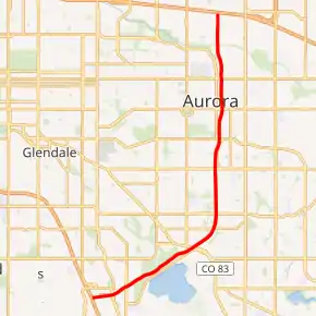
I-225 highlighted in red | ||||
| Route information | ||||
| Auxiliary route of I-25 | ||||
| Maintained by CDOT | ||||
| Length | 11.959 mi[1] (19.246 km) | |||
| Existed | 1976[2]–present | |||
| Major junctions | ||||
| South end | ||||
| North end | ||||
| Location | ||||
| Counties | Denver, Arapahoe, Adams | |||
| Highway system | ||||
|
Colorado State Highways
| ||||

Route description
The southern end of I-225 begins at an interchange with Interstate 25, as a typical four lane interstate with a 65 mph speed limit. The road heads northeastward through southern Denver,[3] and after exits with DTC Boulevard and Yosemite Street in Greenwood Village,[4] the road becomes six lanes with an auxiliary lane in each direction traversing the Denver/Greenwood Village city limits. With Cherry Creek State Park and Cherry Creek Reservoir on its east side, the highway interchanges with State Highway 83 at the northern boundary of the park. Following the exit at SH 83, the freeway enters Aurora,[5] where it turns northward, maintaining six through lanes and auxiliary lanes at each exit, and a 65 mph speed limit to its northern terminus at I-70,[6] and has upgraded exits at Iliff Avenue, Mississippi Avenue, Alameda Avenue, and 6th Avenue (also signed as State Highway 30).[7] After crossing Sand Creek, the freeway interchanges with Colfax Avenue (also signed as U.S. Highway 40, U.S. Highway 287 and Interstate 70 Business), and then with 17th Place (serving the Anschutz Medical Campus).[7] After the exit, I-225 enters Adams County, continuing through the city of Aurora. The route then crosses a railroad[8] and continues north, where it interchanges with Interstate 70.[1] The northbound ramp to westbound I-70 reenters Denver, and the eastbound I-70 to southbound I-225 ramp originates in Denver but enters Aurora as it passes under westbound I-70 to southbound I-225 ramp.[5]
History
Construction on I-225 began in May 1964 at Interstate 70. A section from Colfax Avenue to Sixth Avenue was opened in 1966. Five years later, a segment between Mississippi Avenue and Parker Road was opened, and construction began on another segment south of Parker Road, completed in May 1975. The rest of the route between Yosemite Street and Interstate 25 was completed in May 1976.[2] The portion from I-25 to SH 83 / Parker Road was rebuilt as part of the T-REX Project completed in 2006.[9] The highway was later widened between Parker Road and Mississippi Avenue to six lanes, as part of a project to widen the entire freeway to I-70; construction on this portion took place between May 2012 and November 2014.[10] Two infill interchanges have opened since the highway was completed – Alameda Avenue in 2002 and 17th Place in 2013.
Exit list
| County | Location | mi[1] | km | Exit | Destinations | Notes |
|---|---|---|---|---|---|---|
| City and County of Denver | 0.00 | 0.00 | 1A-B | I-25 exit 200; signed as left exit 1A (south) & 1B (north); tri-stack interchange. | ||
| Arapahoe | Greenwood Village | 0.673 | 1.083 | 2A | DTC Boulevard, Tamarac Street | Signed as exit 2 northbound |
| 1.333 | 2.145 | 2B | Yosemite Street | Southbound exit and northbound entrance | ||
| Aurora | 3.946 | 6.350 | 4 | |||
| 5.373 | 8.647 | 5 | Iliff Avenue | |||
| 6.886 | 11.082 | 7 | Mississippi Avenue | |||
| 7.921 | 12.748 | 8 | Alameda Avenue | Offset single-point urban interchange, opened in 2002.[11] | ||
| 8.953 | 14.408 | 9 | ||||
| Adams | 9.901 | 15.934 | 10A | Signed as exit 10 southbound | ||
| 10.151 | 16.336 | 10B | 17th Place | Southbound exit is via exit 10. Opened on February 15, 2013.[12] | ||
| Adams–Denver county line | Aurora–Denver line | 11.997 | 19.307 | 12A-B | I-70 exit 282; signed as left exit 12A (west) & 12B (east); tri-stack interchange. | |
| 1.000 mi = 1.609 km; 1.000 km = 0.621 mi | ||||||
See also
 Colorado portal
 U.S. Roads portal
References
- Staff. "Segment Descriptions for Highway 225". Colorado Department of Transportation. Archived from the original on July 14, 2011. Retrieved June 4, 2010.
- Staff. "Interstate 225". Colorado Department of Transportation. Archived from the original on July 16, 2011. Retrieved June 4, 2010.
- Denver (Map). Cartography by CDOT. Colorado Department of Transportation. Archived from the original on July 14, 2011. Retrieved June 14, 2010.
- Greenwood Village (Map). Cartography by CDOT. Colorado Department of Transportation. Archived from the original on July 14, 2011. Retrieved June 14, 2010.
- Microsoft; Nokia (June 14, 2010). "I-225" (Map). Bing Maps. Microsoft. Retrieved June 14, 2010.
- Staff. "I-225 Widening Project". Colorado Department of Transportation. Retrieved February 16, 2016.
- Staff. "Interchange Information of Highway 225". Colorado Department of Transportation. Archived from the original on July 14, 2011. Retrieved February 16, 2016.
- Aurora (Map). Cartography by CDOT. Colorado Department of Transportation. Archived from the original on July 14, 2011. Retrieved June 14, 2010.
- T-REX Factbook- Project Background Page 6, https://web.archive.org/web/20041111094231/http://trexproject.com/trex_content/about/trex_2003_factbook.pdf
- "I-225 Widening". Colorado Department of Transportation. Archived from the original on June 21, 2015. Retrieved June 21, 2015.
- https://www.aaroads.com/guides/i-225-co/#:~:text=2002%20%2D%20Alameda%20Avenue%20interchange%20opens,of%20T%2DREX%20project).
- "New Fitzsimons Interchange at I-225 and Colfax in Aurora to be unveiled Monday". Denver Post. Retrieved February 24, 2013.