Interstate 585
Interstate 585 (I-585) is a 3.5 miles (5.6 km)-long spur route of I-85 in the U.S. State of South Carolina. While the route ends at the northern city limits, it travels through the Spartanburg suburbs of Valley Falls and Southern Shops and passes by the campus of University of South Carolina Upstate. It follows a former street known as North Pine Street, which is still borne by frontage roads that line either side of the freeway. The southern terminus is at U.S. Route 221 (US 221). The entire route is concurrent with US 176, which continues north of I-85 as Asheville Highway, and south of US 221 as North Pine Street. Prior to 2006, the designation ended at I-85 Business, an old alignment of I-85, but the route was upgraded to extend it to its parent route at that time. Despite the signage, most of the route is not up to Interstate Highway standards.
| ||||
|---|---|---|---|---|
| North Pine Street | ||||
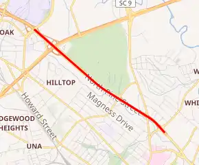
Part of I-585 highlighted in red. Since 2006, the route has extended an additional 1.25 miles to the north | ||||
| Route information | ||||
| Auxiliary route of I-85 | ||||
| Maintained by SCDOT | ||||
| Length | 3.50 mi[1][2] (5.63 km) | |||
| Existed | 1962–present | |||
| Major junctions | ||||
| South end | ||||
| North end | ||||
| Location | ||||
| Counties | Spartanburg | |||
| Highway system | ||||
| ||||
.svg.png.webp)
Route description
I-585 is co-signed the entire length with US 176 and it uses US 176's exit number system instead of its own. The route is also signed as North Pine Street its entire length. The southern terminus begins at exit 25, where the road continues as US 176; SC 9. I-585 remains concurrent with US 176 starting at exit 25 as it heads northwest. It then comes across a partial interchange with California Avenue at exit 24. Before exit 23, there are two at-grade auxiliary lanes, one on each side which connects Milliken Road on the north side and Graham Road on the south side to the highway. At exit 23, the highway comes across I-85 Business, forming a parclo interchange. Only the northbound lanes on I-85 Business don't have access to the westbound lanes on I-585. The highway then passes by USC-Upstate as it forms an interchange at an unnumbered exit at East Campus Boulevard, to provide access to the campus from the interstate. Then, the highway interchanges with Valley Falls Road at an unnumbered exit to also provide access to USC-Upstate from the west side. It then comes across an at-grade intersection with Upper Valley Falls Road before reaching its northern terminus at I-85 at a diamond interchange with two traffic signals for I-585.[3][4]
History
From the highway's initial designation until 1995, I-85 followed what is now designated I-85 Business. In that year, I-85 moved to the north, orphaning I-585 from a direct connection to its parent route, a situation that remained until upgrades to US 176 over the next decade provided a freeway connection between I-85 and I-85 Business. By 2006, the original route was extended an additional 1.25 miles (2.01 km) from its prior northern end to its current terminus at I-85. Today, the entire route is signed as I-585 from I-85 to US 221.[4]
Exit list
Exit numbers, where present, are based on US 176 mileage. The entire route is in Spartanburg County.
| Location | mi[5] | km | Exit | Destinations | Notes |
|---|---|---|---|---|---|
| Spartanburg | 0.000 | 0.000 | — | Continuation as US 176/SC 9 | |
| | 0.170– 0.420 | 0.274– 0.676 | 25 | Southern end of SC 9 concurrency; official northern terminus of I-585; western terminus of US 176 Conn.; northern terminus of Whitney Road and North Church Street; signed exit 25B (US 221) and 25A (SC 9 northbound) for I-585 northbound; no northbound entrance from exit 25A | |
| | 0.900 | 1.448 | 24 | California Avenue | Northbound exit and southbound entrance |
| Southern Shops–Valley Falls line | 2.067– 2.076 | 3.327– 3.341 | 23 | Signed as exits 23A (south) and 23B (north) | |
| – | East Campus Boulevard – USC Upstate | ||||
| – | Valley Falls Road | ||||
| – | Upper Valley Falls Road / Fairforest Road | Signalized at-grade intersection | |||
| 2.250 | 3.621 | – | Signed northern terminus, roadway continues as US 176. | ||
1.000 mi = 1.609 km; 1.000 km = 0.621 mi
| |||||
Interstate 585 Business
| |
|---|---|
| Location | Spartanburg, South Carolina |
| Length | 1.60 mi[6] (2.57 km) |
| Existed | 1959–Unknown |
Interstate 585 Business (I-585 Bus.) was a boulevard-grade business spur of I-585 along Pine Street, between Whitney Road (US 221) and St. John Street (US 29). It traveled concurrently with US 176 and SC 9. Sometime between 2000 and 2012, the route was removed, with no current state or federal maps listing it, nor any physical signage.
See also
 United States portal
 U.S. roads portal
References
- "Route Log and Finder List - Interstate System: Table 2". FHWA. Retrieved 2007-10-04.
- "Statewide Highways (shapefile)" (zip). South Carolina Department of Transportation. September 29, 2017. Retrieved December 8, 2017.
- Google (May 20, 2013). "Overview map of I-585" (Map). Google Maps. Google. Retrieved May 20, 2013.
- "Interstate 585 South Carolina". Interstate Guide. AAroads. Retrieved 8 January 2021.
- "Highway Logmile Report". South Carolina Department of Transportation. Retrieved January 9, 2021.
- Google (May 19, 2013). "Overview map of I-585 Bus. (Spartanburg, South Carolina)" (Map). Google Maps. Google. Retrieved May 19, 2013.
External links
 Media related to Interstate 585 at Wikimedia Commons
- I-585 at Virginia Highways' South Carolina Highways Annex
- I-585 Bus at Virginia Highways' South Carolina Highways Annex
- I-585 at SouthEastRoads.com
- I-585 at Interstate-Guide.com
- Interstate 585 (3 Digit Interstates)
