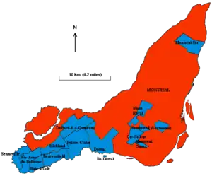
Island of Montreal
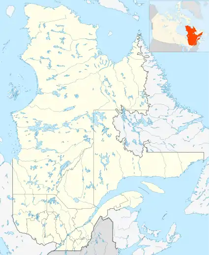
The Island of Montreal (French: Île de Montréal, Kanien’kéha (Mohawk): Tiohtià:ke), in southwestern Quebec, Canada, is the site of the city of Montreal. It is located at the confluence of the Saint Lawrence and Ottawa rivers. It is separated from Île Jésus (Laval) by the Rivière des Prairies.[6][7]
 Map of the Island of Montreal | |
 Island of Montréal[4] | |
| Geography | |
|---|---|
| Location | Saint Lawrence River |
| Coordinates | 45°30′01″N 73°38′47″W |
| Archipelago | Hochelaga Archipelago |
| Area | 499.19 km2 (192.74 sq mi) |
| Length | 50 km (31 mi) |
| Width | 16 km (9.9 mi) |
| Highest elevation | 233 m (764 ft) |
| Highest point | Mount Royal |
| Administration | |
Canada | |
| Province | Quebec |
| City | Montréal |
| Demographics | |
| Population | 1,942,044 (2016[5]) |
| Pop. density | 3,890/km2 (10080/sq mi) |
| Ethnic groups | multiracial (200 ethnic groups) |
Physical geography
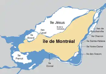
The island is approximately 50 km (30 miles) long and 16 km (10 miles) wide at its widest point, and has a shoreline of 266 km (165 miles). It is the second largest island in the Saint Lawrence River, after Anticosti Island in the Gulf of Saint Lawrence. The Island of Montreal is the largest island in the Hochelaga Archipelago, which is formed by the confluence of the Ottawa and St. Lawrence rivers.
The St. Lawrence widens into Lake Saint-Louis southwest of the island, narrows into the Lachine Rapids, then widens again into the Bassin de La Prairie before narrowing again and flowing toward Quebec City and the Atlantic Ocean. Saint Helen's Island and Notre Dame Island are in the Saint Lawrence southeast of downtown Montreal, and Nuns' Island is located southwest of downtown. The river forms the Lachine Rapids to the west of the island between Lake Saint-Louis and the Bassin de La Prairie, and the Rapides Sainte-Marie between the island and Saint Helen's Island. The Ottawa widens and becomes Lac des Deux-Montagnes north-west of the island. Natural watercourses on either side of Île Perrot, as well as the Sainte-Anne-de-Bellevue Canal on the western tip of the Island of Montréal, connect Lac des Deux-Montagnes and Lake Saint-Louis. Another outlet of Lac des Deux-Montagnes, the Rivière des Prairies, flows along the north shore of the island, separating it from Île Bizard and Île Jésus, and flows into the St. Lawrence at the northeastern tip of the Island of Montreal, while the Rivière des Mille-Îles separates Île Jésus from the northern mainland.
Man has altered the topography of the island significantly, as evidenced by historical maps that name a lake St. Pierre in the island. [8] This lake, and several other watercourses, have been drained or covered over as the city developed, while areas on the island's shores have been reclaimed and extended. The southwest of the island is separated by the Lachine Canal between Lachine and Montreal's Old Port; this portion of the island is partially divided further by the Canal de l'Aqueduc, running roughly parallel to the Lachine Canal, beginning in the borough of LaSalle and continuing between the boroughs of Le Sud-Ouest and Verdun.
Most of the bedrock of the island consists of Chazy limestone, with some Utica shale. At the centre of the island stand the three peaks of Mount Royal, a volcanic intrusion (not an extinct volcano, contrary to popular belief). This short mountain (elevation 233 metres, 765') is a member of, and gives its name to, the Monteregian Hills.
Human geography
The island of Montreal is the major component of the territory of the city of Montreal, along with Île Bizard, Saint Helen's Island, Notre Dame Island, Nuns' Island, and some 69 smaller islands. With a population of 2,014,221 inhabitants (22% of the population of Québec), it is by far the most populous island in Canada. It is also the 6th most populous island of the Americas and the 37th most populated island on Earth, outranking Manhattan Island in New York City. In addition, it is the world's most populous island surrounded by fresh water. Montreal and the other municipalities on the island compose the administrative region of Montréal. The area of the Urban agglomeration of Montreal, which includes the Island of Montreal and several other smaller islands, is 499 km² (193 sq. mi.).[9]
The crossings which connect the island to its surroundings are some of the busiest bridges in the country and the world. The Champlain Bridge and the Jacques Cartier Bridge together accommodate 101 million vehicle crossings a year.[10]
Name
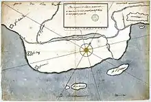
The first French name for the island was l'ille de Vilmenon, noted by Samuel de Champlain in a 1616 map, and derived from the sieur de Vilmenon, a patron of the founders of Quebec at the court of Louis XIII. However, by 1632 Champlain referred to the Isle de Mont-real in another map. The island derived its name from Mount Royal (French Mont Royal, then pronounced [mɔ̃rwɛjal]), and gradually spread its name to the town, which had originally been called Ville-Marie.
In the Kanien’kéha, the island is called Tiohtià:ke Tsi (a name referring to the Lachine Rapids to the island's southwest) or Ka-wé-no-te. In Anishninaabemowin, the land is called Mooniyaang (borrowed from the French word for the city).
Municipalities
Demographics
| 1876 | 1890 | 1931 | 1941 | 1951 | 1961 | 1971 | 1981 | 1991 | 1996 | 2001 | 2006 | 2011 |
|---|---|---|---|---|---|---|---|---|---|---|---|---|
| est. 120,000[11] | est. 200,000[11] | 1,003,868[12] | 1,116,800[12] | 1,320,232[12] | 1,747,696[13] | 1,959,180[13] | 1,760,122[13] | 1,775,871[13] | 1,775,846[14] |
1,812,723[15] |
1,854,442[15] | 1,886,481[16] |

See also
- List of islands of Quebec
- List of rivers and water bodies of Montreal Island
Note
- Although technically an island itself, Dorval Island is one of the 16 municipalities that makes up the island of Montreal.
References
- "Montréal Island".
- "Montréal Island".
- "Montréal Island".
- "Montréal Island".
- "2016 Census Profile - Montréal, Territoire équivalent (Census division)". Statistics Canada. 2017-02-08. Retrieved 2017-03-23.
- nationsonline.org, klaus kästle. "Google Map of the City of Montréal - Nations Online Project". Nationsonline.org. Retrieved 21 December 2017.
- Archived 2008-10-21 at the Wayback Machine
- "Following Rivière St. Pierre". Author Andrew Emond.
- Archived 2006-11-22 at the Wayback Machine
- Jacques Cartier Bridge: 43 million Archived 2006-09-25 at the Wayback Machine + Champlain Bridge: 58 million Archived 2008-06-25 at the Wayback Machine
- Aljaska en de Canada-spoorweg by Anonymous (in Dutch).
- "Vol. 1 - Table 2" (XLS). 1951 Canadian Census. University of Toronto. Retrieved 20 May 2008.
- "Statistical Tables - Religion". Statistics Canada Census. Gouvernement du Québec. Retrieved 20 May 2008.
- "Population and Dwelling Counts, for Canada, Provinces and Territories, and Census Divisions, 2001 and 1996 Censuses - 100% Data". Statistics Canada, 2001 Census of Population. Retrieved 13 March 2007.
- "Population and dwelling counts, for Canada, provinces and territories, and census divisions, 2006 and 2001 censuses - 100% data". Statistics Canada, 2006 Census of Population. 13 March 2007. Retrieved 13 March 2007.
- "Census Profile - Census Division - Montreal (ET)". Canada 2011 Census. Statistics Canada. 2012-07-30. Retrieved 16 September 2012.
Further reading
- Adams, Frank D., and O. E. LeRoy. The Artesian and Other Deep Wells on the Island of Montreal. Montreal: [s.n.], 1906. ISBN 0-665-72208-7
- Bosworth, Newton. Hochelaga Depicta The Early History and Present State of the City and Island of Montreal. Toronto: Coles Pub. Co, 1974. (Table of Contents)
- Fisher, John. Memorial in Support of the Petition of the Inhabitants and Proprietors of the City and Island of Montreal Praying That the Ecclesiastics of St. Sulpice May Not Be Constituted a Body Corporate and Ecclesiastical, and Their Title Confirmed to Certain Valuable Seigniories and Estates. Montreal?: s.n, 1840. ISBN 0-665-64087-0
- Mackay, Murdo. The Language Problem and School Board Reform on the Island of Montreal. Ottawa: National Library of Canada, 1988. ISBN 0-315-38290-2
- Parks Canada. Montréal, a City Steeped in History Guide to Nationality Significant Places, Persons and Events on the Island of Montréal. Québec: Parks Canada, 2004. ISBN 0-660-19274-8
- Russell, Ken. Metropolitan Government on the Island of Montreal. Toronto: Osgoode Hall Law School, 1972.
- Sancton, Andrew. Governing the Island of Montreal Language Differences and Metropolitan Politics. Lane studies in regional government. Berkeley: University of California Press, 1985. ISBN 0-520-04906-3
- Savoie, Josée. Neighbourhood Characteristics and the Distribution of Crime on the Island of Montréal. Crime and justice research paper series, no. 007. Ottawa: Statistics Canada, 2006. ISBN 0-662-43395-5
- Stansfield, John. The Pleistocene and Recent Deposits of the Island of Montreal. Ottawa: Government Printing Bureau, 1915.
External links
| Authority control |
|
|---|