J. N. "Ding" Darling National Wildlife Refuge
The J. N. "Ding" Darling National Wildlife Refuge is part of the United States National Wildlife Refuge System, located in southwestern Florida, on Sanibel Island in the Gulf of Mexico. "Ding" Darling Wildlife Society (DDWS), a non-profit Friends of the Refuge organization, supports environmental education and services at the J.N. "Ding" Darling National Wildlife Refuge.[1] It is named after the cartoonist Jay Norwood "Ding" Darling.[2]
| J.N. 'Ding' Darling National Wildlife Refuge | |
|---|---|
IUCN category IV (habitat/species management area) | |
 | |
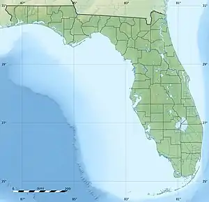  | |
| Location | Lee County, Florida, United States |
| Nearest city | Sanibel, Florida |
| Coordinates | 26°27′30″N 82°06′00″W |
| Area | 5200 acres (21 km2) |
| Established | 1976 |
| Named for | Jay Norwood "Ding" Darling |
| Governing body | US Fish & Wildlife Service |
| Website | J. N. "Ding" Darling National Wildlife Refuge |
History and description
The 5200 acre (21 km2) refuge was established in 1976, to protect one of the country's largest undeveloped mangrove ecosystems.
The J. N. "Ding" Darling National Wildlife Refuge Complex consists of the following: the Darling Refuge itself, and the Caloosahatchee, Island Bay, Matlacha, and Pine Island National Wildlife Refuges.
The northern section of the refuge is in the J.N. Ding Darling Wilderness Area, which was created in 1976 and currently protects 2,619 acres (1,060 ha) or 41% of the refuge.[3]
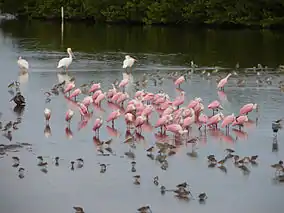
The refuge is well known for its migratory bird populations and birdwatching opportunities. It also home to raccoons, bobcats, river otters, alligators, and marsh rabbits.[3][4]
Climate impacts
Hurricane Charley struck the refuge on August 13, 2004, causing major changes to the topography and ecology.
Sea level rise has increased beach erosion on the barrier islands which protect Ding Darling's manatee habitat. Rising temperatures are increasing the ratio of female hatchlings of Ding Darling's endangered Florida loggerhead turtle population. The refuge's American alligator population is decreasing, due to increased salinity and a reduction of the freshwater flow in its mangroves.[4]

References
- "Partnerships - J.N. Ding Darling - U.S. Fish and Wildlife Service". www.fws.gov. Retrieved 2018-04-12.
- ""Ding" Darling Wildlife Society". dingdarlingsociety.org. Retrieved 2018-04-12.
- "J.N. "Ding" Darling Wilderness". Wilderness.net. Archived from the original on 2016-03-03. Retrieved 2011-08-22.
- Defenders of Wildlife (2020). "Climate Change and J.N. "Ding" Darling NWR". LandScope America. Retrieved 2020-02-26.
External links
 Media related to Ding Darling National Wildlife Refuge at Wikimedia Commons
- J.N. 'Ding' Darling National Wildlife Refuge at U.S. Fish and Wildlife Service
- 'Ding' Darling Wildlife Society
- J.N. 'Ding' Darling National Wildlife Refuge at J. N. 'Ding' Darling Foundation
- J.N. 'Ding' Darling National Wildlife Refuge at Florida Fish and Wildlife Conservation Commission
- J.N. 'Ding' Darling National Wildlife Refuge at Gorp.com
| Authority control |
|---|