Jambyl Region
Jambyl Region (Kazakh: Жамбыл облысы, romanized: Jambyl oblysy, جامبىل وبلىسى) is a region of Kazakhstan. Its capital is Taraz. The population of the region is 1,000,000; the city is 335,100. The region borders Kyrgyzstan, and is very near to Uzbekistan (all to the south). Jambyl also borders three other provinces: Karaganda Region (to the north), Turkistan Region (to the west) and Almaty Region (to the east). The total area is 144,200 square kilometres (55,700 sq mi). The province borders Lake Balkhash to its northeast. The province (and its capital during the Soviet era) was named after the Kazakh akyn (folk singer) Jambyl Jabayev.
Jambyl Region
Jambyl oblysy Жамбыл облысы | |
|---|---|
 | |
 Coat of arms | |
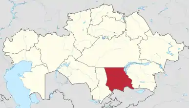 Map of Kazakhstan, location of Jambyl Province highlighted | |
| Coordinates: 44°0′N 72°0′E | |
| Country | |
| Capital | Taraz |
| Government | |
| • Akim | Karim Kokirekbaev |
| Area | |
| • Total | 144,264 km2 (55,701 sq mi) |
| Population (2013-02-01)[2] | |
| • Total | 1,071,645 |
| • Density | 7.4/km2 (19/sq mi) |
| Time zone | UTC+6 (East) |
| • Summer (DST) | UTC+6 (not observed) |
| Postal codes | 080000 |
| Area codes | +7 (726) |
| ISO 3166 code | KZ-ZHA |
| Vehicle registration | 08, H |
| Districts | 10 |
| Cities | 4 |
| Villages | 367 |
| Website | www |
Demographics
As of 2020, the Jambyl Region has a population of 1,130,099.[3]
Ethnic groups (2020):[4]
Administrative divisions
The province is administratively divided into ten districts and the city of Taraz.[5]
- Bayzak District, with the administrative center in the auyl of Sarykemer;
- Jambyl District, the auyl of Asy;
- Korday District, the auyl of Korday;
- Merki District, the auyl of Merki;
- Moiynkum District, the auyl of Moiynkum;
- Sarysu District, the town of Janatas;
- Shu District, the auyl of Tole bi;
- Talas District, the town of Karatau;
- Turar Ryskulov District, the auyl of Kulan;
- Zhualy District, the auyl of Bauyrzhan Momyshuly.
Janatas, Karatau, Shu, and Taraz have the administrative status of a town.[5]
Economy
Important industries include rock phosphate mining (around Karatau). The Chu River valley is one of Kazakhstan's important areas of irrigated agriculture.
The core of the rail transportation network in the region is based on the east-west Turksib rail line, which runs through Taraz and Chu toward Almaty, and the north-south Transkazakhstan line, which runs north from Chu toward Nur-Sultan. CIS Highway M 39 (which in this area forms part of European route E40) comes from Tashkent, Uzbekistan over Shymkent (capital of neighbouring province South Kazakhstan) and runs further over Taraz to Bishkek, Kyrgyzstan; then it comes to Jambyl Province again through Korday border crossing and continues east toward Almaty.
Gallery
 In the steppe north of the town of Shu
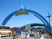 Entering Kazakhstan (and Jambyl Province) via Korday Bridge over the Chu
See also
References
- Official site - General Information Archived 2008-02-05 at the Wayback Machine
- Agency of statistics of the Republic of Kazakhstan: Численность населения Республики Казахстан по областям с начала 2013 года до 1 февраля 2013 года (russisch; Excel-Datei; 55 kB).
- "Численность населения Республики Казахстан по отдельным этносам на начало 2020 года". Stat.kz. Retrieved 2020-08-03.
- "Численность населения Республики Казахстан по отдельным этносам на начало 2020 года". Stat.kz. Retrieved 2020-08-03.
- "Характеристика" (in Russian). The official portal of akimat of Jambyl Region. Retrieved 13 July 2013.
External links
Places adjacent to Jambyl Region | ||||||||||
|---|---|---|---|---|---|---|---|---|---|---|
| ||||||||||
Capital: Taraz | ||
| Districts |  | |
| Major cities | ||
| Authority control |
|---|