Julita, Leyte
Julita, officially the Municipality of Julita (Waray: Bungto han Julita; Tagalog: Bayan ng Julita), is a 5th class municipality in the province of Leyte, Philippines. According to the 2015 census, it has a population of 15,114 people. [3]
Julita | |
|---|---|
| Municipality of Julita | |
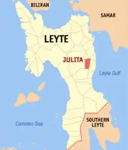 Map of Leyte with Julita highlighted | |
OpenStreetMap 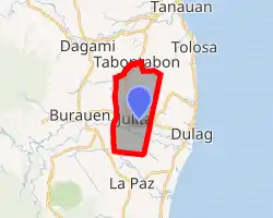
| |
.svg.png.webp) Julita Location within the Philippines | |
| Coordinates: 10°58′N 124°58′E | |
| Country | |
| Region | Eastern Visayas (Region VIII) |
| Province | Leyte |
| District | 2nd district of Leyte |
| Barangays | 26 (see Barangays) |
| Government | |
| • Type | Sangguniang Bayan |
| • Mayor | Percival S. Caña |
| • Vice Mayor | German J. Macaso |
| • Representative | Lolita T. Javier |
| • Councilors | List
|
| • Electorate | 11,463 voters (2019) |
| Area | |
| • Total | 53.30 km2 (20.58 sq mi) |
| Elevation | 39 m (128 ft) |
| Population | |
| • Total | 15,114 |
| • Density | 280/km2 (730/sq mi) |
| • Households | 3,806 |
| Economy | |
| • Income class | 5th municipal income class |
| • Poverty incidence | 33.24% (2015)[4] |
| • Revenue | ₱53,889,315.74 (2016) |
| Time zone | UTC+8 (PST) |
| ZIP code | 6506 |
| PSGC | |
| IDD : area code | +63 (0)53 |
| Climate type | tropical rainforest climate |
| Native languages | Waray Tagalog |
Julita is 47 kilometers from Tacloban, the capital city of Eastern Visayas. It is located between the municipalities of Dulag and Burauen.
The municipality of Julita was created through presidential executive order 278 under President Elpidio Quirino. Making it the second town after La Paz that parted its way to become independent from its maiden town Burauen.
Agriculture is the main industry in the area, especially rice and coconut production. About 70% of the working population is engaged in agriculture. Most live below the poverty line, and many lack basic necessities of life.[5]
Barangays
Julita is politically subdivided into 26 barangays. [2]
- Alegria
- Anibong
- Aslum
- Balante
- Bongdo
- Bonifacio
- Bugho
- Calbasag
- Caridad
- Cuya-e
- Dita
- Gitabla
- Hindang
- Inawangan
- Jurao
- Poblacion District I
- Poblacion District II
- Poblacion District III
- Poblacion District IV
- San Andres
- San Pablo
- Santa Cruz
- Santo Niño
- Tagkip
- Tolosahay
- Villa Hermosa
Climate
| Climate data for Julita, Leyte | |||||||||||||
|---|---|---|---|---|---|---|---|---|---|---|---|---|---|
| Month | Jan | Feb | Mar | Apr | May | Jun | Jul | Aug | Sep | Oct | Nov | Dec | Year |
| Average high °C (°F) | 28 (82) |
28 (82) |
29 (84) |
30 (86) |
30 (86) |
30 (86) |
29 (84) |
29 (84) |
29 (84) |
29 (84) |
29 (84) |
28 (82) |
29 (84) |
| Average low °C (°F) | 22 (72) |
22 (72) |
22 (72) |
23 (73) |
25 (77) |
25 (77) |
25 (77) |
25 (77) |
25 (77) |
24 (75) |
24 (75) |
23 (73) |
24 (75) |
| Average precipitation mm (inches) | 78 (3.1) |
57 (2.2) |
84 (3.3) |
79 (3.1) |
118 (4.6) |
181 (7.1) |
178 (7.0) |
169 (6.7) |
172 (6.8) |
180 (7.1) |
174 (6.9) |
128 (5.0) |
1,598 (62.9) |
| Average rainy days | 16.7 | 13.8 | 17.3 | 18.5 | 23.2 | 26.5 | 27.1 | 26.0 | 26.4 | 27.5 | 24.6 | 21.0 | 268.6 |
| Source: Meteoblue [6] | |||||||||||||
Demographics
|
| |||||||||||||||||||||||||||||||||
| Source: Philippine Statistics Authority [3] [7] [8][9] | ||||||||||||||||||||||||||||||||||
In the 2015 census, the population of Julita, Leyte, was 15,114 people, [3] with a density of 280 inhabitants per square kilometre or 730 inhabitants per square mile.
References
- Municipality of Julita | (DILG)
- "Province: Leyte". PSGC Interactive. Quezon City, Philippines: Philippine Statistics Authority. Retrieved 12 November 2016.
- Census of Population (2015). "Region VIII (Eastern Visayas)". Total Population by Province, City, Municipality and Barangay. PSA. Retrieved 20 June 2016.
- "PSA releases the 2015 Municipal and City Level Poverty Estimates". Quezon City, Philippines. Retrieved 12 October 2019.
- "Julita, Leyte". "https://wordsimilarity.com". Retrieved January 24, 2019.
- "Julita: Average Temperatures and Rainfall". Meteoblue. Retrieved 9 February 2020.
- Census of Population and Housing (2010). "Region VIII (Eastern Visayas)". Total Population by Province, City, Municipality and Barangay. NSO. Retrieved 29 June 2016.
- Censuses of Population (1903–2007). "Region VIII (Eastern Visayas)". Table 1. Population Enumerated in Various Censuses by Province/Highly Urbanized City: 1903 to 2007. NSO.
- "Province of Leyte". Municipality Population Data. Local Water Utilities Administration Research Division. Retrieved 17 December 2016.
External links
- Julita Profile at PhilAtlas.com
- Philippine Standard Geographic Code
- Philippine Census Information
- Local Governance Performance Management System
Tacloban (capital) | |
| Municipalities |
|
| Component city | |
| Independent component city |
|
| Highly urbanized city |
|
| Authority control |
|---|