Tabontabon
Tabontabon, officially the Municipality of Tabontabon (Waray: Bungto han Tabontabon; Tagalog: Bayan ng Tabontabon), is a 5th class municipality in the province of Leyte, Philippines. According to the 2015 census, it has a population of 11,204 people. [3]
Tabontabon | |
|---|---|
| Municipality of Tabontabon | |
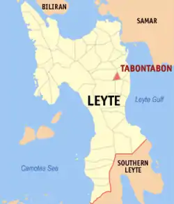 Map of Leyte with Tabontabon highlighted | |
OpenStreetMap 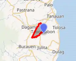
| |
.svg.png.webp) Tabontabon Location within the Philippines | |
| Coordinates: 11°02′N 124°58′E | |
| Country | |
| Region | Eastern Visayas (Region VIII) |
| Province | Leyte |
| District | 2nd District |
| Barangays | 16 (see Barangays) |
| Government | |
| • Type | Sangguniang Bayan |
| • Mayor | Efren D. Redoña |
| • Vice Mayor | Ponciano R. Justimbate Jr. |
| • Representative | Lolita T. Javier |
| • Councilors | List
|
| • Electorate | 8,838 voters (2019) |
| Area | |
| • Total | 24.18 km2 (9.34 sq mi) |
| Elevation | 23 m (75 ft) |
| Population | |
| • Total | 11,204 |
| • Density | 460/km2 (1,200/sq mi) |
| • Households | 2,774 |
| Economy | |
| • Income class | 5th municipal income class |
| • Poverty incidence | 37.36% (2015)[4] |
| • Revenue | ₱42,389,773.11 (2016) |
| Time zone | UTC+8 (PST) |
| ZIP code | 6504 |
| PSGC | |
| IDD : area code | +63 (0)53 |
| Climate type | tropical rainforest climate |
| Native languages | Waray Tagalog |
History
On October 17, 1953, Executive Order numbered 631 by the President carved out 11 barangays to form Tabontabon from the municipalities of Tanauan and Dagami.
On June 20, 1957, Republic Act numbered 1649, transferred barangays Capahu-an and Guingawan from the town of Dagami to Tabontabon.[5]
Barangays
Tabontabon is politically subdivided into 16 barangays. [2]
- Amandangay
- Aslum
- Balingasag
- Belisong
- Cambucao
- Capahuan
- Guingauan
- Jabong
- Mercaduhay
- Mering
- Mohon
- District I Pob. (Quezon)
- District II Pob. (Rizal)
- District III Pob. (Bonifacio)
- District IV Pob. (Macarthur)
- San Pablo (Mooc)
Climate
| Climate data for Tabontabon, Leyte | |||||||||||||
|---|---|---|---|---|---|---|---|---|---|---|---|---|---|
| Month | Jan | Feb | Mar | Apr | May | Jun | Jul | Aug | Sep | Oct | Nov | Dec | Year |
| Average high °C (°F) | 28 (82) |
29 (84) |
29 (84) |
30 (86) |
30 (86) |
30 (86) |
29 (84) |
29 (84) |
29 (84) |
29 (84) |
29 (84) |
29 (84) |
29 (84) |
| Average low °C (°F) | 22 (72) |
22 (72) |
22 (72) |
23 (73) |
25 (77) |
25 (77) |
25 (77) |
25 (77) |
25 (77) |
24 (75) |
24 (75) |
23 (73) |
24 (75) |
| Average precipitation mm (inches) | 78 (3.1) |
57 (2.2) |
84 (3.3) |
79 (3.1) |
118 (4.6) |
181 (7.1) |
178 (7.0) |
169 (6.7) |
172 (6.8) |
180 (7.1) |
174 (6.9) |
128 (5.0) |
1,598 (62.9) |
| Average rainy days | 16.7 | 13.8 | 17.3 | 18.5 | 23.2 | 26.5 | 27.1 | 26.0 | 26.4 | 27.5 | 24.6 | 21.0 | 268.6 |
| Source: Meteoblue [6] | |||||||||||||
Demographics
|
| ||||||||||||||||||||||||||||||||||||
| Source: Philippine Statistics Authority [3] [7] [8][9] | |||||||||||||||||||||||||||||||||||||
In the 2015 census, the population of Tabontabon was 11,204 people, [3] with a density of 460 inhabitants per square kilometre or 1,200 inhabitants per square mile.
Tabontabon is a 100% Waray-Waray speaking municipality.
References
- Municipality of Tabontabon | (DILG)
- "Province: Leyte". PSGC Interactive. Quezon City, Philippines: Philippine Statistics Authority. Retrieved 12 November 2016.
- Census of Population (2015). "Region VIII (Eastern Visayas)". Total Population by Province, City, Municipality and Barangay. PSA. Retrieved 20 June 2016.
- "PSA releases the 2015 Municipal and City Level Poverty Estimates". Quezon City, Philippines. Retrieved 12 October 2019.
- "An Act Transferring the Barrios of Capahu-an and Guingawan, Municipality of Dagami, Province of Leyte, to the Municipality of Tabontabon". LawPH.com. Retrieved 2011-04-12.
- "Tabontabon: Average Temperatures and Rainfall". Meteoblue. Retrieved 29 February 2020.
- Census of Population and Housing (2010). "Region VIII (Eastern Visayas)". Total Population by Province, City, Municipality and Barangay. NSO. Retrieved 29 June 2016.
- Censuses of Population (1903–2007). "Region VIII (Eastern Visayas)". Table 1. Population Enumerated in Various Censuses by Province/Highly Urbanized City: 1903 to 2007. NSO.
- "Province of Leyte". Municipality Population Data. Local Water Utilities Administration Research Division. Retrieved 17 December 2016.
External links
- Tabontabon Profile at PhilAtlas.com
- Philippine Standard Geographic Code
- Philippine Census Information
- Local Governance Performance Management System
Tacloban (capital) | |
| Municipalities |
|
| Component city | |
| Independent component city |
|
| Highly urbanized city |
|
