Calubian
Calubian, officially the Municipality of Calubian (Cebuano: Lungsod sa Calubian; Waray: Bungto han Calubian; Tagalog: Bayan ng Calubian), is a 4th class municipality in the province of Leyte, Philippines. According to the 2015 census, it has a population of 31,228 people. [3]
Calubian | |
|---|---|
| Municipality of Calubian | |
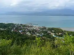 Hilltop view of Calubian | |
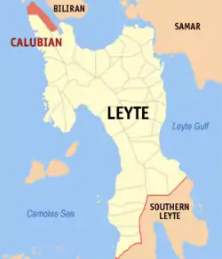 Map of Leyte with Calubian highlighted | |
OpenStreetMap 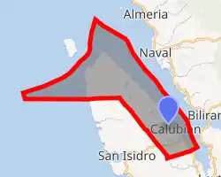
| |
.svg.png.webp) Calubian Location within the Philippines | |
| Coordinates: 11°27′N 124°25′E | |
| Country | |
| Region | Eastern Visayas (Region VIII) |
| Province | Leyte |
| District | 3rd District |
| Barangays | 53 (see Barangays) |
| Government | |
| • Type | Sangguniang Bayan |
| • Mayor | Marciano A. Batiancela Jr. |
| • Vice Mayor | Gilbert S. Ponce |
| • Representative | Vicente Sofronio E. Veloso III |
| • Councilors | List
|
| • Electorate | 23,596 voters (2019) |
| Area | |
| • Total | 100.95 km2 (38.98 sq mi) |
| Elevation | 82 m (269 ft) |
| Population | |
| • Total | 31,228 |
| • Density | 310/km2 (800/sq mi) |
| • Households | 7,796 |
| Economy | |
| • Income class | 4th municipal income class |
| • Poverty incidence | 40.48% (2015)[4] |
| • Revenue | ₱80,836,473.98 (2016) |
| Time zone | UTC+8 (PST) |
| ZIP code | 6534 |
| PSGC | |
| IDD : area code | +63 (0)53 |
| Climate type | tropical rainforest climate |
| Native languages | Cebuano Tagalog |
Barangays
Calubian is politically subdivided into 53 barangays.
- Abanilla
- Anislagan
- Bunacan
- Cabalquinto
- Herrera (Cabalhin)
- Cabradilla
- Caneja
- Cantonghao
- Caroyocan
- Casiongan
- Cristina
- Dalumpines
- Don Luis
- Dulao
- Efe (Ul-og)
- Enage
- Espinosa
- Ferdinand E. Marcos
- Garganera
- Garrido
- Guadalupe
- Gutosan
- Igang
- Inalad
- Jubay
- Juson
- Kawayan Bogtong
- Kawayanan
- Kokoy Romualdez
- Labtic
- Laray
- Limite (Agas)
- Manuel Veloso
- Mahait
- Malobago
- Matagok
- Nierras
- Nipa
- Obispo
- Pagatpat
- Pangpang
- Patag
- Pates
- Pal-og
- Padoga
- Petrolio
- Poblacion
- Railes
- Tabla
- Tagharigue
- Tuburan
- Villahermosa
- Villalon
- Villanueva
Climate
| Climate data for Calubian, Leyte | |||||||||||||
|---|---|---|---|---|---|---|---|---|---|---|---|---|---|
| Month | Jan | Feb | Mar | Apr | May | Jun | Jul | Aug | Sep | Oct | Nov | Dec | Year |
| Average high °C (°F) | 28 (82) |
29 (84) |
29 (84) |
31 (88) |
31 (88) |
30 (86) |
30 (86) |
30 (86) |
30 (86) |
29 (84) |
29 (84) |
29 (84) |
30 (85) |
| Average low °C (°F) | 22 (72) |
22 (72) |
22 (72) |
23 (73) |
24 (75) |
25 (77) |
25 (77) |
25 (77) |
25 (77) |
24 (75) |
24 (75) |
25 (77) |
24 (75) |
| Average precipitation mm (inches) | 73 (2.9) |
56 (2.2) |
75 (3.0) |
71 (2.8) |
114 (4.5) |
174 (6.9) |
172 (6.8) |
163 (6.4) |
167 (6.6) |
161 (6.3) |
158 (6.2) |
125 (4.9) |
1,509 (59.5) |
| Average rainy days | 15.2 | 12.5 | 16.2 | 17.3 | 23.9 | 27.3 | 28.4 | 26.9 | 26.9 | 27.1 | 23.8 | 19.3 | 264.8 |
| Source: Meteoblue (Use with caution: this is modeled/calculated data, not measured locally.) [5] | |||||||||||||
History
On January 8, 1919, Governor Charles E. Yeater issued Executive Order No. 4, creating the town of Calubian which is formerly a barrio of the Municipality of Leyte, Leyte. Originally, its name was Eulalia in honor of a prominent lady resident. Later it was changed to Calubian due to the vast coconut plantation of the place (Photo shown is the Eulalia Monument located at the foot of the Veloso hill on the way to the Municipal Hall).
The Local Government of Calubian was formerly organized on January 22, 1919 with Felix Garganera as its first town executive. In 1922, he was succeeded by Nepumoceno Torlao, a generous resident of the locality. Then Alejandro Baronda took the reign as Local Chief Executive from 1931 to 1934. From 1934 to 1937, Felix Lafuente became the Town Chief followed by Francisco Enage in 1938 to 1940 and later on Enrique Q. Enage led the town from 1941 to 1942. They were followed by Lorenzo Mendoza from 1942 to 1944. Honorato Agas Sr led his people from 1945 to April 15, 1986 except for one term 1952-1953 when he was defeated by Rosendo Eamiguel, a popular landlord of Barangay Villalon.
The popular EDSA Revolution on February 25, 1986 brought an end to Agas’ term and Victorio Loygos Sr was eventually appointed as the OIC Mayor from April 16, 1986 to May 1987. Engr. Rolando R. Amparado succeeded him by appointment from June 24, 1987 to November 30, 1987 followed by Marciano Batiancela Jr from December 1, 1987 until the newly elected Local Chief Executive in the person of Dr. Carlos C. Cotiangco Jr. assumed office on February 8, 1988. He has done tremendous accomplishment in the Metro-Calubian by accomplishing several infrastructure projects such as concreting of municipal and barangay roads, public markets, waiting sheds, completion of municipal hall, improvement of the drainage system , multi-purpose pavements and water works projects.[6]
Demographics
|
| ||||||||||||||||||||||||||||||||||||||||||
| Source: Philippine Statistics Authority [3] [7] [8][9] | |||||||||||||||||||||||||||||||||||||||||||
In the 2015 census, the population of Calubian, Leyte, was 31,228 people, [3] with a density of 310 inhabitants per square kilometre or 800 inhabitants per square mile.
Gallery
|


References
- Municipality of Calubian | (DILG)
- "Province: Leyte". PSGC Interactive. Quezon City, Philippines: Philippine Statistics Authority. Retrieved 12 November 2016.
- Census of Population (2015). "Region VIII (Eastern Visayas)". Total Population by Province, City, Municipality and Barangay. PSA. Retrieved 20 June 2016.
- "PSA releases the 2015 Municipal and City Level Poverty Estimates". Quezon City, Philippines. Retrieved 12 October 2019.
- "Calubian: Average Temperatures and Rainfall". Meteoblue. Retrieved 9 February 2020.
- "BRIEF HISTORY OF CALUBIAN". calubiansite.blogspot.com. Retrieved January 15, 2019.
- Census of Population and Housing (2010). "Region VIII (Eastern Visayas)". Total Population by Province, City, Municipality and Barangay. NSO. Retrieved 29 June 2016.
- Censuses of Population (1903–2007). "Region VIII (Eastern Visayas)". Table 1. Population Enumerated in Various Censuses by Province/Highly Urbanized City: 1903 to 2007. NSO.
- "Province of Leyte". Municipality Population Data. Local Water Utilities Administration Research Division. Retrieved 17 December 2016.
External links
| Wikimedia Commons has media related to Calubian. |
- Calubian Profile at PhilAtlas.com
- Philippine Standard Geographic Code
- Official website of the Municipality of Calubian
- Local Governance Performance Management System
Places adjacent to Calubian | ||||||||||
|---|---|---|---|---|---|---|---|---|---|---|
| ||||||||||
Tacloban (capital) | |
| Municipalities |
|
| Component city | |
| Independent component city |
|
| Highly urbanized city |
|