Kōhoku, Saga
Kōhoku (江北町, Kōhoku-machi) is a town located in Kishima District, Saga Prefecture, Japan. It is known as a crossroads for railways and national highways, and as such has dubbed itself "the navel of Saga".
Kōhoku
江北町 | |||||||||||
|---|---|---|---|---|---|---|---|---|---|---|---|
Town | |||||||||||
 View of Kōhoku Town | |||||||||||
 Flag  Emblem | |||||||||||
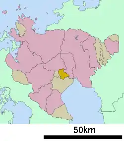 Location of Kōhoku in Saga Prefecture | |||||||||||
 Kōhoku Location in Japan | |||||||||||
| Coordinates: 33°13′N 130°9′E | |||||||||||
| Country | Japan | ||||||||||
| Region | Kyushu | ||||||||||
| Prefecture | Saga Prefecture | ||||||||||
| District | Kishima | ||||||||||
| Government | |||||||||||
| • Mayor | Kenichi Tanaka | ||||||||||
| Area | |||||||||||
| • Total | 24.48 km2 (9.45 sq mi) | ||||||||||
| Population (October 1, 2016) | |||||||||||
| • Total | 9,524 | ||||||||||
| • Density | 390/km2 (1,000/sq mi) | ||||||||||
| Time zone | UTC+09:00 (JST) | ||||||||||
| City hall address | 1651-1 Ōaza Yamaguchi, Kōhoku-chō, Kishima-gun, Saga-ken 849-0592 | ||||||||||
| Website | www | ||||||||||
| |||||||||||
Geography
- Mountains: The northern part of the city is gradually mountainous.
- Rivers: Rokkaku River, Ushizu River
History
- April 1, 1932 - The villages of Oda (小田村), Yamaguchi (山口村), and Sarushi (佐留志村) merge to form the village of Kōhoku.
- April 1, 1952- The village of Kōhoku gains town status.
- September 30, 1956 - Part of the village of Teisen (砥川村) from Ogi District merges with Kōhoku.
Education
- Kōhoku Junior High School (江北町立江北中学校)
- Kōhoku Elementary School (江北町立江北小学校)
Transportation
Air
- The closest airport is Saga Airport.
Rail
- Station(s): Hizen-Yamaguchi
- Lines: Nagasaki Main Line, Sasebo Line
- To Major Cities
- To Fukuoka, as well as the nearest Shinkansen station:
- To Nagasaki: About 1 hour and 10 minutes by limited express, about 2 hours and 10 minutes by local train
- To Sasebo: About 55 minutes by limited express, about 1 hour and 10 minutes by local train
Road
- Expressways: None
- National Highway: Route 34, Route 207
- Prefectural Roads: Saga Prefectural Route 35
External links
 Media related to Kōhoku, Saga at Wikimedia Commons
- Kōhoku official website (in Japanese)
| Special city | ||
|---|---|---|
| Cities | ||
| Districts | ||
| Authority control |
|---|
This article is issued from Wikipedia. The text is licensed under Creative Commons - Attribution - Sharealike. Additional terms may apply for the media files.