K-116 (Kansas highway)
K-116 is a 26.146-mile-long (42.078 km) state highway in the U.S. state of Kansas. K-116's western terminus is at U.S. Route 75 (US-75) and K-16 in Holton, and the eastern terminus is at US-59 southwest of Atchison. The first 3.5 miles (5.6 km) of K-116 is co-designated as K-16. Also a brief section is co-designated as US-159 near the eastern terminus. The highway travels mostly through rural farmlands and is a two-lane highway its entire length.
| ||||
|---|---|---|---|---|
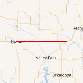
K-116 highlighted in red | ||||
| Route information | ||||
| Maintained by KDOT | ||||
| Length | 26.146 mi[1] (42.078 km) | |||
| Existed | January 7, 1937[2]–present | |||
| Major junctions | ||||
| West end | ||||
| ||||
| East end | ||||
| Location | ||||
| Counties | Jackson, Atchison | |||
| Highway system | ||||
| ||||

Before state highways were numbered in Kansas there were auto trails. The section between US-159 and the eastern terminus was part of the former South West Trail. The western terminus connects to the former Omaha-Topeka Trail, Capitol Route, and Corn Belt Route. K-116 was assigned on January 7, 1937. By January 1938, K-16 was realigned to run directly north to K-116, then run west along K-116 into Holton.
Route description
K-116 begins at an intersection with US-75 in Holton and begins travelling eastward along 4th Street concurrent with K-16. After slightly 1.3 miles (2.1 km) it exits Holton and crosses Banner Creek.[3] The two highways continue another two miles (3.2 km) through farmlands with scattered houses then intersects T Road. At this point K-16 turns south towards Birmingham and K-116 continues east. K-116 continues for roughly 1.6 miles (2.6 km) then crosses Bills Creek, a tributary of Elk Creek. The highway continues through small rolling hills covered with grasslands for 1.4 miles (2.3 km) and intersects West Road, which heads south to Denison. It continues eastward from here through more rolling hills for about three miles (4.8 km) and enters Larkinburg as it crosses into Atchison County.[4]

As K-116 enters the county the landscape around the highway flattens and transitions to farmlands. After about .75 miles (1.21 km) it crosses Elk Creek, a tributary of the Delaware River. The highway intersects Anderson Road then curves southeast briefly then back east. It crosses the Delaware River then passes to the south of Arrington. K-116 shifts back north then continues east for .8 miles (1.3 km) and intersects Bourbon Road, which runs north to Muscotah. The highway continues through farmlands for about 3 1⁄4 miles (5.2 km) and then crosses Coal Creek. It continues east, as more scattered areas of trees appear, for about 2 3⁄4 miles (4.4 km) then intersects Edwards Road. Edwards Road goes north to Effingham as K-116 continues east for another two miles (3.2 km) and then crosses Little Stranger Creek. The highway continues for about 1.1 miles (1.8 km) then is joined by US-159 from the north. The two routes continue east for roughly .7 miles (1.1 km), where US-159 turns back south. K-116 continues east through flat farmlands with scattered houses for roughly 3.8 miles (6.1 km) and then reaches its eastern terminus at US-59 southwest of Atchison and west of Cummings.[5]
The Kansas Department of Transportation (KDOT) tracks the traffic levels on its highways, and in 2019, they determined that on average the traffic varied from 610 vehicles per day slightly west of the overlap with US-159 to 2110 vehicles per day slightly east of Holton. The second highest was slightly east of the K-16 overlap and along the US-159 overlap at just over 1000 vehicles per day.[6] K-116 is not included in the National Highway System.[7] The National Highway System is a system of highways important to the nation's defense, economy, and mobility. K-116 does connect to the National Highway System at each terminus, US-75 and US-59.[8]
History
Before state highways were numbered in Kansas there were auto trails, which were an informal network of marked routes that existed in the United States and Canada in the early part of the 20th century. The section of K-116 between US-159 and the eastern terminus was part of the former South West Trail. The western terminus connects to the former Omaha-Topeka Trail, Capitol Route, and Corn Belt Route.[9]
K-116 was assigned by the Kansas Department of Transportation (KDOT), at the time State Highway Commission of Kansas, in a January 7, 1937 resolution. At that time it ran from its current western terminus to the western end of the overlap with US-159.[2] Also in another January 7, 1937 resoulion, it was approved to realign K-16 to run directly north to K-116, then run west along K-116 into Holton.[10] This realignment of K-16 was complete by January 1938. Then on August 7, 1941, K-116 was realigned slightly near the crossing of Bills Creek to eliminate six dangerous curves.[11] In a July 10, 1957 resolution, it was approved to realign US-59 and K-4 between Nortonville and Cummings.[12] This new section opened up to traffic on August 30, 1958.[13] On June 10, 1967, a 1.5-mile (2.4 km) section of K-116 was closed between Arrington and Larkinburg due to flooding from the Delaware River, which covered the roadway.[14] Then again in late December 1972, a section was temporarily closed due to flooding from the Delaware River.[15]
Major intersections
| County | Location | mi[1] | km | Destinations | Notes |
|---|---|---|---|---|---|
| Jackson | Holton | 0.000 | 0.000 | Continuation past US-75; western end of K-16 concurrency | |
| Western terminus; US-75 serves Holton Community Hospital | |||||
| Franklin–Garfield township line | 3.506 | 5.642 | Eastern end of K-16 concurrency | ||
| Atchison | Center Township | 21.659 | 34.857 | Western end of US-159 concurrency | |
| 22.309 | 35.903 | Eastern end of US-159 concurrency | |||
| 26.146 | 42.078 | Eastern terminus | |||
1.000 mi = 1.609 km; 1.000 km = 0.621 mi
| |||||
References
- Staff (2016). "Pavement Management Information System". Topeka: Kansas Department of Transportation. Retrieved April 21, 2017.
- State Highway Commission of Kansas (January 7, 1937). "1937 Resolution". Topeka: State Highway Commission of Kansas. Retrieved October 24, 2020.
- Bureau of Transportation Planning (April 2007). City of Holton (PDF) (Map). Scale not given. KDOT City Maps. Topeka: Kansas Department of Transportation. Retrieved October 24, 2020.
- Bureau of Transportation Planning (January 2012). Jackson County (PDF) (Map). [c. 1: 211,200]. General Highway Map. Topeka: Kansas Department of Transportation. Retrieved October 24, 2020.
- Bureau of Transportation Planning (July 2011). Atchison County (PDF) (Map). [c. 1: 211,200]. General Highway Map. Topeka: Kansas Department of Transportation. Retrieved October 24, 2020.
- Bureau of Transportation Planning (2020). Traffic Flow Map Kansas State Highway System (PDF) (Map). [c. 1:1,584,000]. Topeka: Kansas Department of Transportation. Retrieved October 24, 2020.
- Federal Highway Administration (May 8, 2019). National Highway System: Kansas (PDF) (Map). [c. 1:3,900,000]. Washington, DC: Federal Highway Administration. Retrieved July 29, 2019.
- Natzke, Stefan; Neathery, Mike; Adderly, Kevin (September 26, 2012). "What is the National Highway System?". National Highway System. Washington, DC: Federal Highway Administration. Retrieved July 29, 2019.
- Rand McNally and Company (1924). "Kansas" (Map). AutoTrails Map, Southern Nebraska, Eastern Colorado, Kansas, Northeastern New Mexico, Northern Oklahoma. 1:1,600,000. Chicago: Rand McNally and Company. OCLC 2078375. Retrieved October 25, 2020 – via Rumsey Collection.
- State Highway Commission of Kansas (January 7, 1937). "Resolution for Relocation and Redesignation of Road in Jackson County". Topeka: State Highway Commission of Kansas. Retrieved August 23, 2019.
- State Highway Commission of Kansas (August 7, 1941). "Resolution for Relocation and Redesignation of Road in Jackson County". Topeka: State Highway Commission of Kansas. Retrieved August 23, 2019.
- State Highway Commission of Kansas (July 10, 1957). "Resolution for Relocation and Redesignation of Road in Atchison County". Topeka: State Highway Commission of Kansas. Retrieved August 25, 2019.
- "To Open US-59 Link August 30". The Winchester Star. Winchester, KS. August 29, 1958. p. 1. Retrieved October 26, 2020 – via Newspapers.com.
- "Rampaging Missouri Tops Flood Stage". The Atchison Daily Globe. Atchison, KS. June 11, 1967. p. 1. Retrieved October 25, 2020 – via Newspapers.com.
- "Flooding". The Atchison Daily Globe. Atchison, KS. December 31, 1972. p. 9. Retrieved October 25, 2020 – via Newspapers.com.