K-63 (Kansas highway)
K-63 is a 58.769-mile-long (94.580 km) state highway in the U.S. state of Kansas. It is a north-south highway that serves small towns in the northeast part of the state, connecting St. Marys to the Nebraska state border. K-63's southern terminus is at U.S. Route 24 (US-24) and the northern terminus is a continuation as Nebraska Highway 50 (N-50) at the Nebraska border. The highway passes mostly through rural farmlands, however it does pass through the cities of Emmett, Havensville and Corning. It also passes along the edge of Seneca, where it has a short overlap with US-36.
| ||||
|---|---|---|---|---|
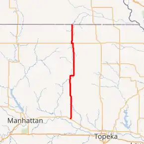
K-63 highlighted in red | ||||
| Route information | ||||
| Maintained by KDOT and the city of St. Marys | ||||
| Length | 58.769 mi[1] (94.580 km) | |||
| Existed | 1927[2]–present | |||
| Major junctions | ||||
| South end | ||||
| North end | ||||
| Location | ||||
| Counties | Nemaha, Pottawatomie | |||
| Highway system | ||||
| ||||

Before state highways were numbered in Kansas there were auto trails. The southern terminus was part of the former Roosevelt National Highway and Golden Belt. The former Corn Belt Highway crosses K-63 in Havensville. A small section just south of Seneca and a few sections between Seneca and Nebraska border follows the former Omaha-Topeka Trail. The highway also crosses the former Pikes Peak Ocean to Ocean Highway in Seneca. K-63 was first designated as a state highway in 1927. The highway has remained unchanged since, except for minor realignments by Emmett and Seneca.
Route description
The Kansas Department of Transportation (KDOT) tracks the traffic levels on its highways, and in 2019, they determined that on average the traffic varied from 475 vehicles per day between K-16 and Havensville to 4700 vehicles per day along the overlap with US-36. The second highest was 3720 vehicles per day between the southern terminus and Emmett.[3] The only section of K-63 included in the National Highway System is its overlap with US-36.[4] The National Highway System is a system of highways important to the nation's defense, economy, and mobility. K-63 also connects to the National Highway System at its southern terminus at US-24.[5] The section of K-63 in St. Marys from the southern terminus to just north of Elm Street is maintained by the city.[6]
Pottawatomie County
K-63 begins in St. Marys at US-24, also known as Bertrand Street. The highway crosses a Union Pacific Railway track then continues northeast through the city as 6th Street. It curves northward then exits the city and intersects Delia Road about two miles (3.2 km) later.[7] At this point the highway becomes more rural and continues north for 1.6 miles (2.6 km) through flat grasslands then crosses Bourbonais Creek. K-63 continues through flat grasslands with scattered areas of trees for 2.9 miles (4.7 km) then begins to run along the west side of Emmett.[8] After passing the city, the highway crosses Bartlett Creek then a Union Pacific Railway track. The highway continues for 3.6 miles (5.8 km) through flat rural farmlands, crosses Little Noxie Creek, then intersects St Clere Road, which travels east to St. Clere. It continues north for 1.2 miles (1.9 km) then shifts about 1⁄2 mile (0.80 km) west.[9][10]
K-63 continues through flat grasslands with scattered areas of trees for 4.5 miles (7.2 km) then is joined by K-16 from the east. The two highways continue for about one mile (1.6 km) then K-16 turns west toward Onaga. K-63 continues north through small rolling hills for about 1.25 miles (2.01 km) then curves slightly northwest. The highway continues a short distance, crosses Strait Creek, then enters Havensville as Commercial Street.[11] The highway exits the city and continues for 1.1 miles (1.8 km) then crosses Vermillion Creek. K-63 then shifts east briefly then continues north through open grasslands with scattered areas of trees. After about 1.7 miles (2.7 km) the highway curves east and begins to follow the Pottawatomie–Nemaha county line. The highway continues east for one mile (1.6 km), where it crosses Vermillion Creek again, then curves north into the county .7 miles (1.1 km) later.[9][10]
Nemaha County
K-63 continues north through flat rural farmlands transitioning to rolling hills for about 4.7 miles (7.6 km) then crosses Vermillion Creek again. The highway continues another roughly 1.2 miles (1.9 km) then is joined by K-9 from the east at the south city limits of Corning. The two highways continue north through the city as Seneca Street. After about 1⁄2 mile (0.80 km) the highway exits the city and passes by Corning Cemetery.[12] They continue north through rolling hills transitioning to flat farmlands for about 4.3 miles (6.9 km) then K-9 turns west towards Centralia. K-63 continues north for about 2.5 miles (4.0 km) then curves northwest and crosses South Fork Big Nemaha River. The highway then turns north and continues about 1.8 miles (2.9 km) then curves northwest and crosses Tennessee Creek. It curves back north and continues for 2.3 miles (3.7 km) then intersects US-36.[10][13]
K-63 turns west and begins to overlap US-36. The two routes soon cross a Union Pacific Railway track and then the South Fork Big Nemaha River again. They then reach the Seneca city limit, where K-63 turns north as US-36 continues west into the city.[14] The highway continues north for about 1.2 miles (1.9 km) then shifts east slightly and crosses Wildcat Creek. It continues north through flat rural farmlands for roughly 5.2 miles (8.4 km) and crosses Turkey Creek. The roadway continues a short distance then intersects K-71, which travels east to Bern. K-63 continues north for 2.8 miles (4.5 km) through more farmlands then crosses into Nebraska and becomes Nebraska Highway 50.[10][13]
History
Prior to the formation of the Kansas state highway system, there were auto trails, which were an informal network of marked routes that existed in the United States and Canada in the early part of the 20th century. The southern terminus was part of the former Roosevelt National Highway and Golden Belt. The former Corn Belt Highway crosses K-63 in Havensville. A small section just south of Seneca and a few sections between Seneca and Nebraska border follows the former Omaha-Topeka Trail. The highway also crosses the former Pikes Peak Ocean to Ocean Highway in Seneca.[15]
K-63 was first designated as a state highway in 1927, to a highway running from US-40 in St. Marys north to the Nebraska border.[2] K-16 was originally K-24 but was renumbered to K-16 between April 1933 and April 1936, due to US-24 being extended into Kansas. Also at this time US-24 was extended along US-40 at the southern terminus.[16][17] Then between 1953 and 1956, US-40 was moved to a new alignment further south.[18][19] In a February 21, 1939 resolution, it was approved to realign a small section slightly south of Emmett to eliminate three curves and straighten the road.[20] Originally US-36 overlapped K-63 for a mile north out of Seneca, then turned east and left K-63 towards Oneida. Then in a March 21, 1939 resolution, it was approved to realign US-36 between Seneca and Fairview on a straight alignment, which would eliminate the overlap with K-63.[21] The new alignment of US-36 was completed between 1944 and 1945.[22][23]
In a May 28, 1952 resolution, it was approved to realign K-63 slightly north of Seneca to eliminate two turns.[24] K-9 originally turned south in Centralia then turned east to K-63 in Corning. Then in a March 9, 1955 resolution, it was approved to realign K-9 to continue east from Centralia directly to K-63 then overlap K-63 south to Corning, then turn east in Corning and leave K-63.[25] Then between 1961 and 1963, the realignment of K-9 was completed.[26][27] K-63 originally curved west east of Seneca and crossed the Nemaha River then turned north at the Seneca city limit and then crossed US-36. Then in an August 29, 1956 resolution, it was approved to realign K-63 to go directly north to US-36, then overlap US-36 to the original K-63 crossing and turn north.[28]
Major junctions
| County | Location | mi[1] | km | Destinations | Notes |
|---|---|---|---|---|---|
| Pottawatomie | St. Marys | 0.000 | 0.000 | Southern terminus; road continues as 6th Street | |
| Lincoln Township | 18.892 | 30.404 | South end of K-16 overlap | ||
| Lincoln–Grant township line | 19.718 | 31.733 | North end of K-16 overlap | ||
| Nemaha | Corning | 46.921 | 75.512 | South end of K-9 overlap | |
| Illinois Township | 47.681 | 76.735 | North end of K-9 overlap | ||
| Richmond Township | 46.921 | 75.512 | South end of US-36 overlap | ||
| Seneca | 47.681 | 76.735 | North end of US-36 overlap | ||
| Nemaha Township | 55.992 | 90.110 | Western terminus of K-71 | ||
| 58.769 | 94.580 | Continuation into Nebraska | |||
1.000 mi = 1.609 km; 1.000 km = 0.621 mi
| |||||
References
- Staff (2016). "Pavement Management Information System". Topeka: Kansas Department of Transportation. Retrieved April 16, 2017.
- Rand McNally and Company (1927). "Kansas" (Map). Rand McNally Auto Road Atlas of the United States and Ontario, Quebec, and the Maritime Provinces of Canada, with a Brief Description of the National Parks and Monuments. 1:1,600,000. Chicago: Rand McNally and Company. pp. 54–55. OCLC 2078375 – via Rumsey Collection.
- Bureau of Transportation Planning (2020). Traffic Flow Map Kansas State Highway System (PDF) (Map). [c. 1:1,584,000]. Topeka: Kansas Department of Transportation. Retrieved October 26, 2020.
- Federal Highway Administration (May 8, 2019). National Highway System: Kansas (PDF) (Map). [c. 1:3,900,000]. Washington, DC: Federal Highway Administration. Retrieved September 12, 2019.
- Natzke, Stefan; Neathery, Mike; Adderly, Kevin (September 26, 2012). "What is the National Highway System?". National Highway System. Washington, DC: Federal Highway Administration. Retrieved September 12, 2019.
- Kansas Department of Transportation (November 9, 1990). "Resolution Designating City Connecting Links in State Highway System". Topeka: Kansas Department of Transportation. Retrieved September 13, 2020.
- Bureau of Transportation Planning (August 2008). City of St. Marys (PDF) (Map). Scale not given. KDOT City Maps. Topeka: Kansas Department of Transportation. Retrieved October 27, 2020.
- Bureau of Transportation Planning (July 2005). City of Emmett (PDF) (Map). Scale not given. KDOT City Maps. Topeka: Kansas Department of Transportation. Retrieved October 27, 2020.
- Bureau of Transportation Planning (October 2011). Pottawatomie County (PDF) (Map). [c. 1: 211,200]. General Highway Map. Topeka: Kansas Department of Transportation. Retrieved October 27, 2020.
- "Overview of K-63". Google Maps. Google, Inc. Retrieved September 10, 2016.
- Bureau of Transportation Planning (March 2002). City of Havensville (PDF) (Map). Scale not given. KDOT City Maps. Topeka: Kansas Department of Transportation. Retrieved October 27, 2020.
- Bureau of Transportation Planning (August 1, 2004). City of Corning (PDF) (Map). Scale not given. KDOT City Maps. Topeka: Kansas Department of Transportation. Retrieved October 27, 2020.
- Bureau of Transportation Planning (January 2010). Nemaha County (PDF) (Map). [c. 1: 211,200]. General Highway Map. Topeka: Kansas Department of Transportation. Retrieved October 27, 2020.
- Bureau of Transportation Planning (July 1, 2004). City of Seneca (PDF) (Map). Scale not given. KDOT City Maps. Topeka: Kansas Department of Transportation. Retrieved October 27, 2020.
- Rand McNally and Company (1924). "Kansas" (Map). AutoTrails Map, Southern Nebraska, Eastern Colorado, Kansas, Northeastern New Mexico, Northern Oklahoma. 1:1,600,000. Chicago: Rand McNally and Company. OCLC 2078375. Retrieved October 30, 2020 – via Rumsey Collection.
- State Highway Commission of Kansas (1933). 1933 Kansas State Map (PDF) (Map). Scale not given. Topeka: State Highway Commission of Kansas. Retrieved September 12, 2019.
- State Highway Commission of Kansas (1936). 1936 Kansas State Map (PDF) (Map). Scale not given. Topeka: State Highway Commission of Kansas. Retrieved September 12, 2019.
- State Highway Commission of Kansas (1953). 1953 Kansas State Map (PDF) (Map). Scale not given. Topeka: State Highway Commission of Kansas. Retrieved November 1, 2020.
- State Highway Commission of Kansas (1956). 1956 Kansas State Map (PDF) (Map). Scale not given. Topeka: State Highway Commission of Kansas. Retrieved November 1, 2020.
- State Highway Commission of Kansas (February 21, 1939). "Resolution for Relocation and Redesignation of Road in Pottawatomie County". Topeka: State Highway Commission of Kansas. Retrieved September 12, 2019.
- State Highway Commission of Kansas (March 21, 1939). "Resolution for Relocation and Redesignation of Road in Nemaha and Brown Counties". Topeka: State Highway Commission of Kansas. Retrieved September 12, 2019.
- State Farm Insurance Companies Travel Bureau (1944). "Kansas" (Map). State Farm Road map: Kansas. 1:1,235,520. Chicago: Rand McNally and Company. Retrieved November 1, 2020 – via Rumsey Collection.
- Kansas State Highway Department (1945). Kansas State Highway System (PDF) (Map). Scale not given. Highway & Transportation Map. Topeka: Kansas State Highway Department. Retrieved November 1, 2020.
- State Highway Commission of Kansas (May 28, 1952). "Resolution for Relocation and Redesignation of Road in Nemaha County". Topeka: State Highway Commission of Kansas. Retrieved September 12, 2019.
- State Highway Commission of Kansas (March 9, 1955). "Resolution for Relocation and Redesignation of Road in Nemaha County". Topeka: State Highway Commission of Kansas. Retrieved September 12, 2019.
- Kansas State Highway Department (1961). Kansas State Highway System (PDF) (Map). Scale not given. Highway & Transportation Map. Topeka: Kansas State Highway Department. Retrieved November 2, 2020.
- Kansas State Highway Department (1963–1964). Kansas State Highway System (PDF) (Map). Scale not given. Highway & Transportation Map. Topeka: Kansas State Highway Department. Retrieved November 2, 2020.
- State Highway Commission of Kansas (August 29, 1956). "Resolution for Relocation and Redesignation of Road in Nemaha County". Topeka: State Highway Commission of Kansas. Retrieved September 12, 2019.
External links
| Wikimedia Commons has media related to K-63 (Kansas highway). |