Nebraska Highway 50
Nebraska Highway 50 (N-50) is a north–south highway in the state of Nebraska. The southern terminus is at the Nebraska-Kansas border near Du Bois. The northern terminus is in the Millard neighborhood of Omaha at an intersection with U.S. Highway 275 (US 275) and N-92. It is a two lane highway except for the section from Springfield north to the southern edge of the Millard neighborhood in Omaha, which is a divided highway.
| ||||
|---|---|---|---|---|
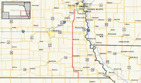 Nebraska Highway 50 highlighted in red | ||||
| Route information | ||||
| Maintained by NDOT | ||||
| Length | 91.45 mi[1] (147.17 km) | |||
| Existed | 1932[2]–present | |||
| Major junctions | ||||
| South end | ||||
| North end | ||||
| Location | ||||
| Counties | Pawnee, Johnson, Otoe, Cass, Sarpy, Douglas | |||
| Highway system | ||||
| ||||

Route description
N-50 begins at the Kansas border south of Du Bois. The highway extends into Kansas as K-63. It runs through farmland, passes through Du Bois, and meets N-8. The two highways overlap, first by going north and then by going west, into Pawnee City. In Pawnee City, the overlap with N-8 ends and a new one with N-65 begins. The two highways overlap going north out of Pawnee City and separate near Table Rock, Nebraska. Two miles north, N-50 briefly overlaps N-4 before going north again. Near Elk Creek, N-50 meets N-62. Further north, N-50 passes through Tecumseh and meets U.S. Highway 136. The highway continues due north from Tecumseh through Syracuse, passing by N-41 and N-128 between Tecumseh and Syracuse. In Syracuse, N-50 meets N-2.[1][3]
N-50 continues due north from Syracuse, meeting US 34 near Avoca. Near Manley, N-50 meets N-1. It continues north and curves northeast before meeting N-66. N-50 and N-66 overlap until the southwestern edge of Louisville, where they separate, though signage on N-50 has "To N-66" signs in the Louisville area, due to a gap in that highway in Louisville. After passing through Louisville, N-50 immediately crosses the Platte River and then immediately meets N-31. N-50 then goes northeast briefly and turns north to go through Springfield, where the highway becomes divided. As the highway approaches Omaha, it meets N-370 and then Interstate 80. It then continues north into the Millard neighborhood of Omaha on 144th Street, then turns northeast onto Millard Avenue. After passing through Millard, N-50 ends by meeting US 275 and N-92.[1][3]
Major intersections
| County | Location | mi[1] | km | Destinations | Notes |
|---|---|---|---|---|---|
| Pawnee | | 0.00 | 0.00 | Continuation into Kansas | |
| | 3.52 | 5.66 | South end of N-8 overlap | ||
| Pawnee City | 12.98 | 20.89 | North end of N-8 overlap, south end of N-65 overlap | ||
| | 16.50 | 26.55 | North end of N-65 overlap | ||
| | 18.57 | 29.89 | South end of N-4 overlap | ||
| | 19.80 | 31.87 | North end of N-4 overlap | ||
| | 20.79 | 33.46 | |||
| Johnson | | 25.81 | 41.54 | ||
| Tecumseh | 32.82 | 52.82 | |||
| | 35.82 | 57.65 | |||
| | 41.83 | 67.32 | |||
| Otoe | | 43.82 | 70.52 | ||
| | 47.81 | 76.94 | |||
| Syracuse | 53.09 | 85.44 | Interchange | ||
| | 56.82 | 91.44 | |||
| Cass | | 62.82 | 101.10 | ||
| | 66.80 | 107.50 | |||
| | 69.82 | 112.36 | |||
| | 70.32 | 113.17 | |||
| Louisville | 74.29 | 119.56 | South end of N-66 overlap | ||
| 75.64 | 121.73 | North end of N-66 overlap | |||
| | 76.51 | 123.13 | |||
| Sarpy | | 77.20 | 124.24 | ||
| Chalco | 86.48 | 139.18 | Interchange | ||
| 87.48 | 140.79 | I-80 exit 440 | |||
| Douglas | Omaha | 91.45 | 147.17 | Northern terminus; continues north as 132nd Street | |
1.000 mi = 1.609 km; 1.000 km = 0.621 mi
| |||||
References
- "Nebraska Highway Reference Log Book" (PDF). Nebraska Department of Roads. 2015. pp. 144–147. Retrieved January 7, 2017.
- "The Nebraska Highways Page: Highways 31 to 60". Archived from the original on 2007-02-08. Retrieved 2007-01-13.
- Google (2010-11-08). "overview of Nebraska Highway 50" (Map). Google Maps. Google. Retrieved 2010-11-08.