Kagera (region)
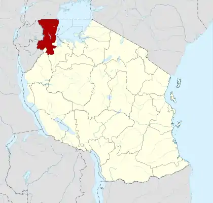
Kagera is one of Tanzania's 31 administrative regions. The region is located in the northwestern corner of Tanzania on the western shore of Lake Victoria. The region neighbours Uganda, Rwanda, and Burundi and lies across the lake from Kenya. The region was known as West Lake before June 1979. The regional capital is the city of Bukoba. According to the 2012 national census, the region had a population of 2,458,023, which was lower than the pre-census projection of 2,763,329.[2]:page 2 For 2002-2012, the region's 3.2 percent average annual population growth rate was tied for the third highest in the country.[2]:page 4 It was also the ninth-most densely populated region, with 97 people per square kilometre.[2]:page 6
Kagera
Mkoa wa Kagera (Swahili) | |
|---|---|
 Karagwe District | |
 Location in Tanzania | |
| Coordinates: 1°55′S 31°18′E | |
| Country | Tanzania |
| Zone | Lake |
| Capital | Bukoba |
| Government | |
| • Regional Commissioner | Brig. Gen. Michael Gaguti |
| Area | |
| • Total | 25,265 km2 (9,755 sq mi) |
| Population (2012) | |
| • Total | 2,458,023 |
| • Density | 97/km2 (250/sq mi) |
| Time zone | UTC+3 (EAT) |
| Postcode | 35xxx |
| Area code(s) | 028 |
| HDI (2018) | 0.501[1] low · 18th of 25 |
| Website | www |
On 10 September 2016, the region was struck by an earthquake measuring 5.9 on the moment magnitude scale. It was the biggest earthquake to have been recorded in Tanzania.[3]
Its attempted annexation by Uganda in 1978 triggered the Uganda–Tanzania War which culminated in the overthrow of Ugandan dictator Idi Amin on 11 April 1979, at the Fall of Kampala.
Location
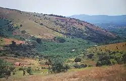
Kagera occupies the northwestern corner of Tanzania. The regional capital is Bukoba, which is about 1,400 kilometres (870 mi) from Dar es Salaam by road. The region shares borders with Uganda to the north, Rwanda and Burundi to the west, the region of Kigoma to the south, and the region of Geita to the east. The region is known for its agriculture, its beautiful lush landscapes, and its wildlife. The Kagera River forms the region's border with Rwanda.
Kagera lies just south of the equator, between 1°00' and 2°45' south latitudes. Longitudinally, it lies between 30°25' and 32°40' east of Greenwich. Out of the region's total area of 40,838 square kilometres (15,768 sq mi), 11,885 square kilometres (4,589 sq mi) is covered by the waters of Lake Victoria, Lake Ikimba, Lake Burigi, and the Ngono and Kagera rivers.[4] The region's total area is just 446 square kilometres (172 sq mi) less than that of Switzerland. Kagera is Tanzania's fifteenth-largest region and accounts for approximately 3.3 percent of Tanzania's total land area of 885,800 square kilometres (342,000 sq mi).[5] It has reasonably fertile old soils, but overuse in some parts of the region has led to soil exhaustion and a need to use fertiliser.
Districts
The region is administratively divided into eight districts:
| Districts of Kagera | ||||||
|---|---|---|---|---|---|---|
| Map | District | Population (2012) |
Area (km²) | |||
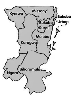 |
Biharamulo District | 323,486 | 5,627 | |||
| Bukoba Rural | 289,697 | |||||
| Bukoba Urban | 128,796 | |||||
| Karagwe District | 332,020 | 7,716 | ||||
| Kyerwa District | 321,026 | |||||
| Missenyi District | 202,632 | 2,709 | ||||
| Muleba District | 540,310 | 10,739 | ||||
| Ngara District | 320,056 | 3,744 | ||||
| Total | 2,458,023 | 40,838 | ||||
Historical background
Kagera was formerly known as the West Lake region. It was renamed Kagera after the Uganda-Tanzania War, when Idi Amin attempted to annexe it in 1978. The region takes its name from the Kagera River, which flows from Rwanda through northern Tanzania before it enters Lake Victoria, to emerge as the Nile, the longest river in the world.
Cultural history
For a period of about five centuries, Kagera was home to nine different kingdoms with highly hierarchical societies. Before European colonialism, coffee was a traditional crop in the area, used for its stimulant properties and in local cultural rituals. During colonial times, coffee was transformed into a cash crop. Bananas were a staple food in the region. Although there was a gender-based division of labour in the traditional Bahaya society, women of the time were not thought to be inferior to men. In fact women commanded special respect in all traditional rituals. For example, upon the death of a head of a family (Nyin'enju), during the following inheritance rituals the "Main Inheritor" (Omusika) had to have a female counterpart selected from among his sisters to share his authority. Similarly, upon the death of a reigning king, during the crowning of the next king, there had to be a "sister to the nation" (Kinyany'engoma) who was also selected from among his sisters.
The kings lived in elaborate palaces and were respected as the direct link to gods of their kingdoms. The authority of the nine kingdoms (Kihanja, Karagwe, Kiziba, Misenye, Bugabo, Kyamtwara, Ihangiro, Bukara and Biharamulo) was diminished when Germans colonised Tanzania in 1885 and supported the Haya, the ethnic group of Bukoba and Muleba Districts over the other districts. However the local kings held on to power. The demise of these kingdoms came after Tanzania gained its independence and president Nyerere considered them detrimental to national unity.
There was a chief called Omukama (the word meant a king or chief) who could be born with that authority. Some prominent chiefs in Kagera include Kyamukuma, who is a last chief in Misenye (currently Missenyi District).[6] Other chiefs include Rumanyika of Karagwe, Ruhinda, Kahigi and other inferior chiefs. Kahigi is among the chiefs who waived their territories by colloborating with German colonialists.
Cultural tours are available for tourists visiting Kagera and can be accessed from the region's capital of Bukoba. These tours include visits to the region's national parks/nature reserves etc.
During German rule Dr. M. Zupitza, then serving as the local medical officer, encountered the plague outbreak in Kiziba (1897–1898). In cooperation with Dr. Robert Koch, he confirmed that the cause was the same bacteria as the outbreak in Bombay.
When authority was transferred to the British who supplanted the Germans, Kagera was open to Lutheran missionary activity. Other Christian denominations including the Roman Catholic church later arrived. Their legacy is seen in the many churches in the region.
Wildlife and national parks
The Kagera region has abundant wildlife, including baboons and other types of monkeys.
Kagera is home to Biharamulo, Burigi, Ibanda and Rumanyika and Orugundu Game reserves, a National Park situated on Rubondo Island and a wildlife sanctuary based on Saa Nane Island. Akagera National Park is located near the region, in Rwanda.
References
- "Sub-national HDI - Area Database - Global Data Lab". hdi.globaldatalab.org. Retrieved 26 February 2020.
- Population Distribution by Administrative Units, United Republic of Tanzania, 2013 Archived 2013-06-12 at the Wayback Machine
- "Sh1.4 billion raised for earthquake survivors". The Citizen. Retrieved 14 September 2016.
- National Sample Census of Agriculture 2002/03: Volume Vr: Regional Report: Kagera Region, Tanzania National Bureau of Statistics, December 2007, page 1
- Field Listing: Area, The World Factbook, United States Central Intelligence Agency
- Seth, Niyikiza [The new Haya Transformation, The legacy of Babumbilo (2014)]