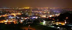
Kajang
Kajang is a town in southeastern Selangor, Malaysia. It is located 20 km southeast of downtown Kuala Lumpur, in the coterminous mukim (commune) of Kajang in the Hulu Langat District.[1]
Kajang | |
|---|---|
Town | |
| Other transcription(s) | |
| • Jawi | كاجڠ |
| • Chinese | 加影 |
| • Tamil | காஜாங் |
 | |
 Flag  Seal | |
| Motto(s): Kajang Bandar Pilihan untuk Didiami (Kajang Choice City for Living) | |
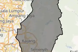
Location in Malaysia | |
 Kajang Location in Malaysia | |
| Coordinates: 2°59′35″N 101°47′20″E | |
| Country | Malaysia |
| State | Selangor |
| Establishment | 1807 |
| Granted municipal status | 1 January 1997 |
| Government | |
| • Yang Di-Pertua (President) | Dato' Haji Rosli bin Othman DPMS |
| Area | |
| • Town | 787.61 km2 (304.10 sq mi) |
| • Urban | 235.71 km2 (91.01 sq mi) |
| Population (2010) | |
| • Town | 342,657 |
| • Density | 435/km2 (167.97/sq mi) |
| • Metro | 539,561 (12th) |
| Time zone | UTC+8 (MST) |
| • Summer (DST) | Not observed |
| Website | http://www.mpkj.gov.my |
Geography and development
Kajang is about half an hour's drive from Kuala Lumpur's central business district, primarily through Jalan Cheras and the Grand Saga Expressway; both routes are part of the national highway 1 system.
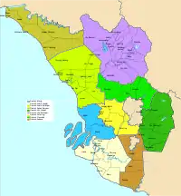
Kajang town is located on the eastern banks of the Langat River. It is surrounded by Cheras, Semenyih, Bangi, Putrajaya and Serdang (clockwise).
In recent years, a few townships were developed in Kajang, such as Taman Prima Saujana, Sungai Chua and Taman Kajang Perdana (Kajang Highlands). High-end developments in Kajang include Twin Palms, Sri Banyan, Country Heights, Jade Hills, TTDI Grove, Tropicana Heights and Prima Paramount.
Areas surrounding these townships are accessible via the SILK Expressway.
Kajang, along with much of Hulu Langat District, is governed by the Kajang Municipal Council.
Etymology
The name of Kajang has multiple possible origins:
The area is believed to have been explored by the Temuan people since 1580. This tribe named Kajang based on an abundant type of screw pine that is used to make roofs.
A member of Ujong River named Batin Berenggai Besi, built huts on the river bank in the area by using a type of screw pine for building the cascading (Kajang) nailed roof. This convinced him that the place is suitable for settlement.
The meaning of the word 'Kajang' in Mendailingese is 'housed/sheltered'. Meanwhile, in Buginese, it is 'battle or quarrel'. These factions once clashed in one of the hilly areas facing the current railway station, because of the misunderstanding of the word 'Kajang'. The incident occurred when both groups fled to the Langat River from the civil war in Klang, between 1867 and 1873. After the incident, the place was named Kajang.
In another source, Kajang was opened by Toh Lili, who came from Riau in 1776. He was the follower of Sultan Mohamed Shah Ibni Al-Marhum Sultan Ibrahim Shah from Riau. With the Sultan's permission, he and six friends opened the land for paddy cultivation at Bukit Sungai Merbau and opened the Merbau River mine, now known as Kajang.
Raja Alang from the Mandailing tribe migrated to Malaya in the early 1800s with a group of followers. The group sailed into Malaya through Kuala Sungai Langat. After days of sailing, they sheltered or 'berkajang' in an area now called Mandailing Road. Some of the followers of Raja Alang explored the area of Kampung Batu 14. Their place was then named by Alang.
History
The first settlement in Kajang came in 1709. In 1807, Kajang was founded after the Klang War. Because of its central location, it was made the district capital of Hulu Langat.
Kajang as a modern town owes its rise in particular to the coffee estates which were opened up around it in the 1890s. One of the famous coffee estates were Inch Kenneth Estate managed by the Kindersley brothers, who were among the first to plant rubber in the country on a commercial basis. Another was Perang Besar (Great War) Estate, opened by some British ex-servicemen led by Colonel Henry Gough, who was the pioneer of bud-grafting of rubber trees in the country.
Kajang was granted municipal status on 1 January 1997. Previously it was under the jurisdiction of the Hulu Langat District Council (Majlis Daerah Hulu Langat, MDHL).
Demographics
Kajang's population of 342,657 is 60.4% Malay, 19.3% Chinese, 9.7% Indians, and 10.6% other ethnic groups.[2]
Kajang's main population centres are Sg. Sikamat, Taman Saujana Impian, Sg. Kantan, Sg. Jelok, Sg. Ramal, Sungai Chua, Jalan Reko, Jalan Bukit, Taman Jenaris, Taman Prima Saujana, Taman Kantan Permai, Taman Kajang Perdana, Taman Sri Ramal, Taman Kajang Prima, Bandar Teknologi Kajang, Hillpark and Bandar Baru Bangi.
Sungai Sikamat area is celebrating its 100 years foundation in 2019.
Landmarks
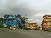
The centre of Kajang is Old Town. Most of the colonial-era buildings were constructed around the 1920s to 1930s. [3] The architecture of these shophouses is a combination of traditional Chinese and European designs. The ground floor was used mostly for commercial activities and the upper floor as the family living quarters.
One of Kajang's landmarks is Kajang Stadium which is situated in the heart of the town. The stadium can accommodate up to 5,000 people and is used throughout the year for the community soccer competitions.
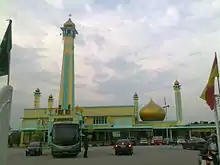
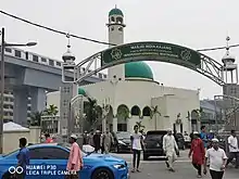
Another landmark is the Kajang Jamek Mosque, which is recognisable by its bright yellow facade.
Transportation
Car
Kajang is served by a network of tolled expressways and federal highways.
Highway 1, the premier north–south federal highway of Peninsular Malaysia, runs through downtown Kajang and then southwards until Johor Bahru. A stretch of highway 1 is concurrent with the Cheras–Kajang Expressway E7 between Cheras Sentral Mall and Taman Koperasi CUEPACS. The Kajang Dispersal Link Expressway E18 starts in Seri Kembangan, which then runs through Balakong and then forms a beltway around downtown Kajang before ending near Bangi. It is the main ring road for Kajang. PLUS Expressway E2 exit 210 serves the vicinity of Kajang and Bangi. From Ampang Jaya, one can reach Kajang with state routes B62 and B52.
Public transport
KB06 SBK35 Kajang railway station is the principal rail station of Kajang. It is an interchange station between the 9 MRT Sungai Buloh-Kajang Line, 1 KTM Seremban Line and ETS KTM ETS. The station is the southern terminal of the MRT line.
Kajang station, though so named, does not directly serve downtown Kajang; Stadium Kajang MRT is located in the actual downtown area, along with Sungai Jernih MRT.
Food and tourism
Kajang is famous for its sate, a form of skewered barbecued meat. Informally, Kajang is known as the Sate Town.[4]
Government and infrastructure
The Malaysia Prison Complex (Kompleks Penjara Kajang), headquarters of the Prison Department of Malaysia is in Kajang.[5][6]
Shopping

Kajang has multiple shopping complexes. The Billion Shopping Center formerly in Kajang town and now it is relocated to Bandar Teknologi Kajang. Other shopping centres located are Metro Plaza Kajang, Metro Point and Kompleks Kota Kajang. Metro Avenue is a new shopping district located opposite SMJK Yu Hua Kajang and Kajang High School.
Facilities and amenities
Public hospitals are free and found within and around Kajang town, including Hospital Kajang, Hospital Serdang and Hospital Putrajaya. Private medical centres function 24 hours and include facilities such as Poliklinik MUC @Metro Point, Klinik Mediviron Prima Saujana, Kajang Plaza Medical Centre (KPMC) and KPJ Kajang Specialist Hospital.
The Hulu Langat District Police Headquarters are located in the town centre. Other services include a post office, government clinics, a stadium, food court and a wet market. Federal government agencies with their branch in Kajang include the National Registration Department, Immigration Department, Transportation Department, and Hulu Langat Education Office
Kajang is the starting point for MRT Sungai Buloh - Kajang with 4 stations within this town. The stations are Stesen Kajang, Stadium Kajang, Sungai Jernih and Simpang Balak.
Education
Primary
- Al-Amin Sungai Tangkas
- Rafflesia International School Kajang 2
- SK Jalan Bukit 1
- SK Jalan Bukit 2
- SK Jalan Semenyih 1
- SK Jalan Semenyih 2
- SK Kajang
- SK Kajang Utama
- SK Kantan Permai
- SK Leftenan Adnan
- SK Saujana Impian
- SK Saujana Impian 2
- SK Seri Sekamat
- SK Taman Jasmin
- SK Taman Sri Jelok
- SRJK(C) Yu Hua
- SRJK(C) Yu Hua 2 (under construction)
- SRJK(C) Sungai Chua
- SRJK(T) Kajang
- Tanarata International Schools
- SK Convent Kajang
- SK Taman Rakan
Secondary
- Rafflesia International School@Kajang 2
- SMK Convent Kajang
- SM Integrasi Tahfiz Ilmuwan Bangi
- SM Rafflesia@Kajang 2
- SM Teknik Kajang
- SMAP Kajang
- SMJK Yu Hua Kajang
- SMK Jalan Bukit
- SMK Jalan Reko
- SMK Kajang Utama
- SMK Saujana Impian
- SMK Sultan Abdul Aziz Shah (SAAS)
- SMK Sungai Ramal (SEMARAK)
- SMK Taman Jasmin 2
- SMK Tinggi Kajang (Kajang High School)
- SMKA Maahad Hamidiah
- Tanarata International Schools

Tertiary
Kajang is home to institutions of higher learning, which includes:
- Universiti Tunku Abdul Rahman (UTAR) Sungai Long Campus
- Universiti Tenaga Nasional
- Infrastructure University Kuala Lumpur
- New Era University College
- German-Malaysian Institute
- Universiti Kuala Lumpur Malaysia France Institute (MFI)
- Universiti Kuala Lumpur Medical Science and Technology (MESTECH)
Politics
After the Malaysian general election, in 2018, Kajang became part of the Bangi parliamentary constituency in the Dewan Rakyat of the Malaysian Parliament. The seat is held by Ong Kian Ming from PH-DAP.
In the Selangor State Legislative Assembly, Kajang is one of three state seats within the Bangi parliamentary district; the other two are Balakong and Sungai Ramal. The incumbent Assemblyperson for Kajang is Hee Loy Sian from PH-PKR.
Until 9 May 2018, Kajang was part of the Hulu Langat parliamentary constituency in the Dewan Rakyat of the Malaysian Parliament.
In the Selangor State Legislative Assembly, Kajang was one of three state seats within the Hulu Langat parliamentary district; the other two were Semenyih and Dusun Tua.
People
- Lt Adnan Bin Saidi, the hero of Battle of Singapore in Bukit Chandu during World War II.
- Ning Baizura, a singer.
- Nora Danish, actress.
- K. Reuben, D. Christie Jayaseelan and Safee Sali, are Malaysian football players.
- K. Sanbagamaran,[7][8][9] a former Selangor FA and Malaysia national football team player.
- Ramli Ibrahim,[10][11][12] Malaysia’s Dance Icon for Indian Classical Dance.
References
| Wikimedia Commons has media related to Kajang. |
- "Wolfram-Alpha: Computational Knowledge Engine". wolframalpha.com. Retrieved 20 November 2016.
- "Population Distribution by Local Authority Areas and Mukims, 2010". Department of Statistics, Malaysia. Archived from the original on 14 November 2014.
- Pradhan, Biswajeet (8 May 2017). Spatial Modeling and Assessment of Urban Form: Analysis of Urban Growth: From Sprawl to Compact Using Geospatial Data. Springer. ISBN 978-3-319-54217-1.
- "Progression of a satay town - Focus - The Star Online". thestar.com.my. Retrieved 20 November 2016.
- "Home." Prison Department of Malaysia. Retrieved on 7 August 2014. "Malaysia Prison Complex, Kajang Selangor." Map.
- "IBU PEJABAT PENJARA MALAYSIA." Prison Department of Malaysia. Retrieved on 7 August 2014. "Bukit Wira, Beg Berkunci No. 212, 43000 Kajang, SELANGOR DARUL EHSAN"
- Strack-Zimmermann, Benjamin. "Sanbagamaran Kalasigaram". www.national-football-teams.com.
- "Will the Era of Greatness Return".
- "4 Pemain Bola Sepak Kaum India Yang Pernah Menghiasi Kancah Bola Sepak Malaysia Di Era 2000 – Mensive". 29 October 2016.
- Devi, Vatsala (13 August 2015). "An Interview with Malaysia's Dance Icon, Datuk Ramli Ibrahim".
- "Archived copy". Archived from the original on 15 April 2018. Retrieved 16 June 2017.CS1 maint: archived copy as title (link)
- ""I am extremely Melayu" | The Nut Graph". www.thenutgraph.com. Retrieved 22 September 2018.
External links
| Wikivoyage has a travel guide for Kajang. |