Kamisato, Saitama
Kamisato (上里町, Kamisato-machi) is a town located in Saitama Prefecture, Japan. As of 1 February 2016, the town had an estimated population of 30,434, and a population density of 1040 persons per km². Its total area is 29.18 square kilometres (11.27 sq mi).
Kamisato
上里町 | |
|---|---|
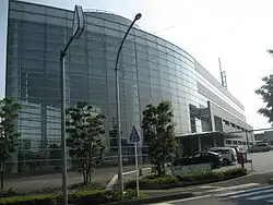 Kamisato town office | |
 Flag  Seal | |
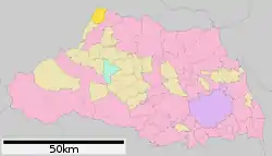 Location of Kamisato in Saitama Prefecture | |
 Kamisato | |
| Coordinates: 36°15′5.9″N 139°8′41.1″E | |
| Country | Japan |
| Region | Kantō |
| Prefecture | Saitama Prefecture |
| District | Kodama |
| Area | |
| • Total | 29.18 km2 (11.27 sq mi) |
| Population (February 2016) | |
| • Total | 30,434 |
| • Density | 1,040/km2 (2,700/sq mi) |
| Time zone | UTC+9 (Japan Standard Time) |
| - Tree | Yaetsubaki |
| - Flower | Salvia splendens |
| Phone number | 0495-35-1221 |
| Address | 982 Shichihongi, Kamisato-machi, Kodama-gun, Saitama-ken 369-0392 |
| Website | http://www.town.kamisato.saitama.jp/ |
Geography
Kamisato is located on the extreme northwestern border of Saitama Prefecture, separated from Gunma Prefecture by the Kanna River, and isolated from the remainder of Saitama by the Chichibu Mountains.
Surrounding municipalities
History
Kamisato village was created on May 3, 1954 by the merger of the villages of Jimbohara, Kami, Shichihongi and Nagahata, all from within Kodama District. Kamisato was elevated to town status on November 3, 1971.
Economy
Kamisato has a large industrial park in the southeastern corner; however, many people commute to neighboring Takasaki or Fujioka.
Education
Kamisato has five elementary schools and two middle schools. There is also an international school, the Instituto Educacional TS Recreação - Brazilian school[1]
Transportation
Railway
Highway
References
- "Escolas Brasileiras Homologadas no Japão" (Archive). Embassy of Brazil in Tokyo. Retrieved on October 13, 2015.
External links
![]() Media related to Kamisato, Saitama at Wikimedia Commons
Media related to Kamisato, Saitama at Wikimedia Commons
- Official Website (in Japanese)
| Saitama |
| |||
|---|---|---|---|---|
| Core cities | ||||
| Special cities |
| |||
| Cities | ||||
| Districts | ||||
| Authority control |
|---|