Misato, Saitama (town)
Misato (美里町, Misato-machi) is a town located in Saitama Prefecture, Japan. As of 1 February 2016, the town had an estimated population of 11,170, and a population density of 334 persons per km². Its total area is 33.41 square kilometres (12.90 sq mi).
Misato
美里町 | |
|---|---|
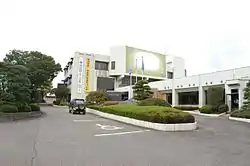 Misato town office | |
 Flag  Seal | |
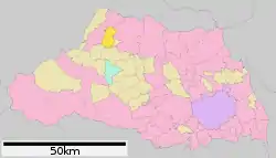 Location of Misato in Saitama Prefecture | |
 Misato | |
| Coordinates: 36°10′37.8″N 139°10′53.2″E | |
| Country | Japan |
| Region | Kantō |
| Prefecture | Saitama Prefecture |
| District | Kodama |
| Area | |
| • Total | 33.41 km2 (12.90 sq mi) |
| Population (February 2016) | |
| • Total | 11,170 |
| • Density | 334/km2 (870/sq mi) |
| Time zone | UTC+9 (Japan Standard Time) |
| - Tree | Japanese Red Pine |
| - Flower | Chrysanthemum |
| Phone number | 0495-76-1111 |
| Address | 323-1 Kibe, Misato-cho, Kodama-gun, Saitama-ken 367-0194 |
| Website | http://www.town.saitama-misato.lg.jp/ |
Geography
Located in western Saitama Prefecture, Misato is on the central reaches of the Arakawa River and is approximately 70 kilometers from downtown Tokyo.
Surrounding municipalities
History
Mastuhisa, Ozawa and Higashikodama villages were created within Naka District, Saitama with the establishment of the municipalities system on April 1, 1889. Naka District was abolished in 1896, becoming part of Kodama District. The three villages merged to form the village of Misato on October 1, 1954. Misato was elevated to town status on October 1. 1984.
Economy
- Eisai has a pharmaceutical plant in Misato, which is a major local employer.
Education
Misato has three elementary schools and one middle school.
Transportation
Railway
External links
![]() Media related to Misato, Saitama (town) at Wikimedia Commons
Media related to Misato, Saitama (town) at Wikimedia Commons
- Official Website (in Japanese)
| Saitama |
| |||
|---|---|---|---|---|
| Core cities | ||||
| Special cities |
| |||
| Cities | ||||
| Districts | ||||
| Authority control |
|---|