Nagatoro, Saitama
Nagatoro (長瀞町, Nagatoro-machi) is a town located in Saitama Prefecture, Japan. As of 1 February 2016, the town had an estimated population of 7,281, and a population density of 244 persons per km². Its total area is 30.43 square kilometres (11.75 sq mi). The Nagatoro River is well known for its rapids and whitewater rafting and boating, and the entire town is designated as a prefectural nature park and preserve.
Nagatoro
長瀞町 | |
|---|---|
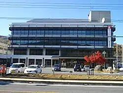 Nagatoro town office | |
 Flag  Seal | |
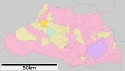 Location of Nagatoro in Saitama Prefecture | |
 Nagatoro | |
| Coordinates: 36°6′53.3″N 139°6′35″E | |
| Country | Japan |
| Region | Kantō |
| Prefecture | Saitama Prefecture |
| District | Chichibu |
| Area | |
| • Total | 30.43 km2 (11.75 sq mi) |
| Population (February 2016) | |
| • Total | 7,281 |
| • Density | 239/km2 (620/sq mi) |
| Time zone | UTC+9 (Japan Standard Time) |
| - Tree | Acer |
| - Flower | Sakura |
| - Bird | Wagtail |
| Phone number | 0494-66-3111 |
| Address | Oji-Honnogami 1035-1, Nagatoro-cho, Chichibu-gun, Saitama-ken 369-1392 |
| Website | http://www.town.nagatoro.saitama.jp/ |

Geography
Located in the mountains of western Saitama Prefecture, Nagatoro is on the upper reaches of the Arakawa River.
Surrounding municipalities
History
The village of Nagami was created within Chichibu District, Saitama with the establishment of the municipalities system on April 1, 1889, and was elevated to town status on February 15, 1940. The town absorbed neighboring Higuchi and part of Shiratori villages on September 8, 1943, and changed its name to Nagatoro on November 1, 1971. In February 1955, the town expanded by annexing the neighboring villages of Orihara, Hachigata, Obusuma, and Yodo.
Economy
The main source of income for Nagatoro is tourism-related industries.
Education
Nagatoro has two elementary schools and one middle school.
Transportation
Railway
Highway
Local attractions
- Nagatoro Gorge
External links
![]() Media related to Nagatoro, Saitama at Wikimedia Commons
Media related to Nagatoro, Saitama at Wikimedia Commons
| Saitama |
| |||
|---|---|---|---|---|
| Core cities | ||||
| Special cities |
| |||
| Cities | ||||
| Districts | ||||
| Authority control |
|---|