Kensington, Whangārei
Kensington is a suburb of Whangārei, in Northland Region, New Zealand. It is about 2 kilometres north of the city centre. State Highway 1 runs through Kensington, The Western Hills form a boundary on the west, and Hātea River on the east.[1]
Kensington | |
|---|---|
Suburb | |
| Country | New Zealand |
| Local authority | Whangarei District Council |
| Population (2018) | |
| • Total | 3,240 |
| Whau Valley | Otangarei | |
|
|
Mairtown | |
| Woodhill | Regent |
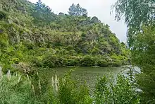
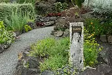
Whangarei Quarry Gardens is a public garden of over 24 hectares set around an artificial lake.[2]
Demographics
| Year | Pop. | ±% p.a. |
|---|---|---|
| 2006 | 3,201 | — |
| 2013 | 3,012 | −0.87% |
| 2018 | 3,240 | +1.47% |
| Source: [3] | ||
Kensington (Whangarei District) had a population of 3,240 at the 2018 New Zealand census, an increase of 228 people (7.6%) since the 2013 census, and an increase of 39 people (1.2%) since the 2006 census. There were 1,389 households. There were 1,527 males and 1,713 females, giving a sex ratio of 0.89 males per female. Of the total population, 480 people (14.8%) were aged up to 15 years, 570 (17.6%) were 15 to 29, 1,443 (44.5%) were 30 to 64, and 747 (23.1%) were 65 or older. Figures may not add up to the total due to rounding.
Ethnicities were 75.3% European/Pākehā, 27.4% Māori, 4.3% Pacific peoples, 8.2% Asian, and 1.5% other ethnicities. People may identify with more than one ethnicity.
The percentage of people born overseas was 19.7, compared with 27.1% nationally.
Although some people objected to giving their religion, 45.1% had no religion, 41.0% were Christian, and 7.2% had other religions.
Of those at least 15 years old, 486 (17.6%) people had a bachelor or higher degree, and 588 (21.3%) people had no formal qualifications. The median income was $25,600. The employment status of those at least 15 was that 1,200 (43.5%) people were employed full-time, 378 (13.7%) were part-time, and 123 (4.5%) were unemployed.[3]
Notes
- Roger Smith, GeographX (2005). The Geographic Atlas of New Zealand. Robbie Burton. map 24. ISBN 1-877333-20-4.
- "Whangarei Quarry Gardens". NZ Gardens Trust. Retrieved 11 May 2020.
- "Statistical area 1 dataset for 2018 Census". Statistics New Zealand. March 2020. Kensington (Whangarei District) (106600). 2018 Census place summary: Kensington (Whangarei District)