Kentucky Route 89
Kentucky Route 89 (KY 89) is a 73.355-mile-long (118.053 km) north–south two-lane state highway that runs from Kentucky Route 490 east of Livingston to Kentucky Route 627 in Winchester in the U.S. state of Kentucky. The highway goes through McKee, Irvine.
| ||||
|---|---|---|---|---|
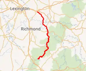
KY 89 highlighted in red | ||||
| Route information | ||||
| Maintained by KYTC | ||||
| Length | 73.355 mi[1] (118.053 km) | |||
| Major junctions | ||||
| South end | ||||
| ||||
| North end | ||||
| Location | ||||
| Counties | Rockcastle, Jackson, Estill, Clark | |||
| Highway system | ||||
| ||||

The route intersects with U.S. Route 421, Kentucky Route 52, Kentucky Route 499, Kentucky Route 974, and U.S. Route 60.
Major intersections
| County | Location | mi[1] | km | Destinations | Notes |
|---|---|---|---|---|---|
| Rockcastle | | 0.000 | 0.000 | Southern terminus | |
| Jackson | | 8.903 | 14.328 | Northern terminus of KY 2002 | |
| | 18.860 | 30.352 | Southern end of US 421 concurrency | ||
| McKee | 19.407 | 31.233 | Northern end of US 421 concurrency | ||
| | 28.520 | 45.898 | Eastern terminus of KY 3446 | ||
| Estill | | 39.721 | 63.925 | Western terminus of KY 1209 | |
| | 46.040 | 74.094 | Northern terminus of KY 851 | ||
| | 46.891 | 75.464 | Southern end of KY 52 concurrency | ||
| | 46.965– 47.115 | 75.583– 75.824 | Bridge over the Kentucky River | ||
| Irvine | 47.160 | 75.897 | Northern end of KY 52 concurrency | ||
| 47.200 | 75.961 | Western terminus of KY 2461 | |||
| | 48.599 | 78.213 | Eastern terminus of KY 499 | ||
| | 48.896 | 78.690 | Southern terminus of KY 1705 | ||
| | 49.231 | 79.230 | Eastern terminus of KY 1840 | ||
| | 52.191 | 83.993 | Northern terminus of KY 794 | ||
| | 53.599 | 86.259 | Southern terminus of KY 82 | ||
| | 55.594 | 89.470 | Eastern terminus of KY 1886 | ||
| Clark | | 61.137 | 98.390 | Eastern terminus of KY 1028 | |
| | 63.031 | 101.439 | Southern end of KY 974 overlap | ||
| | 66.878 | 107.630 | Northern end of KY 974 overlap | ||
| | 72.728 | 117.044 | Southern terminus of KY 1958 | ||
| Winchester | 74.078 | 119.217 | |||
| 74.171 | 119.367 | Northern terminus | |||
| 1.000 mi = 1.609 km; 1.000 km = 0.621 mi | |||||
This article is issued from Wikipedia. The text is licensed under Creative Commons - Attribution - Sharealike. Additional terms may apply for the media files.
