Khao Khitchakut District
Khao Khitchakut (Thai: เขาคิชฌกูฏ, pronounced [kʰǎw kʰít.t͡ɕʰā.kùːt]) is a district (amphoe) in the central part of Chanthaburi Province, eastern Thailand.
Khao Khitchakut
เขาคิชฌกูฏ | |
|---|---|
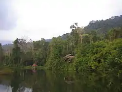 Khao Khitchakut National Park | |
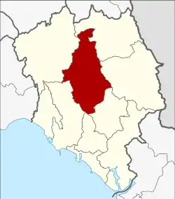 District location in Chanthaburi Province | |
| Coordinates: 12°48′16″N 102°6′53″E | |
| Country | Thailand |
| Province | Chanthaburi |
| Seat | Phluang |
| Area | |
| • Total | 830.2 km2 (320.5 sq mi) |
| Population (2005) | |
| • Total | 25,940 |
| • Density | 31.2/km2 (81/sq mi) |
| Time zone | UTC+7 (ICT) |
| Postal code | 22210 |
| Geocode | 2210 |
History
The area was separated from Makham District and created as a minor district (king amphoe) on 1 July 1993.[1]
On 15 May 2007 it was upgraded to a full district.[2] With publication in the Royal Gazette on 24 August, the upgrade became official. [3]
Geography
Neighboring districts are (from the west clockwise) Kaeng Hang Maeo, Soi Dao, Pong Nam Ron, Makham, Mueang Chanthaburi, and Tha Mai of Chanthaburi Province.
The important water resource is the Chanthaburi River, which originates within Khao Khitchakut National Park.
Administration
The district is divided into five communes (tambons), which are further subdivided into 46 villages (mubans). There are no municipal (thesabans). There are five tambon administrative organizations (TAO).
| No. | Name | Thai name | Villages | Pop. | |
|---|---|---|---|---|---|
| 1. | Chak Thai | ชากไทย | 8 | 4,149 | |
| 2. | Phluang | พลวง | 9 | 6,559 | |
| 3. | Takhian Thong | ตะเคียนทอง | 9 | 4,238 | |
| 4. | Khlong Phlu | คลองพลู | 10 | 5,828 | |
| 5. | Chanthakhlem | จันทเขลม | 10 | 5,166 |
References
- ประกาศกระทรวงมหาดไทย เรื่อง แบ่งเขตท้องที่อำเภอมะขาม จังหวัดจันทบุรี ตั้งเป็นกิ่งอำเภอเขาคิชฌกูฎ (PDF). Royal Gazette (in Thai). 110 (86 ง): 3. 1 Jul 1993.
- แถลงผลการประชุม ครม. ประจำวันที่ 15 พ.ค. 2550 (in Thai). Manager Online.
- พระราชกฤษฎีกาตั้งอำเภอฆ้องชัย...และอำเภอเหล่าเสือโก้ก พ.ศ. ๒๕๕๐ (PDF). Royal Gazette (in Thai). 124 (46 ก): 14–21. 24 Aug 2007.