Mueang Chanthaburi District
Mueang Chanthaburi (Thai: เมืองจันทบุรี, pronounced [mɯ̄aŋ t͡ɕān.tʰáʔ.bū.rīː]) is the capital district (amphoe mueang) of Chanthaburi Province, eastern Thailand.
Mueang Chanthaburi
เมืองจันทบุรี | |
|---|---|
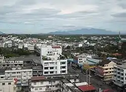 Chanthaburi Town | |
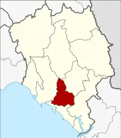 District location in Chanthaburi Province | |
| Coordinates: 12°36′38″N 102°6′15″E | |
| Country | Thailand |
| Province | Chanthaburi |
| Seat | Wat Mai |
| Tambon | 11 |
| Muban | 98 |
| Area | |
| • Total | 253.093 km2 (97.720 sq mi) |
| Population (2013) | |
| • Total | 125,924 |
| • Density | 471.0/km2 (1,220/sq mi) |
| Time zone | UTC+7 (ICT) |
| Postal code | 22000 |
| Geocode | 2201 |
Geography
Neighboring districts are (from the north clockwise) Khao Khitchakut, Makham, Khlung, Laem Sing, and Tha Mai of Chanthaburi Province.
Administration
Central administration
Mueang Chanthaburi is divided into 11 sub-districts (tambons), which are further subdivided into 98 administrative villages (mubans).
| No. | Name | Thai | Villages | Pop.[1] |
|---|---|---|---|---|
| 1. | Talat | ตลาด | - | 9,288 |
| 2. | Wat Mai | วัดใหม่ | - | 15,009 |
| 3. | Khlong Narai | คลองนารายณ์ | 14 | 8,053 |
| 4. | Ko Khwang | เกาะขวาง | 9 | 14,352 |
| 5. | Khom Bang | คมบาง | 10 | 4,305 |
| 6. | Tha Chang | ท่าช้าง | 12 | 28,286 |
| 7. | Chanthanimit | จันทนิมิต | 9 | 13,017 |
| 8. | Bang Kacha | บางกะจะ | 10 | 10,529 |
| 9. | Salaeng | แสลง | 10 | 4,987 |
| 10. | Nong Bua | หนองบัว | 11 | 6,040 |
| 11. | Phlapphla | พลับพลา | 13 | 12,058 |
Local administration
There are three towns (thesaban mueangs) in the district:
- Chanthaburi (Thai: เทศบาลเมืองจันทบุรี) consisting of sub-districts Talat and Wat Mai.
- Chanthanimit (Thai: เทศบาลเมืองจันทนิมิต) consisting of sub-district Chanthanimit.
- Tha Chang (Thai: เทศบาลเมืองท่าช้าง) consisting of parts of sub-district Tha Chang.
There are seven sub-district municipalities (thesaban tambons) in the district:
- Khai Noen Wong (Thai: เทศบาลตำบลค่ายเนินวง) consisting of parts of sub-district Bang Kacha.
- Salaeng (Thai: เทศบาลตำบลแสลง) consisting of sub-district Salaeng.
- Phlapphla (Thai: เทศบาลตำบลพลับพลา) consisting of parts of sub-district Phlapphla.
- Bang Kacha (Thai: เทศบาลตำบลบางกะจะ) consisting of parts of sub-district Bang Kacha.
- Phlapphla Narai (Thai: เทศบาลตำบลพลับพลานารายณ์) consisting of parts of sub-districts Khlong Narai and Phlapphla.
- Nong Bua (Thai: เทศบาลตำบลหนองบัว) consisting of parts of sub-district Nong Bua.
- Ko Khwang (Thai: เทศบาลตำบลเกาะขวาง) consisting of sub-district Ko Khwang.
There are four sub-district administrative organizations (SAO) in the district:
- Khlong Narai (Thai: องค์การบริหารส่วนตำบลคลองนารายณ์) consisting of parts of sub-district Khlong Narai.
- Khom Bang (Thai: องค์การบริหารส่วนตำบลคมบาง) consisting of sub-district Khom Bang.
- Tha Chang (Thai: องค์การบริหารส่วนตำบลท่าช้าง) consisting of parts of sub-district Tha Chang.
- Nong Bua (Thai: องค์การบริหารส่วนตำบลหนองบัว) consisting of parts of sub-district Nong Bua.
References
- "Population statistics 2013" (in Thai). Department of Provincial Administration. Retrieved 2014-11-09.
External links
This article is issued from Wikipedia. The text is licensed under Creative Commons - Attribution - Sharealike. Additional terms may apply for the media files.