Pong Nam Ron District
Pong Nam Ron (Thai: โป่งน้ำร้อน, pronounced [pòːŋ ná(ː)m rɔ́ːn]) is the easternmost district (amphoe) of Chanthaburi Province, eastern Thailand.
Pong Nam Ron
โป่งน้ำร้อน | |
|---|---|
Ban Laem checkpoint | |
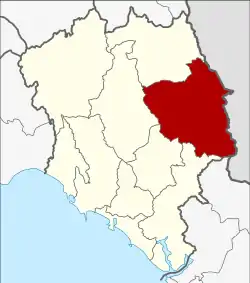 District location in Chanthaburi Province | |
| Coordinates: 12°54′21″N 102°15′46″E | |
| Country | Thailand |
| Province | Chanthaburi |
| Area | |
| • Total | 927.0 km2 (357.9 sq mi) |
| Population (2005) | |
| • Total | 38,115 |
| • Density | 41.1/km2 (106/sq mi) |
| Time zone | UTC+7 (ICT) |
| Postal code | 22140 |
| Geocode | 2204 |
Geography
Neighboring districts are (from the southwest clockwise) Khlung, Makham, Khao Khitchakut and Soi Dao of Chanthaburi Province. To the east are Battambang and Pailin of Cambodia.
Border Crossings
There are two border crossings into Cambodia in Pong Nam Ron.
One is at Ban Pakkard (or Ban Phak Kat) in Klong Yai tambon. The Cambodian town across the border is Phsar Prum in Sala Krau District in Pailin municipality. The second crossing is at Ban Laem in Thep Nimitr. The Cambodian village across the border is Daun Lem in Kamrieng District, Battambang Province.
History
The minor district (king amphoe) Pong Nam Ron was upgraded to a full district on 25 July 1941.[1]
Administration
The district is divided into five sub-districts (tambons), which are further subdivided into 47 villages (mubans). Pong Nam Ron is a township (thesaban tambon) which covers parts of tambons Pong Nam Ron and Thap Sai. There are a further five tambon administrative organizations (TAO).
| No. | Name | Thai name | Villages | Pop. | |
|---|---|---|---|---|---|
| 1. | Thap Sai | ทับไทร | 9 | 11,505 | |
| 2. | Pong Nam Ron | โป่งน้ำร้อน | 13 | 8,878 | |
| 4. | Nong Ta Khong | หนองตาคง | 10 | 8,707 | |
| 9. | Thep Nimit | เทพนิมิต | 8 | 4,743 | |
| 10. | Khlong Yai | คลองใหญ่ | 7 | 4,282 |
Missing numbers are tambon which now form Soi Dao District.
References
- ประกาศสำนักนายกรัฐมนตรี เรื่อง ตั้งอำเภอ (PDF). Royal Gazette (in Thai). 58 (0 ง): 2291–2293. July 25, 1941.
