Khao Sam Roi Yot National Park
Khao Sam Roi Yot (Thai: เขาสามร้อยยอด) is a marine national park in Kui Buri District, Prachuap Khiri Khan Province, Thailand.[2] It covers 98.08 km2 (37.87 sq mi; 61,300 rai),[3] of which 20.88 km2 (8.06 sq mi; 13,050 rai) are marine areas. The park was established in 1966, and was the first coastal national park of Thailand. The park includes Thailand's largest freshwater marsh.[4]
| Khao Sam Roi Yot National Park | |
|---|---|
IUCN category II (national park) | |
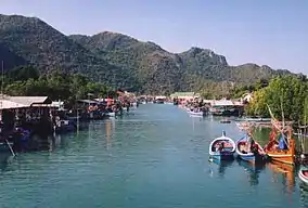 Harbor, Bang Pu | |
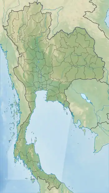 Map of Thailand | |
| Location | Prachuap Khiri Khan Province, Thailand |
| Nearest city | Pranburi |
| Coordinates | 12°10′57″N 99°56′54″E |
| Area | 98.08 km2 (37.87 sq mi) |
| Established | 1966 |
| Official name | Khao Sam Roi Yot Wetland |
| Designated | 8 January 2008 |
| Reference no. | 2238[1] |
Geography
The limestone hills are a sub-range of the Tenasserim Hills that arise at the shore of the Gulf of Thailand, with the highest elevation being Khao Krachom at 605 meters (1,985 ft). Between the hills are freshwater marshes. Several of these marshes were converted into shrimp farms, as only 35 km2 (14 sq mi; 22,000 rai) of the total 69 km2 (27 sq mi; 43,000 rai) of marshes are part of the national park. A portion, 18 km2 (6.9 sq mi; 11,000 rai), of these marshes are scheduled to be declared a Ramsar site.
Two white sand beaches are in the park, Hat Laem Sala and Hat Sam Phraya. Hat Laem Sala is 17 km from park headquarters and can be reached from the village Ban Pu either by boat or by climbing up and down over a hill for nearly 30 minutes.
The park is approximately 58 kilometers (36 mi) south of Hua Hin.
The origin of the name "Khao Sam Roi Yot" is undetermined. Local lore has it that it means "mountain with 300 peaks,"[2][5] or the range had been an island where 300 survivors from a sinking Chinese junk sought refuge, or the range was named after a local plant called sam roi yot.[3]
Phraya Nakhon Cave
Phraya Nakhon Cave (ถ้ำพระยานคร) is about 500 meters (1,600 ft) from Laem Sala Beach, approximately 17 kilometers (11 mi) north of park headquarters. Visitors can go to the cave by renting a boat or by walking across Tian Mountain. After that, there is a climb up the mountain about 430 meters (1,410 ft) to reach Phraya Nakhon Cave. Its most famous early visitor was King Chulalongkorn.[3]
There is a water well at the foot of the mountain known as Phraya Nakhon Well. It is made of baked clay bricks in a trapezoidal shape.
Phraya Nakhon is a large cave which has a hole in the ceiling allowing sunlight to penetrate. At the top of the hole, there is a stone bridge known as "death bridge" because many wild animals have fallen to their deaths from it.
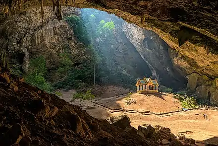
Khuha Kharuehat Pavilion (พระที่นั่งคูหาคฤหาสน์) is a historic site built for King Chulalongkorn's visit in 1890. At certain times during certain months, the sun will shine directly on it. The pavilion has since become the symbol of Prachuap Khiri Khan Province. Later kings also visited the cave, including King Vajiravudh and King Bhumibol Adulyadej.
Klong Khao Daeng
Klong Khao Daeng is a 4-kilometer-long (2.5 mi) stream running deep into mangrove forests at one end and at its mouth freshwater and seawater collide. The mangroves consist of the samae thalay (grey mangrove), kongkang bai lek (true mangrove), kongkang bai yai (red mangrove), and chakhram (herbaceous seepweed).[3]
Climate
The temperature in winter (between October - February) ranges from 18˚C to 25˚C.
The temperature in summer (between March - May) ranges from 23˚C to 32˚C.
The temperature in the monsoon season (between June - September) ranges from 20˚C to 30˚C.
Fauna
The park is home to a variety of birds, including the common kingfisher, the black-capped kingfisher, the collared kingfisher, the little heron, the little egret, and the Javan pond-heron. Wildlife found in the mangroves includes pla teen ([mudskippers]), pu kam dab (fiddler crabs), ling samae (the crab-eating macaque), collared kingfisher (nok kin pieo), snapping shrimp (kung deed khan), mud creeper (hoi khika), and oysters (hoi nangrom).[3] Rare animals in the park include the mainland serow (Nemorhaedus sumatraensis), dusky langurs (Trachypithecus obscurus), fishing cats (Prionailurus viverrinus) (Thai: เสือปลา; RTGS: suea pla),[4] as well as many bird species. At sea, Irrawaddy dolphins (Orcaella brevirostris) are sometimes seen.[6]
History
Khao Sam Roi Yot was probably where King Mongkut hosted European guests on 18 August 1868 to observe a total solar eclipse. The king was interested in astronomy and had calculated the date and location of the eclipse himself. His calculations proved better—by about two seconds—than those of French astronomers, who acknowledged his accuracy. He contracted malaria, possibly during that event, and died on 1 October.
The national park was created on 28 June 1966.[7] It was enlarged on 1 April 1982.[8]
Archaeology
The discovery of 3,000 years old cave paintings was announced by archaeologists from the Fine Arts Office in May in 2020. Some of the depicted pictures are still visible and clear, while some paintings were damaged by limestone etching. According to archeologist Kannika Premjai, paintings describe humanlike figures with accessories on their bodies, hunting scenes with bow and arrow. Moreover, there is also an animal figure seems to be serow (a goat-like mammal found regionally) found among the drawings.[9] In October 2020, more rock art was discovered in unmapped caves in Sam Roi Yot National Park, dates back to between 2,000 and 3,000 years old.[10]
Khao Sam Roi Yot legends
According to Thai folklore, the giant Mong Li and his wife lived on the west coast of the Gulf of Thailand. Each had independently promised their daughter to Chao Lai and the emperor of China. When the daughter was old enough to marry, both future husbands arrived on the same date. Mong Li then cut his daughter into two halves. Chao Lai turned himself into a hill, while the traditional fruit basket to be presented to a Buddhist monk was turned into the Khao Sam Roi Yot mountains.
Islands
The island of Ko Kho Ram on the other side of the gulf was the elephant and the ox cart with the wedding presents.[11] Nom Sao Island is the daughter's breasts. Ao Sam Roi Yot, Kho Ram Island and Nom Sao Island's silhouette, seen from certain angles, look like a person resting in the middle of the sea. There is a goddess shrine on Nom Sao Island that is a popular attraction.[12]
Other islands in the same area are Ko Sattakut, Ko Rawang, and Ko Rawing.
See also
References
- "Khao Sam Roi Yot Wetland". Ramsar Sites Information Service. Retrieved 25 April 2018.
- "Khao Sam Roi Yot National Park". Department of National Parks (DNP) Thailand. Archived from the original on 15 October 2015. Retrieved 14 August 2015.
- Svasti, Pichaya (21 June 2018). "Close to Nature". Bangkok Post. Retrieved 21 June 2018.
- Jewett, Katie (6 December 2016). "Fishing-Cat's Cradle". Bangkok Post. Retrieved 6 December 2016.
- "Khao Sam Roi Yot National Park". Tourism Authority of Thailand (TAT). Archived from the original on 6 November 2016. Retrieved 6 November 2016.
- Elliot, Stephan; Cubitt, Gerald (2001). THE NATIONAL PARKS and other Wild Places of THAILAND. New Holland Publishers (UK) Ltd. pp. 48–53. ISBN 9781859748862.
- พระราชกฤษฎีกากำหนดบริเวณที่ดินป่าเขาสามร้อยยอด ในท้องที่ตำบลสามร้อยยอด ตำบลศิลาลอย อำเภอปราณบุรี และตำบลสามกระทาย ตำบลดอนยายหนู ตำบลเขาแดง อำเภอกุยบุรี จังหวัดประจวบคีรีขันธ์ ให้เป็นอุทยานแห่งชาติ พ.ศ. ๒๕๐๙ (PDF). Royal Gazette (in Thai). 83 (53 ก): 420–423. 28 June 1966.
- พระราชกฤษฎีกาขยายเขตอุทยานแห่งชาติป่าเขาสามร้อยยอด ในท้องที่ตำบลสามร้อยยอด ตำบลศิลาลอย ตำบลไร่เก่า อำเภอปราณบุรี และตำบลสามกระทาย ตำบลดอนยายหนู ตำบลเขาแดง อำเภอกุยบุรี จังหวัดประจวบคีรีขันธ์ พ.ศ. ๒๕๒๕ (PDF). Royal Gazette (in Thai). 99 (46 ก special): 5–8. 1 April 1982.
- "Ancient cave paintings discovered in western Thailand". www.msn.com. Retrieved 2020-05-31.
- "Cave raiders: Thai archaeologists hunt ancient artwork". phys.org. 6 October 2020.
- Ko Kho Ram - Mapcarta
- Khao Sam Roi Yot National Park - Activities Archived March 17, 2010, at the Wayback Machine
Further reading
- Denis Gray, Collin Piprell, Mark Graham: National Parks of Thailand. Communications Resources Ltd., Bangkok 1991, ISBN 974-88670-9-9
External links
| Wikimedia Commons has media related to Khao Sam Roi Yot National Park. |
- ASEAN Regional Centre for Biodiversity Conservation
- Bangkok Post article in the land use controversies
- thaibirding.com on Khao Sam Roi Yot National Park
- Travel to Phraya Nakhon Cave (Thai)
- Phraya Nakhon Cave – Prachuaptown (Thai)
- The park King Chulalongkorn visited (Thai)
| Authority control |
|---|