Khao Kho National Park
The Khao Kho National park (Thai: อุทยานแห่งชาดิเขาค้อ;RTGS: Utthayan Haeng Chat Khao Kho) is located in Lom Kao, Lom Sak, Khao Kho and Mueang Phetchabun districts in Phetchabun province.
| Khao Kho National Park | |
|---|---|
| อุทยานแห่งชาติเขาค้อ | |
IUCN category II (national park) | |
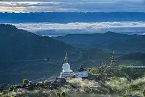 In the foreground Wat Phra That Pha Son Kaeo | |
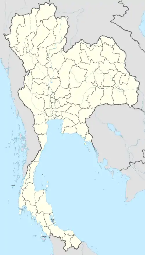 Location with in Thailand | |
| Location | Phetchabun |
| Coordinates | 16°40′00″N 100°58′00″E |
| Area | 483.72 km2 (186.77 sq mi) |
| Established | 2012 |
| Visitors | 106,017 (in 2015) |
| Governing body | Department of National Parks, Wildlife and Plant Conservation |
Topography
Landscape is mostly covered by mountains and forests, the height ranged from 155 metres (509 ft) to 1,305 metres (4,281 ft), Khao Kha the highest point in the park. The national park is named after Khao Kho, a mesa high 1,143 metres (3,750 ft). This part of the Phetchabun mountain range is the origin of the main tributaries of the Pa Sak, Yom and Nan rivers.[1]
Climate
Weather measurement station at the Khao Kho National park collects data of temperature, relative humidity and rainfall since June 1999. The park is generally cool all year round, with rainy season around mid-May to October. Rainfall is approximately 1,425 millimetres (56.1 in)/year, with rainfall for 126 days a year. Winter is around November to mid-February. Summer is around mid-February to mid-May.[2]
History
From 1968 to 1981 the park's forest was used as a base for guerrillas of the Communist Party of Thailand. On 1 May 1995 an area of 14 km2 (5.4 sq mi) in the Khao Polok Lon National Forest, originally named Namtok Than Thip Forest Park, was declared as Khao Kho National Park. A survey was set up of Khok Sam Sang forest, Khao Polok Lon forest, Khao Pang Kho forest and Wang Chompu forest in the area of Lom Kao district, Lom Sak district, Khao Kho district and Mueang Phetchabun district of Phetchabun province on 16 August 2001. Later on 18 May 2012 Khao Kho National Park, with an area of 482.72 km2 (186.38 sq mi) has been declared the 125th national park.[2][3]
Fauna
There are more than 100 species of birds and there is also a wide variety of butterflies.
Places
- Namtok Tat Fa - largest waterfall in Khao Kho national park.
- Namtok Than Thip - 26 m (85 ft) high waterfall.
- Namtok Huai Yai - 20 m (66 ft) high waterfall.
- Namtok Khan Bandai - a 20-tiered waterfall.
- Namtok Wang Nam Rin - 5 m (16 ft) high waterfall.
- Namtok Pha Lat - a waterfall off a cliff.
- Namtok Kaeng Liang Pha - waterfall with a large stone yard.
- Tham Yai Nam Ko - a cave.
- Khao Kho royal palace - temporarily residence from late King Bhumidol Adulyadaj (1985).
- Wat Phra That Pha Son Kaeo - temple with five large sitting Buddha images in line (2004).
- Khao Kho wind farm - wind farm with 24 wind turbines each 110 m (360 ft) tall.[1][4]
References
| Wikimedia Commons has media related to Khao Kho National Park. |
- National Parks in Thailand: Khao Kho National Park (PDF). Department of National Parks (Thailand). 2015. p. 35. ISBN 978-616-316-240-3. Retrieved 14 January 2021.
- "Khao Kho national park". Department of National Parks, Wildlife and Plant Conservation. 2020. Retrieved 14 January 2021.
- "พระราชกฤฐีกา กำหนดบริเวณที่ดินป่าโคกซำซาง ป่าเขาโปลกหล่น ป่าเขาปางก่อ และป่าวังชมภู ในท้องที่ตำบลนาซำ ตำบลหินฮาว ตำบลวังบาล คำบลบ้านเนิน อำเภอหล่มเก่า ตำบลน้ำก้อ ตำบลน้ำชุน ตำบลบุ่งน้ำเต้า ตำบลบุ่คล้า อำเภอหล่มสัก ตำบลแคมป็สน ตำบลทุ่งสมอ ตำบลเขาค้อ ตำบลริมสีม่วง ตำบลสะเดาะพง ตำบลหนองแม่นา อำเภอเขาค้อ และตำบลท่าพล ตำบลป่าเลา อำเภอเมืองเพชรบูรณ์ จังหวัดเพชรบูรณ์ ให้เป็นอุทยานแห่งชาติ พ.ศ.๒๕๕๕" [Royal Decree: Determine Khok Sam Sang forest, Khao Polok Lon forest, Khao Pang Kho forest and Wang Chomphu forest in the area of Na Sam Subdistrict, Hin Hao Subdistrict, Wang Ban Subdistrict, Ban Noen Subdistrict, Lom Kao District, Nam Ko Subdistrict, Nam Chun Subdistrict, Bung Namtao Subdistrict, Bung Khla Subdistrict, Lom Sak District, Khaem Son Subdistrict, Thung Samo Subdistrict, Khao Kho Subdistrict, Rim Si Muang Subdistrict, Sado Pong Subdistrict, Nong Mae Na Subdistrict, Khao Kho District and Tha Phon Subdistrict, Pa Lao Subdistrict, Mueang Phetchabun District, Phetchabun Province to be a national park. B.E.2555 (2012)] (PDF). Royal Thai Government Gazette. 129 (43 Kor): 1–3. 18 May 2012. Retrieved 15 January 2021.
- "Khao Kho National Park". Department of National Parks, Wildlife and Plant Conservation. 2020. Retrieved 15 January 2021.