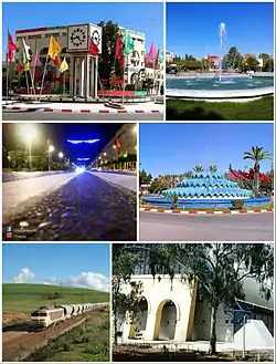
Khouribga
Khouribga (Berber languages: ⵅⵯⵔⵉⴱⴳⴰ, Arabic: خريبكة) is the capital of Khouribga Province in the Béni Mellal-Khénifra region of Morocco. With a population of 196,196 (2014 census),[1] Khouribga owes its growth to the phosphate deposits nearby.
Khouribga
خريبكة / ⵅⵯⵔⵉⴱⴳⴰ | |
|---|---|
 | |
| Nickname(s): Phosphate City | |
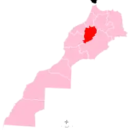
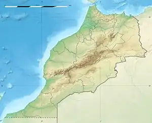 Khouribga Location in Morocco  Khouribga Khouribga (Africa) | |
| Coordinates: 32°53′N 6°55′W | |
| Country | |
| Region | Béni Mellal-Khénifra |
| Province | Khouribga |
| Government | |
| • Mayor | Cherki Al Gholmi (Justice and Development Party) (2015) |
| • Governor | Hamid Chnouri (2018) |
| Area | |
| • Total | 52 km2 (20 sq mi) |
| Elevation | 786 m (2,579 ft) |
| Population (2014)[1] | |
| • Total | 196,196 |
| • Density | 4,083.46/km2 (10,576.1/sq mi) |
| • Rank | 15th in Morocco |
| Time zone | UTC+1 (CET) |
| Postal Code | 25000 |
Geography
Located at least 120 km from Casablanca, 154 km from the capital, Rabat, 200 km from the city of Marrakesh, 99 km from the city of Beni Mellal and 60 km from the city of Settat.
Khouribga is located 820 meters above sea level on the Ouardigha plateau. The city was founded in 1923 by the authorities of the French protectorate when they discovered phosphate in the region, for which Morocco is considered to be the biggest exporter in the world. There are several mines in the province, most notably the mine of Sidi Shennan near the town of Oued Zem, which lies 30 km from the village of Boulanouar (5 km) and the town of Boujniba (10 km) and the village of Hattane.
The Province of Khouribga is bordered by the Province of Beni Mellal in the east, Province of Ben Slimane in the west, the Province of Settat in the south, and Khémisset Province in the north.
Climate
Khouribga has a hot-summer Mediterranean climate (Köppen climate classification Csa). In winter there is more rainfall than in summer. The average annual temperature in Khouribga is 17.2 °C (63.0 °F). About 432 mm (17.01 in) of precipitation falls annually.
| Climate data for Khouribga | |||||||||||||
|---|---|---|---|---|---|---|---|---|---|---|---|---|---|
| Month | Jan | Feb | Mar | Apr | May | Jun | Jul | Aug | Sep | Oct | Nov | Dec | Year |
| Average high °C (°F) | 16.7 (62.1) |
17.6 (63.7) |
19.8 (67.6) |
22.6 (72.7) |
26.1 (79.0) |
30.6 (87.1) |
36.0 (96.8) |
36.2 (97.2) |
32.5 (90.5) |
27.0 (80.6) |
19.3 (66.7) |
17.1 (62.8) |
25.1 (77.2) |
| Daily mean °C (°F) | 9.9 (49.8) |
10.4 (50.7) |
12.4 (54.3) |
14.6 (58.3) |
17.8 (64.0) |
21.9 (71.4) |
26.1 (79.0) |
26.7 (80.1) |
23.8 (74.8) |
19.2 (66.6) |
12.7 (54.9) |
10.6 (51.1) |
17.2 (62.9) |
| Average low °C (°F) | 3.2 (37.8) |
3.3 (37.9) |
5.0 (41.0) |
6.6 (43.9) |
9.5 (49.1) |
13.2 (55.8) |
16.3 (61.3) |
17.2 (63.0) |
15.1 (59.2) |
11.4 (52.5) |
6.1 (43.0) |
4.1 (39.4) |
9.2 (48.7) |
| Average precipitation mm (inches) | 60 (2.4) |
58 (2.3) |
57 (2.2) |
52 (2.0) |
22 (0.9) |
7 (0.3) |
2 (0.1) |
3 (0.1) |
12 (0.5) |
36 (1.4) |
52 (2.0) |
71 (2.8) |
432 (17) |
| Source: https://en.climate-data.org/location/715066/ | |||||||||||||
Economy
Phosphate
The Province of Khouribga has a large phosphate reserve estimated 35 to 40 billion cubic meters, which is ranked first at the international level. Also Khouribga is one of the cities that brings hard currency and that is due to its community residents from Italy.
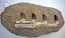
The phosphate mines are notable source of fossils, especially Mosasaur jaws and teeth. The bones and teeth of fossil animals are the source of the mineable phosphate minerals, here and elsewhere.
Industrial activities
In addition to phosphate mining, the province knew the emergence of other industries in economic sectors such as:
Industrial areas
The province has three Industrial zones:
Services
The province has several services, among them:
- 25 bank agencies
- 6 insurance agencies
- 7 travel agencies
- 2 railways with daily trips with a project to build a modern station.
Agriculture
The agricultural lands is divided into 50% arable land, 20% forests, 30% unused land. Livestock is the most important source of income for the rural population, the herd is estimated to be:
Handicrafts
The handicrafts sector represents a sizable part of the local economy with 9 cooperatives (260 members), and a handicrafts association.
Health
The facilities cover most of the province with:
- 6 rooms
- 3 provincial hospitals
- 20 health centers
- 7 urban health centers
- 9 rural clinics
Notable people
- Hindi Zahra, International singer.
- Hind Dehiba, née Chahyd on March 17, 1979 in Khouribga, a Moroccan-French middle-distance runner.
- Jawad El Yamiq professional footballer .
- Otmane El Assas, former professional footballer
References
- "POPULATION LÉGALE DES RÉGIONS, PROVINCES, PRÉFECTURES, MUNICIPALITÉS, ARRONDISSEMENTS ET COMMUNES DU ROYAUME D'APRÈS LES RÉSULTATS DU RGPH 2014" (in Arabic and French). High Commission for Planning, Morocco. 8 April 2015. Retrieved 29 September 2017.