Knebworth
Knebworth is a village and civil parish in the north of Hertfordshire, England, immediately south of Stevenage. The civil parish covers an area between the villages of Datchworth, Woolmer Green, Codicote, Kimpton, Whitwell, St Paul's Walden and Langley, and encompasses the village of Knebworth, the small village of Old Knebworth and Knebworth House.
| Knebworth | |
|---|---|
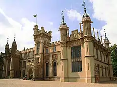 Knebworth House, Knebworth | |
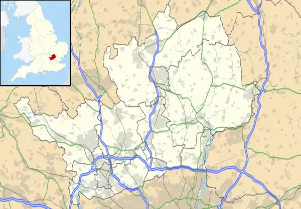 Knebworth Location within Hertfordshire | |
| Population | 4,496 (2011 Census)[1] |
| OS grid reference | TL252201 |
| District | |
| Shire county | |
| Region | |
| Country | England |
| Sovereign state | United Kingdom |
| Post town | KNEBWORTH |
| Postcode district | SG3 |
| Dialling code | 01438 |
| Police | Hertfordshire |
| Fire | Hertfordshire |
| Ambulance | East of England |
| UK Parliament | |
History
There is evidence of people living in the area as far back as the 11th century as it is mentioned in the Domesday Book of 1086 where it is referred to as Chenepeworde (the farm belonging to the Dane, Cnebba),[2] with a recorded population of 33 households and land belonging to Eskil (of Ware),[3] a thegn of King Edward the Confessor.
The original village, now known as Old Knebworth, developed within the parish of the Church of St Mary and St Thomas. The stone church was built around 1120,[4] and although the Domesday Book makes no mention of the church there is speculation to suggest there may have been a Saxon church of timber on the site before the more substantial one was built.[5]
The manor passed into the hands of the Lytton family around 1492, when the manor house was rebuilt to a Late Gothic manor house. The house changed very little until the 19th century when it was re-modelled into the present-day Tudor Gothic building.
Knebworth was a largely agricultural community, producing wheat and barely in particular.[6] The proximity to London via the Great North Road (subsequently the A1, and now the B197 since the opening of the A1(M) motorway in 1962) made it possible to transport produce.[3]
By the start of the 19th century Knebworth had a population of around 250 people but the industrial revolution and the railway coming to Knebworth changed that. Development of the newer Knebworth village started was centred a mile to the east of Old Knebworth on the new railway station and the Great North Road.[5] The railway which was originally meant to go through Codicote to the West was negotiated by Lord Lytton to go through the grounds of Knebworth and that a station be built. The Great Northern Railway, itself opened in 1850, opened a station at Knebworth in 1884.[5] The Station created a brand-new settlement called Knebworth Station known later as New Knebworth, then, just as Knebworth, with the original village becoming known as Old Knebworth.[5] Lord Lytton set up a company, Knebworth Garden Villages, to build homes either side of the railway embankment.[5] Prior to this only a few farmhouses had stood nearby including Swangley’s farm and Deards End farm.[7] The Station eventually grew to include a signal box and goods yard to the north, approximately where Kerr Close is now.
Migrants from London, neighbouring counties and even more distant areas of the country came to work in the new settlement.[5]
At the turn of the century the architect Edwin Lutyens built Homewood, southeast of Old Knebworth, as a dower house for Edith Bulwer-Lytton.[8] Her daughter, the suffragette Constance Lytton also lived there, until just before her death in 1923.[9] Ediths third daughter Lady Emily Bulwer-Lytton had married Lutyens in 1897.[10] Lutyens was responsible for a number of notable buildings in the new village of Knebworth as well, including the Bank, St Martins church, the Golf Clubhouse and the telephone exchange.
Knebworth has, since 1974, been famously associated with numerous major open air rock and pop concerts at Knebworth House. These include Knebworth Fair in 1976, featuring Lynyrd Skynyrd, as well as Queen's final live performance which took place on 9 August 1986 and drew an attendance estimated at 125,000.
In 1996, Oasis played to a quarter of a million people over two nights, for which 2.5 million people (4% of the British population) applied for tickets, a figure that could have led to 20 sold out nights and remains the highest demand for a British concert to date. Most recently, for three nights in August 2003 Robbie Williams performed to the largest crowds ever assembled for a single performer.
Twinning
On 16 June 1990 the village was twinned with the commune of Châtelaillon-Plage in France.[11] In their own words; the Knebworth twining Organisation exists to "encourage friendships between schools, sports clubs and social groups in the two towns".[12] The group organises social events throughout the year.[12]
Knebworth is twinned with:
 Châtelaillon-Plage, France[13]
Facilities
- Knebworth Post Office
- Doctors Surgery
- Knebworth Village Hall
Education and leisure
- Knebworth Primary and Nursery school, Swangleys Lane
- Raja Tandoori, restaurant and takeaway, London Road
- The Roebuck Inn, its oldest public house (now in Stevenage), which dates back to 1420
- The Lytton Arms (public house in Old Knebworth), an early Victorian building
- The Station, a public house, built in 1883
- Recreation ground, incorporating football pitches, tennis courts, bowling green and children's play equipment
Places of worship
- St Martin's, Church of England, designed by Sir Edwin Lutyens and consecrated by the bishop of St Albans, Edgar Jacob, in 1915
- St Mary's, Church of England, parts of which date back to 1120
- St Thomas More, Roman Catholic Church, built in 1962 having replaced a temporary church that had existed since 1935.[14]
- Trinity Church, a Methodist Church and United Reformed Church local ecumenical partnership built in 1996 with roots in the village dating back to 1880
Sport and leisure
Knebworth has a Non-League football club Knebworth F.C. who play at Knebworth Recreation Ground. Knebworth Tennis Club and Knebworth Bowls Club are also based at the Recreation Ground.
Knebworth Park Cricket Club play at their ground in Knebworth Park. Green Dragon Bowmen, an archery club, are also based in the Park.
Nature reserve
Transport
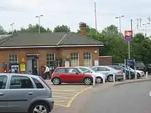
Knebworth has a railway station, which has four platforms, running on the East Coast Main Line. Southbound services run towards London King's Cross while northbound services run towards Cambridge and Peterborough. The station and its train services are operated by Great Northern.
Statistics
Statistics from UK Census 2011:[15]
- All Residents: 5,247
- Number of households: 2,203
- Average household size: 2.30
- Residents in households: 5,136
- Residents in communal living: 111
- Area (hectares): 1,958
- Population density (people per hectare): 2.70
The developed part of Knebworth around the railway station is approximately 120 ha. This gives a density of approximately 17 dwellings per hectare.[16] Recent developments such as New Close, Kerr Close, Peter's Way and Woodstock and (the extension of) Wadnall Way have significantly increased this average density. The population of Knebworth has approximately doubled since 1970.[17]
Notable inhabitants
- A. Duncan Carse, painter, of Deards End 1922-1923[18]
- Barbara Follett
- David Lytton-Cobbold, 2nd Baron Cobbold
- Earls of Lytton
- Edward Bulwer-Lytton
- Henry Lytton-Cobbold
- James Oswald (1710-1769), 18th Century composer
- Ken Follett
- Robert Wilson, MBE, founder of Music for Youth
- Tony Byworth, notable country music journalist
- Tony Cascarino, retired Irish football player
Local publications
The Knebworth Parish News is published monthly and delivered to around 800 homes in Knebworth. It is published on paper only. Although it contains secular articles, the cost of production is underwritten by the Parochial Church Council, which has editorial control of the publication.
The Stevenage Comet is delivered to a small number of homes in the village.
See also
References
- "Civil Parish population 2011". Neighbourhood Statistics. Office for National Statistics. Retrieved 30 October 2016.
- "Knebworth - A Discussion of Changes During the Last Twenty Years of the Nineteenth Century" (PDF). Retrieved 16 August 2020.
- "Knebworth | Domesday Book". opendomesday.org. Retrieved 16 August 2020.
- "Parishes: Knebworth | British History Online". www.british-history.ac.uk. Retrieved 16 August 2020.
- Hudson, Ian. "The development of Knebworth". Herts Memories. Retrieved 16 August 2020.
- "Knebworth farms". Herts Memories. Retrieved 16 August 2020.
- "Knebworth farms". Herts Memories. Retrieved 16 August 2020.
- Historic England. "Homewood (1000911)". National Heritage List for England. Retrieved 1 December 2015.
- Jenkins, Lyndsey (2015). Lady Constance Lytton: Aristocrat, Suffragette, Martyr. London: Biteback Publishing. pp. 228–30. ISBN 978-1-84954-795-6.
- Lutyens, Mary (1980). Edwin Lutyens by his daughter. London: J. Murray. ISBN 978-0-7195-3777-6. OCLC 469680629.
- "Knebworth Twinning Association". Knebworth Twinning Association. Retrieved 16 August 2020.
- "About Us". Knebworth Twinning Association. 9 January 2017. Retrieved 16 August 2020.
- "British towns twinned with French towns". Archant Community Media Ltd. Archived from the original on 5 July 2013. Retrieved 11 July 2013.
- https://parish.rcdow.org.uk/knebworth/about-the-parish/
- UK Census Data for Knebworth
- Google Maps area tool.
- Private communication
- Royal Academy Dictionary of Exhibitors: Summer Exhibition catalogue archives