Aldenham
Aldenham is a village and civil parish in Hertfordshire, 3.5 miles (5.6 km) north-east of Watford and 2 miles (3.2 km) southwest of Radlett. It was mentioned in the Domesday Book and is one of Hertsmere's 14 conservation areas. This secluded little village has eight pre-19th century buildings that are listed buildings[2] and the parish itself is largely unchanged, though buildings have been rebuilt, since Saxon times when the majority of the land was owned by the abbots of Westminster Abbey.
| Aldenham | |
|---|---|
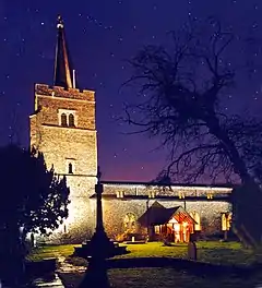
 Church of St John the Baptist, Aldenham | |
 The village green | |
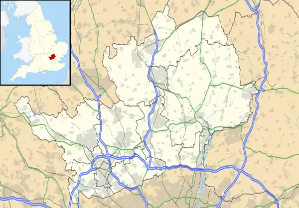
 Aldenham Location within Hertfordshire | |
| Area | 8.475 sq mi (21.95 km2) |
| Population | 9,942 (2001 census) 9,815 (2011 Census)[1] |
| • Density | 1,173/sq mi (453/km2) |
| OS grid reference | TQ138981 |
| Civil parish |
|
| District | |
| Shire county | |
| Region | |
| Country | England |
| Sovereign state | United Kingdom |
| Post town | WATFORD |
| Postcode district | WD25 |
| Dialling code | 01923 |
| Police | Hertfordshire |
| Fire | Hertfordshire |
| Ambulance | East of England |
| UK Parliament | |
In the Index of Multiple Deprivation, the ward of Aldenham East was ranked the least deprived ward out of 8414 in England, while Aldenham West also featured among the least deprived three per cent in the country. Radlett forms the eastern part of the civil parish.
History
For most recorded history Aldenham was administered together with the nearby settlement of Radlett (or at least, the Western part of that village), which until the modern era was of comparable size.[3]
In 1086 in the Domesday Book, Aldenham parish appears to have straddled the boundary of two ancient hundreds: Danish Hundred (East of North Watford, North of Patchetts Green)[4] and St. Albans Hundred (South of Hanstead).[5] The Domesday surveyors were recording a property ownership dispute that had been ongoing for three centuries regarding heavily forested land.[6]
The Church of St John the Baptist in Aldenham village is seven hundred and fifty years old and there is good reason to believe that an earlier Saxon church stood on the site. After the Reformation the lands were sold off to the highest bidders and Aldenham is probably smaller today than it was 500 years ago.
In 1940, a German air attack damaged stained glass and removed the "Hertfordshire Spike" – the spire on the top of the tower. Restoration work was completed in 1951.
Both the church and the village have been used in many films, advertisements and television programmes, being within easy travelling distance of Elstree Studios. These have included the film Confessions of a Window Cleaner, BBC television series Pathfinders, and the Coldplay music video for "Life in Technicolor II", to name but a few.
Although it gave its name to the Aldenham Bus Works owned by London Transport, Aldenham Works was actually located at nearby Elstree.
Hamlets

Round Bush
Round Bush is also on the B462 road, and lies immediately to the east, less than 300 metres (980 ft) away. Its population size and number of buildings make it a smaller settlement.[7] However, Round Bush has one pub[8] A more average (smaller) size hamlet, the centre with the vast majority of the homes due to surrounding cultivated larger sized farms – is where three roads meet at a public house.

Letchmore Heath
This is the largest hamlet, and is 0.8 miles (1.3 km) southeast, it is slightly larger in population size than the village itself, see Letchmore Heath.

Patchetts Green
On Hilfield Lane, Patchetts Green is a hamlet of several historic houses, including the Three Compasses public house,[9] Little Patchetts Green Farm[10] and Patchetts Farm.[11]
The other listed buildings here are: Delrow Cottage,[12] Delrow Almshouses[13] and Garden Cottage[14]
Crossways Cottage is just northeast of the Infant School and almshouses and is opposite the junction of the lane leading to Letchmore Heath. [15]
Other landmarks
Close to the church stand a number of buildings of historical interest. The earliest of these is Aldenham Social Club – a late medieval hall house dating from around 1500. To the west of the churchyard stands Church Farm House (16th – 18th century) and to the east the old vicarage (now two dwellings), a fine example of early 18th century red brick architecture.
The parish of Aldenham also has two British public schools: Aldenham School and the Haberdashers' Aske's Boys School (and associated girls school).
Wall Hall is a magnificent gothic revival mansion with a castellated façade created in the early nineteenth century.[16]
Sporting and leisure amenities

between Aldenham and Elstree

The golf and country park is central to the village in Church Lane.
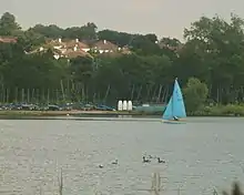
Aldenham Country Park is council-owned land which is some distance away from the old village closer to the two southern hamlets it has a 60 acres (24 ha) lake, Hillfield Reservoir and is south of Letchmore Heath.
Directly south of the country park is Aldenham Sailing Club which uses Aldenham Reservoir a 50 acres (20 ha) wide boxing glove shaped lake next to Elstree.
Notable people
- Richard Platt (died 1600), brewer, founder of Aldenham School[17]
- Sir Adolphus Dalrymple (1784–1866) lived at Delrow House, Aldenham.[18]
References
- "Civil Parish population 2011". Neighbourhood Statistics. Office for National Statistics. Retrieved 24 October 2016.
-
Historic England. "Aldenham Social Club (1103641)". National Heritage List for England. Retrieved 18 August 2012.,
Historic England. "Church (1103642)". National Heritage List for England. Retrieved 18 August 2012., the only building not at Grade II, and in fact well above Grade II* at Grade I
Historic England. "Coningesby family monument (1103643)". National Heritage List for England. Retrieved 18 August 2012.,
Historic England. "Burne family monument (1346867)". National Heritage List for England. Retrieved 18 August 2012.,
Historic England. "Corner Cottage (1296352)". National Heritage List for England. Retrieved 18 August 2012. Corner Cottage,
Historic England. "Church Farm House (1346866)". National Heritage List for England. Retrieved 18 August 2012. Church Farm House,
Historic England. "Glebe Place (1346868)". National Heritage List for England. Retrieved 18 August 2012. Glebe Place,
Historic England. "Wall Hall in Round Bush (1001455)". National Heritage List for England. Retrieved 18 August 2012. Wall Hall in Round Bush - Wratten, Donald (1997). The Book of Radlett and Aldenham (3rd edition). Baron Birch.
- Open Domesday Online: Aldenham (Danish Hundred, Hertfordshire)
- Open Domesday Online: Aldenham (St. Albans Hundred, Hertfordshire)
- British History Online: Aldenham
- Ordnance Survey, Get a Map website
- Beer In the Evening Get a Map
- Historic England. "Three Compasses (1174021)". National Heritage List for England. Retrieved 19 August 2012.
- Historic England. "Little Patchetts (1103572)". National Heritage List for England. Retrieved 19 August 2012.
- Historic England. "Patchetts (1103575)". National Heritage List for England. Retrieved 19 August 2012.
- Historic England. "Delrow Cottage (1346911)". National Heritage List for England. Retrieved 19 August 2012.
- Historic England. "Delrow Almshouses (1173191)". National Heritage List for England. Retrieved 19 August 2012.
- Historic England. "Garden Cottage (1346909)". National Heritage List for England. Retrieved 19 August 2012.
- Historic England. "Crossways Cottage / Four Want Ways (1103621)". National Heritage List for England. Retrieved 19 August 2012.
- "Wall Hall, Aldenham". Images of England, English Heritage, National Monuments Record. Retrieved 10 August 2013.
- Nicholas Carlisle, "ALDENHAM near Watford" in A Concise Description of the Endowed Grammar Schools in England, Vol. 1 (Baldwin, Cradock, and Joy, 1818), p. 528
- Stephen Wood, Dalrymple, Sir Adolphus John, second baronet (1784–1866), Oxford Dictionary of National Biography (Oxford University Press, 2004)
External links
| Wikimedia Commons has media related to Aldenham. |