Kugaaruk
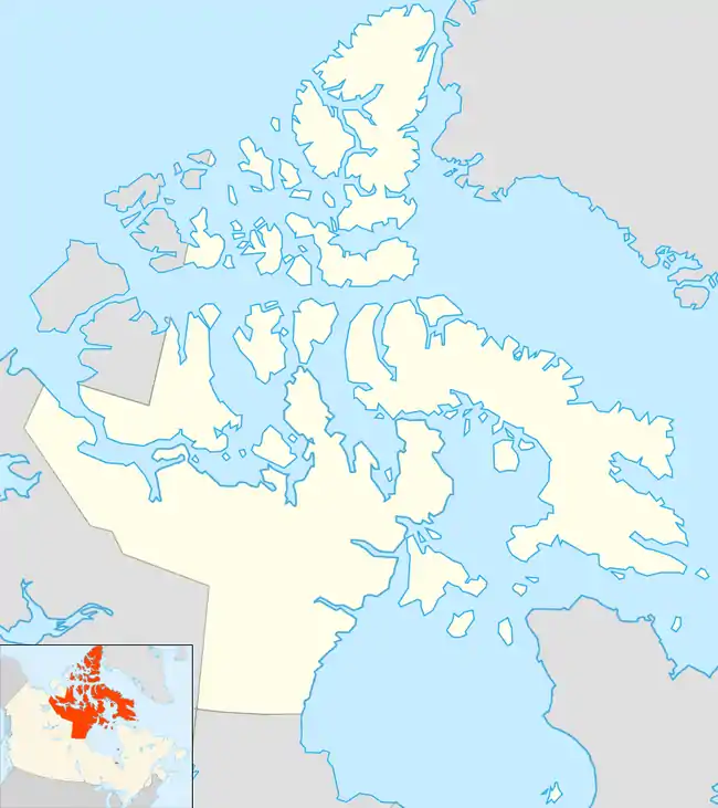
Kugaaruk (Inuktitut syllabics: ᑰᒑᕐᔪᒃ[5][6] Kuugaarjuk or ᑰᒑᕐᕈᒃ Kuugaarruk; English: "little stream") (also called Arviligjuaq, meaning "the great bowhead whale habitat"), formerly known as Pelly Bay until 3 December 1999,[5] is located on the shore of Pelly Bay, just off the Gulf of Boothia, Simpson Peninsula, Kitikmeot, in Canada's Nunavut territory. Access is by air by the Kugaaruk Airport and by annual supply sealift. Kugaaruk means "little stream",[7] the traditional name of the brook that flows through the hamlet.
Kugaaruk
ᑰᒑᕐᔪᒃ | |
|---|---|
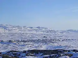 Overlooking the community | |
 Kugaaruk  Kugaaruk | |
| Coordinates: 68°31′59″N 089°49′36″W | |
| Country | Canada |
| Territory | Nunavut |
| Region | Kitikmeot |
| Electoral district | Netsilik |
| Catholic mission | 1937 |
| Government | |
| • Mayor | Teddy Apsaktaun |
| • MLA | Emilino Qirngnuq |
| Area | |
| • Total | 4.97 km2 (1.92 sq mi) |
| Elevation | 17 m (56 ft) |
| Population (2016)[3] | |
| • Total | 933 |
| • Density | 190/km2 (490/sq mi) |
| Time zone | UTC−07:00 (MST) |
| • Summer (DST) | UTC−06:00 (MDT) |
| Canadian Postal code | X0B 1K0 |
| Area code(s) | 867 |
As of the 2016 census Kugaaruk has a population of 933, a 21% increase from the 2011 census.[3]
Near the hamlet is CAM-4, a North Warning System site that was once part of the Distant Early Warning Line.
Culture

The historical inhabitants were Arviligjuarmiut.[8] Kugaaruk is a traditional "Central Inuit" community. Until 1968, the people followed a nomadic lifestyle. The population is approximately 97% Inuit and most people self-identify as Netsilik Inuit. The residents blend a land based lifestyle with modern technology and interests. Most families supplement their diet with ringed seal, caribou, and Arctic char. Other game includes narwhal, polar bear, wolverine and muskox. Despite the isolation of the community, the Inuktitut language is declining. Most people 30 and over speak Inuktitut as their first language, but the language is not being passed on to their children. In most households, a mixture of English and Inuktitut is spoken. Children understand their parents and grandparents, but respond to them in English. One goal of the Nunavut educational system is to encourage and spread the use of Inuktitut.
There are a few Inuit artists in Kugaaruk, including the world-renowned Emily Illuitok,[9] (1943-2012), who worked mostly in walrus ivory and bone; and Nick Sikkuark, whose works are mainly in whale bone, caribou antler, and walrus ivory, and are characterized by "droll, macabre wit".[10]
Most women sew traditional parkas, amautiit (baby carrying parkas), and kamik (seal or caribou skin boots).
Kugaardjuq School
Kugaardjuq School includes kindergarten to grade 12. It is very modern and includes a large south facing library, computer lab, gymnasium and science lab. Currently there are two language specialists who teach the Nattilingmiut dialect, while the rest of the staff is southern teachers. In 2010 many of the NTEP graduates, who are locals, were to become teachers in levels from kindergarten to grade 7. As the only outsiders in the community are government workers, the student population is almost entirely Inuit.[11][12]
All high schools in Nunavut use the Alberta educational curriculum. However, one challenge faced by educators in this community is that most students read at about 3 or 4 grade levels lower than their Albertan counterparts (as of 2007). As with most schools in Nunavut, the school is under the partial authority of the locally elected District Education Authority (DEA), who design policy as well as make decisions regarding discipline, spending, and cultural activities.
Kugaaruk was involved in the Mississauga YMCA exchange in 2007. 15 children from Kugaaruk made their way to Mississauga with three teachers for seven days. Then 15 people from Mississauga traveled to Kugaaruk for 11 days to experience the land and culture. Sites visited in Ontario included the CN Tower, the Hockey Hall of Fame, Queen's Park, Square One Shopping Centre, MuchMusic, Niagara Falls, Great Wolf Lodge, and the two exchange schools: Clarkson Secondary, and Hillside Senior Public School.
On 28 February 2017, the school caught on fire, described as "suspicious". Most of the school burned down, the gym, reception area and high school portion were all completely destroyed, and the elementary portion was damaged. The replacement cost was provisionally estimated between $25 to $30 million.[13]
Broadband communications
The community has been served by the Qiniq network since 2005. This is a fixed wireless service to homes and businesses, connecting to the outside world via a satellite backbone. The Qiniq network is designed and operated by SSI Micro. In 2017, the network was upgraded to 4G LTE technology, and 2G-GSM for mobile voice.
Climate
Kugaaruk is the location of the coldest wind chill ever recorded in Canada, of -79 °C[14] or -92 °C[15][16] on 13 January 1975, based on an air temperature of −51 °C (−60 °F) and a wind speed of 56 km/h (35 mph).[17][18]
On 16 February 2018, the Human Weather Observation System (HWOS), a type of semi-automated weather observing system, reported an unreviewed new minimum temperature for the month of February at −51.9 °C (−61.4 °F) at 06:00 MST.[19] It beat the previous record of −51.5 °C (−60.7 °F) that was set 28 January 1989.[20]
Kugaaruk has a tundra climate (ET) with short but cool summers and long cold winters.
| Climate data for Kugaaruk Airport | |||||||||||||
|---|---|---|---|---|---|---|---|---|---|---|---|---|---|
| Month | Jan | Feb | Mar | Apr | May | Jun | Jul | Aug | Sep | Oct | Nov | Dec | Year |
| Record high humidex | −6.7 | −9.9 | −3.5 | 1.3 | 5.4 | 25.3 | 31.2 | 25.7 | 18.4 | 6.0 | −0.7 | −1.5 | 31.2 |
| Record high °C (°F) | −7.0 (19.4) |
−10.0 (14.0) |
−3.5 (25.7) |
1.8 (35.2) |
7.5 (45.5) |
26.0 (78.8) |
27.5 (81.5) |
29.0 (84.2) |
18.5 (65.3) |
8.0 (46.4) |
0.0 (32.0) |
−2.5 (27.5) |
29.0 (84.2) |
| Average high °C (°F) | −29.9 (−21.8) |
−29.6 (−21.3) |
−24.0 (−11.2) |
−14.3 (6.3) |
−4.0 (24.8) |
6.1 (43.0) |
13.9 (57.0) |
10.1 (50.2) |
2.7 (36.9) |
−6.0 (21.2) |
−17.4 (0.7) |
−24.6 (−12.3) |
−9.7 (14.5) |
| Daily mean °C (°F) | −33.5 (−28.3) |
−33.5 (−28.3) |
−28.5 (−19.3) |
−19.4 (−2.9) |
−7.9 (17.8) |
2.9 (37.2) |
9.3 (48.7) |
6.5 (43.7) |
0.4 (32.7) |
−9.1 (15.6) |
−21.1 (−6.0) |
−28.3 (−18.9) |
−13.5 (7.7) |
| Average low °C (°F) | −37.1 (−34.8) |
−37.3 (−35.1) |
−33.0 (−27.4) |
−24.5 (−12.1) |
−11.7 (10.9) |
−0.4 (31.3) |
4.6 (40.3) |
2.9 (37.2) |
−2.0 (28.4) |
−12.1 (10.2) |
−24.9 (−12.8) |
−32.0 (−25.6) |
−17.3 (0.9) |
| Record low °C (°F) | −51.5 (−60.7) |
−49.5 (−57.1) |
−51.0 (−59.8) |
−44.5 (−48.1) |
−32.0 (−25.6) |
−15.2 (4.6) |
−1.5 (29.3) |
−5.0 (23.0) |
−14.0 (6.8) |
−31.0 (−23.8) |
−40.5 (−40.9) |
−48.5 (−55.3) |
−51.5 (−60.7) |
| Record low wind chill | −65 | −68 | −62 | −51 | −35 | −23 | 0 | −9 | −20 | −44 | −52 | −60 | −68 |
| Average precipitation mm (inches) | 9.0 (0.35) |
8.1 (0.32) |
14.1 (0.56) |
20.0 (0.79) |
18.6 (0.73) |
22.1 (0.87) |
36.5 (1.44) |
44.8 (1.76) |
28.7 (1.13) |
28.4 (1.12) |
17.7 (0.70) |
13.5 (0.53) |
261.3 (10.29) |
| Average rainfall mm (inches) | 0.0 (0.0) |
0.0 (0.0) |
0.0 (0.0) |
0.0 (0.0) |
1.1 (0.04) |
18.1 (0.71) |
36.5 (1.44) |
43.1 (1.70) |
15.2 (0.60) |
2.6 (0.10) |
0.0 (0.0) |
0.0 (0.0) |
116.6 (4.59) |
| Average snowfall cm (inches) | 9.0 (3.5) |
8.1 (3.2) |
14.1 (5.6) |
20.1 (7.9) |
17.7 (7.0) |
4.1 (1.6) |
0.0 (0.0) |
1.6 (0.6) |
13.6 (5.4) |
26.0 (10.2) |
18.4 (7.2) |
13.5 (5.3) |
146.2 (57.6) |
| Average precipitation days (≥ 0.2 mm) | 6.6 | 5.0 | 6.9 | 6.7 | 8.1 | 7.2 | 9.6 | 13.1 | 12.5 | 12.8 | 9.2 | 7.2 | 104.8 |
| Average rainy days (≥ 0.2 mm) | 0.0 | 0.0 | 0.0 | 0.0 | 0.6 | 5.9 | 9.6 | 12.8 | 6.5 | 0.6 | 0.0 | 0.0 | 36.0 |
| Average snowy days (≥ 0.2 cm) | 6.6 | 5.0 | 6.9 | 6.7 | 7.8 | 1.8 | 0.1 | 0.7 | 7.0 | 12.6 | 9.4 | 7.3 | 71.8 |
| Average relative humidity (%) | 72.7 | 78.1 | 73.2 | 80.8 | 82.9 | 77.3 | 66.4 | 72.0 | 81.2 | 85.0 | 79.0 | 78.4 | 77.2 |
| Source: Environment Canada Canadian Climate Normals 1981–2010[20] | |||||||||||||
History
First contact between Europeans and the local Inuit occurred in 1829.[21]
During colonization, Kugaaruk was named Pelly Bay after the bay on which it sits. Pelly Bay is named after Sir John Pelly, governor of the Hudson's Bay Company, company operating the British colony of Rupert's Land in which it was located when it was so named.[21]
In 1854, Scottish explorer John Rae interviewed Inuit at Pelly Bay, to document some details of a camp of the doomed Franklin Expedition that they Inuit had discovered.[22]
In 1935 Father Pierre Henry established a Roman Catholic mission at Pelly Bay. The mission changed status to being a permanent mission in 1937, with the arrival of Father Franz van de Velde. A stone church was built in 1941.[23][21]
In 1955, the Pelly Bay DEW Line Station was built near the hamlet, making the traditional campsite of nomadic Inuit into a permanent settlement.[21]
In 1968, the local airport was built, and the Canadian government imported prefab housing to build out the townsite.[21]
In 1972 the hamlet was incorporated as "Pelly Bay".[21]
In 1975, the coldest windchill ever recorded in Canada occurred, −92 °C (−134 °F) windchill on a day of −51 °C (−60 °F).[24]
In 1999 the hamlet's official name was changed to Kugaaruk.[21]
Economy and Services
- Kugaaruk Co-Op - only retail shop and hone to post office
- Koomiut Coffee Shop
- Inukshuk Inns North
- RCMP Detachment
References
- Nunavummiut vie for council positions in upcoming hamlet elections
- Election Results 2013 General Election Archived 13 November 2013 at the Wayback Machine at Elections Nunavut
- "2016 Community Profiles Kugaaruk". Retrieved 5 March 2017.
- Elevation at airport. Canada Flight Supplement. Effective 0901Z 16 July 2020 to 0901Z 10 September 2020.
- "Kugaaruk at Nunavut Tourism". Archived from the original on 15 November 2012. Retrieved 9 December 2012.
- John Ningark MLA for Kugaaruk, syllabics Archived 15 January 2013 at Archive.today, English Archived 25 May 2012 at the Wayback Machine
- ""Kugaaruk" in The Canadian Encyclopedia". Retrieved 7 October 2006.
- Bennett, 2004, chapter 26, pg. 360
- Nunavut News North: 22 January 2007
- Hessel, Ingo (2002). Inuit Art: an Introduction. Vancouver: Douglas and McIntyre. p. 119. ISBN 1-55054-829-8.
- Kugaardjuq School Archived 7 January 2009 at the Wayback Machine at the Kitikmeot Schools Operations
- Kugaardjuq School (outdated)
- "Fire in Kugaaruk, Nunavut hamlet's only school, leaves massive damage". CBC News. Retrieved 1 March 2017.
- Hourly Data Report for January 13, 1975
- The science of wind chill, CBC News, Jan. 14, 2009
- Elaine Wheaton, But it's a dry cold! (Fifth House Publishers, 1998) p48
- Christopher C. Burt and Mark Stroud, Extreme Weather: A Guide & Record Book (W. W. Norton & Company, 2007) p58
- Canada’s Wind Chill Index
- Hourly Data Report for February 16, 2018
- "Kugaaruk A". Canadian Climate Normals 1981–2010. Environment Canada. Climate ID: 2303092. Retrieved 30 April 2014.
- "Kugaaruk". Above & Beyond. 28 June 2019.
- Leann Shapton (18 March 2016). "Artifacts of a Doomed Expedition". New York Times.
- Lorraine E. Brandson (December 2002). "Franz Van De Velde, O.M.I. (1909–2002)". Arctic. 55 (4): 407–408.
- "The science of wind chill". CBC News. 14 January 2009.
Sources
- Bennett, John, and Susan Diana Mary Rowley. Uqalurait An Oral History of Nunavut. McGill-Queen's native and northern series, 36. Montreal: MQUP, 2004. ISBN 0-7735-2340-5
External links
| Wikimedia Commons has media related to Kugaaruk. |