Kwoiek Needle
Kwoiek Needle is a 2,625-metre (8,612-foot) mountain summit located in the Lillooet Ranges of southwestern British Columbia, Canada. It is situated 24 km (15 mi) southwest of Lytton, and its nearest higher peak is Kumkan Peak, 9.2 km (6 mi) to the west. The mountain was named in association with Kwoiek Creek, Kwoiek Lake, and Kwoiek Peak. Kwoiek is a Thompson Indian word meaning "gouged out," referring to a large chunk missing from the canyon wall.[3][4] The name was officially adopted on October 6, 1936, by the Geographical Names Board of Canada.[2] Meltwater from unnamed glaciers on its north slopes and precipitation runoff from the peak drains into Kwoiek Creek and Log Creek, both tributaries of the Fraser River.
| Kwoiek Needle | |
|---|---|
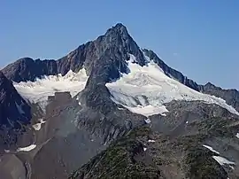 Kwoiek Needle, northeast aspect | |
| Highest point | |
| Elevation | 2,625 m (8,612 ft) [1] |
| Prominence | 595 m (1,952 ft) [1] |
| Parent peak | Kumkan Peak (2742 m)[1] |
| Coordinates | 50°05′05″N 121°48′27″W [2] |
| Geography | |
 Kwoiek Needle Location in British Columbia  Kwoiek Needle Kwoiek Needle (Canada) | |
| Location | British Columbia, Canada |
| Parent range | Lillooet Ranges Coast Ranges |
| Topo map | NTS 92.I.4 |
| Geology | |
| Age of rock | Cretaceous[1] |
| Type of rock | granodiorite[1] |
| Climbing | |
| First ascent | 1890[1] |
| Easiest route | Scrambling[1] |
Climate
Based on the Köppen climate classification, Kwoiek Needle is located in a subarctic climate zone of western North America.[5] Most weather fronts originate in the Pacific Ocean, and travel east toward the Coast Mountains where they are forced upward by the range (Orographic lift), causing them to drop their moisture in the form of rain or snowfall. As a result, the Coast Mountains experience high precipitation, especially during the winter months in the form of snowfall. Temperatures can drop below −20 °C with wind chill factors below −30 °C. The months July through September offer the most favorable weather for climbing Kwoiek Needle.
Climbing Routes
Established climbing routes on Kwoiek Needle:[1]
References
- "Kwoiek Needle". Bivouac.com. Retrieved 2019-11-20.
- "Kwoiek Needle". Geographical Names Data Base. Natural Resources Canada. Retrieved 2019-11-20.
- "Kwoiek Needle". BC Geographical Names.
- "Kwoiek Creek". BC Geographical Names.
- Peel, M. C.; Finlayson, B. L.; McMahon, T. A. (2007). "Updated world map of the Köppen−Geiger climate classification". Hydrol. Earth Syst. Sci. 11. ISSN 1027-5606.
External links
- Weather: Kwoiek Needle