La Paz Valley, Arizona
La Paz Valley is a census-designated place in La Paz County, Arizona, United States. Its population was 699 as of the 2010 census.[4] The community is in western La Paz County and is bordered to the north by the town of Quartzsite. To the south it is bordered by Yuma County.
La Paz Valley, Arizona | |
|---|---|
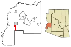 Location of La Paz Valley in La Paz County, Arizona | |
 La Paz Valley Location of La Paz Valley in La Paz County, Arizona  La Paz Valley La Paz Valley (the United States) | |
| Coordinates: 33°34′37″N 114°14′31″W | |
| Country | United States |
| State | Arizona |
| County | La Paz |
| Area | |
| • Total | 29.48 sq mi (76.35 km2) |
| • Land | 29.48 sq mi (76.35 km2) |
| • Water | 0.00 sq mi (0.00 km2) |
| Elevation | 1,027 ft (313 m) |
| Population | |
| • Total | 699 |
| • Density | 24/sq mi (9.2/km2) |
| Time zone | UTC-7 (Mountain (MST)) |
| Area code(s) | 928 |
| GNIS feature ID | 24147[3] |
| FIPS code | 04-40160 |
U.S. Route 95 forms the eastern border of the CDP and runs north into Quartzsite and south 76 miles (122 km) to Yuma. The Town of Quartzsite operates demand response buses under the name Camel Express that provide weekday service to Quartzsite and La Paz Valley.[5]
References
- "2016 U.S. Gazetteer Files". United States Census Bureau. Retrieved Jul 18, 2017.
- "U.S. Census website". United States Census Bureau. Retrieved 2011-05-14.
- "La Paz Valley". Geographic Names Information System. United States Geological Survey.
- "Geographic Identifiers: 2010 Census Summary File 1 (G001), La Paz Valley CDP, Arizona". American FactFinder. U.S. Census Bureau. Archived from the original on February 13, 2020. Retrieved August 19, 2019.
- "Public Transportation". Retrieved 2016-10-10.
- "Census of Population and Housing". Census.gov. Retrieved June 4, 2016.
Municipalities and communities of La Paz County, Arizona, United States | ||
|---|---|---|
| Towns |  | |
| CDPs | ||
| Populated places | ||
| Indian reservations | ||
| Ghost towns | ||
| ||
This article is issued from Wikipedia. The text is licensed under Creative Commons - Attribution - Sharealike. Additional terms may apply for the media files.