La Pine, Oregon
La Pine is a city in Deschutes County, Oregon, United States, incorporated on December 7, 2006.[5]
La Pine, Oregon | |
|---|---|
 La Pine City Hall | |
 Location of La Pine, Oregon | |
| Coordinates: 43°43′9″N 121°31′41″W | |
| Country | United States |
| State | Oregon |
| County | Deschutes |
| Government | |
| • Mayor | Daniel Lee Richer |
| Area | |
| • Total | 6.98 sq mi (18.09 km2) |
| • Land | 6.98 sq mi (18.09 km2) |
| • Water | 0.00 sq mi (0.00 km2) |
| Elevation | 4,236 ft (1,291 m) |
| Population | |
| • Total | 1,653 |
| • Estimate (2019)[3] | 1,929 |
| • Density | 276.20/sq mi (106.64/km2) |
| Time zone | UTC-8 (Pacific (PST)) |
| • Summer (DST) | UTC-7 (PDT) |
| ZIP code | 97739 |
| Area code(s) | 541 |
| FIPS code | 41-41050[2] |
| GNIS feature ID | 1144724[4] |
| Website | www.lapineoregon.gov |
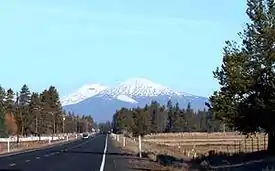
La Pine is part of the Bend, Oregon Metropolitan Statistical Area. The population was 1,653 at the 2010 census. La Pine is in an isolated area of Central Oregon, consisting of a loose collection of homes and businesses along U.S. Highway 97 about 30 miles (48 km) southwest of Bend. Several peaks of the Cascade Range are prominently visible from the community.
La Pine is in the valley of the Little Deschutes River, a tributary of the Deschutes River. The river provides recreational opportunities such as fishing, swimming, canoeing and other leisure activities.
History
La Pine was founded in the 19th century with Huntington Road as the main street. Today, La Pine is beginning to grow once again, but this time as a commuter town to Bend, making Deschutes County one of the fastest-growing counties in America.
La Pine had remained an unincorporated community for many years. A measure to incorporate in the 2000 elections was rejected by a 2–1 ratio.[6] In the elections of 2006, another incorporation measure was placed on the ballot (one of two such measures in Oregon that year; the other being for Bull Mountain, Oregon). The La Pine measure passed, creating the City of La Pine. The city occupies 7 square miles (18 km2), and at the time of incorporation in December 2006, had 1,585 residents.[7] Much of the former census-designated area lies outside the city limits.[8]
Geography
According to the United States Census Bureau, the city has a total area of 6.98 square miles (18.08 km2), all of it land.[9]
Demographics
| Historical population | |||
|---|---|---|---|
| Census | Pop. | %± | |
| 2010 | 1,653 | — | |
| 2019 (est.) | 1,929 | [3] | 16.7% |
| U.S. Decennial Census[10] | |||
2010 census
At the 2010 census, there were 1,653 people in 698 households, including 412 families, in the city. The population density was 236.8 inhabitants per square mile (91.4/km2). There were 942 housing units at an average density of 135.0 per square mile (52.1/km2). The racial makeup of the city was 93.5% White, 0.2% African American, 1.1% Native American, 0.2% Asian, 0.1% Pacific Islander, 1.8% from other races, and 3.0% from two or more races. Hispanic or Latino of any race were 5.8% of the population.[2]
Of the 698 households 28.5% had children under the age of 18 living with them, 42.6% were married couples living together, 11.6% had a female householder with no husband present, 4.9% had a male householder with no wife present, and 41.0% were non-families. 31.2% of households were one person and 15.5% were one person aged 65 or older. The average household size was 2.30 and the average family size was 2.87.[2]
The median age was 43.6 years. 22.4% of residents were under the age of 18; 6.8% were between the ages of 18 and 24; 22.7% were from 25 to 44; 30.4% were from 45 to 64; and 17.8% were 65 or older. The gender makeup of the city was 48.4% male and 51.6% female.[2]
2000 census
At the 2000 census, there were 5,799 people, 2,331 households, and 1,699 families in the CDP. The population density was 197.7 people per square mile (76.3/km2). There were 2,975 housing units at an average density of 101.4 per square mile (39.2/km2). The racial makeup of the CDP was 95.84% White, 0.09% African American, 1.28% Native American, 0.24% Asian, 0.10% Pacific Islander, 0.55% from other races, and 1.90% from two or more races. Hispanic or Latino of any race were 2.22% of the population.[2]
Of the 2,331 households 26.6% had children under the age of 18 living with them, 61.3% were married couples living together, 7.3% had a female householder with no husband present, and 27.1% were non-families. 20.8% of households were one person and 10.3% were one person aged 65 or older. The average household size was 2.47 and the average family size was 2.82.[2]
The age distribution was 23.0% under the age of 18, 4.9% from 18 to 24, 22.5% from 25 to 44, 28.8% from 45 to 64, and 20.7% 65 or older. The median age was 45 years. For every 100 females, there were 99.8 males. For every 100 females age 18 and over, there were 98.7 males.[2]
The median household income was $29,859 and the median family income was $33,938. Males had a median income of $30,457 versus $20,186 for females. The per capita income for the CDP was $15,543. About 9.5% of families and 13.2% of the population were below the poverty line, including 13.4% of those under age 18 and 11.5% of those age 65 or over.[2]
Education
La Pine schools are part of the Bend-La Pine School District.[11]
References
- "2019 U.S. Gazetteer Files". United States Census Bureau. Retrieved July 28, 2020.
- "U.S. Census website". United States Census Bureau. Retrieved 2012-12-21.
- "Population and Housing Unit Estimates". United States Census Bureau. May 24, 2020. Retrieved May 27, 2020.
- "US Board on Geographic Names". United States Geological Survey. 2007-10-25. Retrieved 2008-01-31.
- Population Estimates Boundary Changes Archived 2006-02-06 at the Wayback Machine, United States Census Bureau, 2007-07-01. Accessed 2008-11-06.
- "La Pine: Incorporation measure is headed to passage", The Oregonian, November 5, 2006, pg. A4.
- Population Research Center. Portland State University. Retrieved October 5, 2007.
- http://www.kgw.com/sharedcontent/APStories/stories/D8L9EVDO0.html%5B%5D
- "US Gazetteer files 2010". United States Census Bureau. Archived from the original on 2012-01-25. Retrieved 2012-12-21.
- "Census of Population and Housing". Census.gov. Retrieved June 4, 2015.
- Bend-La Pine School District
External links
Municipalities and communities of Deschutes County, Oregon, United States | ||
|---|---|---|
| Cities | 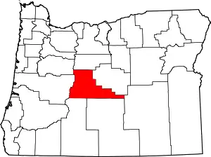 Deschutes County map | |
| CDPs | ||
| Other unincorporated communities | ||
| ||
| Authority control |
|---|
