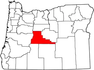
Deschutes County, Oregon
Deschutes County /dəˈʃuːts/ is one of the 36 counties in the U.S. state of Oregon. As of the 2010 census, the population was 157,733.[1] The county seat is Bend.[2] The county was created in 1916 out of part of Crook County and was named for the Deschutes River, which itself was named by French-Canadian trappers of the early 19th century. It is the political and economic hub of Central Oregon. Deschutes comprises the Bend, OR Metropolitan Statistical Area.[3] Deschutes is Oregon’s fastest-growing county.[4]
Deschutes County | |
|---|---|
 | |
 Location within the U.S. state of Oregon | |
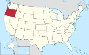 Oregon's location within the U.S. | |
| Coordinates: 43°55′N 121°13′W | |
| Country | |
| State | |
| Founded | December 13, 1916 |
| Named for | Deschutes River |
| Seat | Bend |
| Largest city | Bend |
| Area | |
| • Total | 3,055 sq mi (7,910 km2) |
| • Land | 3,018 sq mi (7,820 km2) |
| • Water | 37 sq mi (100 km2) 1.2%% |
| Population (2010) | |
| • Total | 157,733 |
| • Estimate (2019) | 197,692 |
| • Density | 52/sq mi (20/km2) |
| Time zone | UTC−8 (Pacific) |
| • Summer (DST) | UTC−7 (PDT) |
| Congressional district | 2nd |
| Website | www |
History
French-Canadian fur trappers of the Hudson's Bay Company gave the name Riviere des Chutes (River of the Falls) to the Deschutes River, from which the county derived its name.[5]
On December 13, 1916, Deschutes County was created from the southern part of Crook County. Bend has been the county seat since the county's formation. It was the last county in Oregon to be established.
The Shevlin-Hixon Lumber Company also operated within the Bend area processing Ponderosa pine trees.
Geography
According to the U.S. Census Bureau, the county has a total area of 3,055 square miles (7,910 km2), of which 3,018 square miles (7,820 km2) is land and 37 square miles (96 km2) (1.2%) is water.[6]
Adjacent counties
- Linn County (northwest)
- Jefferson County (north)
- Crook County (east)
- Harney County (southeast)
- Lake County (south)
- Klamath County (south)
- Lane County (west)
National protected areas
Demographics
| Historical population | |||
|---|---|---|---|
| Census | Pop. | %± | |
| 1920 | 9,622 | — | |
| 1930 | 14,749 | 53.3% | |
| 1940 | 18,631 | 26.3% | |
| 1950 | 21,812 | 17.1% | |
| 1960 | 23,100 | 5.9% | |
| 1970 | 30,442 | 31.8% | |
| 1980 | 62,142 | 104.1% | |
| 1990 | 74,958 | 20.6% | |
| 2000 | 115,367 | 53.9% | |
| 2010 | 157,733 | 36.7% | |
| 2019 (est.) | 197,692 | [7] | 25.3% |
| U.S. Decennial Census[8] 1790-1960[9] 1900-1990[10] 1990-2000[11] 2010-2019[1] | |||
2000 census
As of the census[12] of 2000, there were 115,367 people, 45,595 households, and 31,962 families living in the county. The population density was 38 people per square mile (15/km2). There were 54,583 housing units at an average density of 18 per square mile (7/km2). The racial makeup of the county was 94.85% White, 0.19% Black or African American, 0.83% Native American, 0.74% Asian, 0.07% Pacific Islander, 1.36% from other races, and 1.96% from two or more races. 3.73% of the population were Hispanic or Latino of any race. 19.4% were of German, 13.2% English, 11.4% Irish and 9.1% American ancestry.
There were 45,595 households, out of which 32.10% had children under the age of 18 living with them, 58.00% were married couples living together, 8.50% had a female householder with no husband present, and 29.90% were non-families. 22.00% of all households were made up of individuals, and 7.70% had someone living alone who was 65 years of age or older. The average household size was 2.50 and the average family size was 2.91.
In the county, the population was spread out, with 24.80% under the age of 18, 7.80% from 18 to 24, 28.60% from 25 to 44, 25.70% from 45 to 64, and 13.10% who were 65 years of age or older. The median age was 38 years. For every 100 females there were 98.70 males. For every 100 females age 18 and over, there were 97.00 males.
The median income for a household in the county was $41,847, and the median income for a family was $48,403. Males had a median income of $34,070 versus $25,069 for females. The per capita income for the county was $21,767. About 6.30% of families and 9.30% of the population were below the poverty line, including 10.40% of those under age 18 and 6.10% of those age 65 or over.
2010 census
As of the 2010 United States Census, there were 157,733 people, 64,090 households, and 43,062 families living in the county.[13] The population density was 52.3 inhabitants per square mile (20.2/km2). There were 80,139 housing units at an average density of 26.6 per square mile (10.3/km2).[14] The racial makeup of the county was 92.2% white, 0.9% Asian, 0.9% American Indian, 0.4% black or African American, 0.1% Pacific islander, 3.0% from other races, and 2.5% from two or more races. Those of Hispanic or Latino origin made up 7.4% of the population.[13] In terms of ancestry, 24.0% were German, 15.3% were Irish, 14.5% were English, and 4.8% were American.[15]
Of the 64,090 households, 30.8% had children under the age of 18 living with them, 53.4% were married couples living together, 9.4% had a female householder with no husband present, 32.8% were non-families, and 24.1% of all households were made up of individuals. The average household size was 2.44 and the average family size was 2.88. The median age was 40.2 years.[13]
The median income for a household in the county was $53,071 and the median income for a family was $61,605. Males had a median income of $43,543 versus $33,207 for females. The per capita income for the county was $27,920. About 7.6% of families and 10.5% of the population were below the poverty line, including 14.9% of those under age 18 and 7.7% of those age 65 or over.[16]
Politics
Deschutes County politically falls more in line with the eastern side of Oregon than the western side. A plurality of registered voters who are part of a political party in Deschutes County, as with most counties in eastern Oregon, are members of the Republican Party.[17] In the 2012 presidential election, Republican Mitt Romney won 51.85% of the vote in Deschutes County to 45.13% for President Barack Obama, the Democratic Party's nominee.[18] However, in the 2008 presidential election, Obama lost Deschutes County more narrowly, garnering 48.66% of the vote versus 48.96% for Republican John McCain.[19] Both the 2008 and 2012 results represented a significant shift towards the Democratic candidate when compared to the 2004 presidential election, in which 56.4% of Deschutes Country voters voted for Republican President George W. Bush, while 42.1% voted for Democratic challenger John Kerry, and 1.5% of voters either voted for a third-party candidate or wrote in a candidate.[20] In 2020, Joe Biden became the first Democratic candidate to win the county since 1992, and the first to receive a majority of votes since 1964.
In 2008, the Oregon house seat encompassing the city of Bend switched parties and hosted the only Democratic state legislator from a district east of the Cascades,[21] though the Republicans retook the seat in 2010.[22] Republicans would hold the seat for the remainder of the decade until 2020, when Democrat Jason Kropf was elected to the State House.
.gif)
| Year | Republican | Democratic | Third parties |
|---|---|---|---|
| 2020 | 44.4% 55,646 | 52.7% 65,962 | 2.9% 3,626 |
| 2016 | 46.4% 45,692 | 43.1% 42,444 | 10.6% 10,421 |
| 2012 | 51.9% 42,463 | 45.1% 36,961 | 3.0% 2,476 |
| 2008 | 49.0% 39,064 | 48.7% 38,819 | 2.4% 1,899 |
| 2004 | 56.4% 41,757 | 42.1% 31,179 | 1.5% 1,112 |
| 2000 | 55.5% 32,132 | 38.1% 22,061 | 6.4% 3,692 |
| 1996 | 46.7% 21,135 | 37.9% 17,151 | 15.5% 6,996 |
| 1992 | 35.7% 15,655 | 35.7% 15,693 | 28.6% 12,570 |
| 1988 | 52.4% 16,425 | 45.5% 14,264 | 2.2% 677 |
| 1984 | 62.2% 19,323 | 37.6% 11,671 | 0.2% 72 |
| 1980 | 52.9% 15,186 | 33.6% 9,641 | 13.5% 3,888 |
| 1976 | 46.7% 9,054 | 48.9% 9,480 | 4.4% 848 |
| 1972 | 52.3% 7,747 | 42.6% 6,319 | 5.1% 753 |
| 1968 | 49.9% 5,599 | 43.3% 4,859 | 6.9% 772 |
| 1964 | 31.2% 3,148 | 68.8% 6,947 | 0.0% 0 |
| 1960 | 51.7% 5,145 | 48.0% 4,776 | 0.2% 23 |
| 1956 | 56.8% 5,399 | 43.2% 4,102 | |
| 1952 | 64.3% 5,776 | 35.3% 3,174 | 0.4% 36 |
| 1948 | 48.4% 3,463 | 48.9% 3,499 | 2.8% 201 |
| 1944 | 39.6% 2,547 | 59.2% 3,807 | 1.1% 72 |
| 1940 | 34.9% 2,603 | 64.1% 4,775 | 1.0% 75 |
| 1936 | 22.1% 1,299 | 72.7% 4,278 | 5.2% 307 |
| 1932 | 33.6% 1,697 | 58.6% 2,962 | 7.8% 396 |
| 1928 | 60.8% 2,815 | 36.8% 1,702 | 2.4% 111 |
| 1924 | 53.0% 2,321 | 23.2% 1,015 | 23.8% 1,042 |
| 1920 | 54.2% 1,649 | 35.3% 1,072 | 10.5% 319 |
Economy
During the 1990s, Deschutes County experienced the most rapid growth of any county in Oregon, largely due to the year-round availability of recreational activities, and its location as the nearest population center to much of the central Cascade Range. Beyond tourism, principal industries in the county are lumber, ranching and agriculture—chiefly potatoes. The Forest Service owns 51% of the lands within the county boundaries.
Deschutes County is the home of four destination resorts as defined by Oregon's Department of Land Conservation and Development. These resorts are major employers within the county. Three of these resorts, Sunriver, Eagle Crest, and Pronghorn, are among the county's ten largest tax payers.[24]
Geology
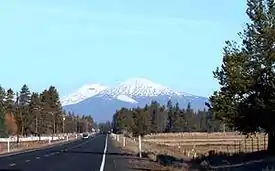
The overall defining landscape of Deschutes County is primarily marked with that of lava flows. Most of the lava found in Deschutes County issued forth from Newberry Volcano located just south of Bend. Because of this, many lava tubes are located within, including the prominent Lava River Cave. As a consequence, the county is the most cave-rich in the state of Oregon,[25] with over 500 known caves in the county.[26] Other prominent lava flows exist too, especially those related to the Mount Bachelor Volcanic Chain which consists of Mt. Bachelor as well as three smaller shield volcanos, and a series of cinder cones.[27]
Large volcanoes serve as a backdrop to the city of Bend in Deschutes County, ranging from the prominent Three Sisters, Mt. Washington, Mt. Bachelor, Broken Top, Newberry, Tumalo Mountain, Maiden Peak and others. A group of geologists have discovered Smith Rock State Park is part of an ancient supervolcano called the Crooked River caldera with a rim nearly six times the diameter of Newberry Volcano's caldera. This ancient supervolcano has long gone extinct. Its crater rim is barely recognizable as remnants mark portions of Powell Buttes, Gray Butte, and the western front of the Ochoco Mountains at Barnes Butte.[28]
On the eastern side of the county, it is mostly characterized by large buttes of much older volcanic origin. Most of these did not create any proper lava flows, or at least none that are known to exist. Some of the prominent buttes include Horse Ridge, Pine Mountain, China Hat, and several others on the county border.
Two main types of lava flows are found within the county. The most common are the pāhoehoe flows which have been partially buried by volcanic ash, tephra deposits, and dirt over tens to hundreds of thousands of years. The ʻaʻā flows are fewer but much more prominent, with the most notable being associated with Lava Butte and the Lava Cast Forest in the Newberry National Volcanic Monument.
References
- "State & County QuickFacts". United States Census Bureau. Archived from the original on June 20, 2011. Retrieved November 14, 2013.
- "Find a County". National Association of Counties. Archived from the original on May 31, 2011. Retrieved June 7, 2011.
- "OMB Bulletin No. 20-01: Revised Delineations of Metropolitan Statistical Areas, Micropolitan Statistical Areas, and Combined Statistical Areas, and Guidance on Uses of the Delineations of These Areas" (PDF). United States Office of Management and Budget. March 6, 2020. Retrieved April 25, 2020.
- Bilby, Robert; Hanna, Susan; Huntly, Nancy; et al. (July 8, 2007). "Human Population Impacts on Columbia River Basin Fish and Wildlife" (PDF). Independent Scientific Advisory Board. Archived from the original (PDF) on January 17, 2013. Retrieved September 15, 2008.
- "Deschutes County". Oregon Blue Book. State of Oregon. Retrieved April 10, 2009.
- "2010 Census Gazetteer Files". United States Census Bureau. August 22, 2012. Retrieved February 25, 2015.
- "Population and Housing Unit Estimates". Retrieved March 26, 2020.
- "U.S. Decennial Census". United States Census Bureau. Retrieved February 25, 2015.
- "Historical Census Browser". University of Virginia Library. Retrieved February 25, 2015.
- Forstall, Richard L., ed. (March 27, 1995). "Population of Counties by Decennial Census: 1900 to 1990". United States Census Bureau. Retrieved February 25, 2015.
- "Census 2000 PHC-T-4. Ranking Tables for Counties: 1990 and 2000" (PDF). United States Census Bureau. April 2, 2001. Retrieved February 25, 2015.
- "U.S. Census website". United States Census Bureau. Retrieved January 31, 2008.
- "DP-1 Profile of General Population and Housing Characteristics: 2010 Demographic Profile Data". United States Census Bureau. Archived from the original on February 13, 2020. Retrieved February 23, 2016.
- "Population, Housing Units, Area, and Density: 2010 - County". United States Census Bureau. Archived from the original on February 13, 2020. Retrieved February 23, 2016.
- "DP02 SELECTED SOCIAL CHARACTERISTICS IN THE UNITED STATES – 2006-2010 American Community Survey 5-Year Estimates". United States Census Bureau. Archived from the original on February 13, 2020. Retrieved February 23, 2016.
- "DP03 SELECTED ECONOMIC CHARACTERISTICS – 2006-2010 American Community Survey 5-Year Estimates". United States Census Bureau. Archived from the original on February 13, 2020. Retrieved February 23, 2016.
- "Deschutes County Election Results 2012". Deschutes.org. Archived from the original on February 22, 2014. Retrieved February 3, 2014.
- "Deschutes County Election Results 2008". Deschutes.org. Archived from the original on February 19, 2012. Retrieved April 22, 2009.
- "Deschutes County, Oregon (OR)". City-data.com. Retrieved October 24, 2012.
- Archived October 7, 2011, at the Wayback Machine
- "Jason Conger - Oregon State Representative, House District 54". Repjasonconger.com. Archived from the original on March 28, 2012. Retrieved August 6, 2012.
- Leip, David. "Dave Leip's Atlas of U.S. Presidential Elections". uselectionatlas.org. Retrieved April 11, 2018.
- Williams, Steve, "The Expansion of Oregon’s Destination Resorts", WorkSource Oregon, www.qualityinfo.org, Oregon Employment Department, Salem, Oregon, 29 March 2007.
- "Oregon High Desert Grotto". Ohdgrotto.com. Retrieved October 24, 2012.
- Matt Skeels. "The Caves of Central Oregon". Oregon High Desert Grotto. Retrieved July 7, 2013.
- Geologic Map of the Mount Bachelor Volcanic Chain and Surrounding Area, Cascade Range, Oregon (Map). 1 : 50,000. Cartography by D. F. Garcia; R. C. Ittner; S.E. Jefferies. U.S. Department of the Interior; U.S. Geological Survey; Scott, William E.; Gardner, Cynthia A. 1992.
- McClaughry, Jason D.; Ferns, Mark L.; Gordon, Caroline L.; Patridge, Karyn A. (2009). "Field Trip Guide to the Oligocene Crooked River caldera: Central Oregon's Supervolcano, Crook, Deschutes, and Jefferson Counties, Oregon" (PDF). Oregon Geology. 69 (1): 25–44. Archived from the original (PDF) on July 27, 2011. Retrieved October 20, 2009.
Further reading
- Turnbull, George S. (1939). . . Binfords & Mort.
Places adjacent to Deschutes County, Oregon | ||||||||||
|---|---|---|---|---|---|---|---|---|---|---|
| ||||||||||
Municipalities and communities of Deschutes County, Oregon, United States | ||
|---|---|---|
| Cities | Deschutes County map | |
| CDPs | ||
| Other unincorporated communities | ||
| ||

| Authority control |
|---|