Redmond, Oregon
Redmond is a city in Deschutes County, Oregon, United States. Incorporated on July 6, 1910, the city is on the eastern side of Oregon's Cascade Range, in the High Desert in Central Oregon. From Redmond there is access to recreational opportunities. Redmond is a full-service municipality and one of the fastest-growing industrial and residential communities in Oregon. Redmond had a population of 32,421 in 2019, and the population continues to grow at a rate of about 6.7 percent each year.
Redmond | |
|---|---|
| Redmond, Oregon | |
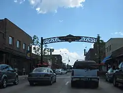 Business Highway 97 in Redmond | |
 Seal | |
| Nickname(s): The Hub and Central Plaza | |
| Motto(s): The Heart of Central Oregon | |
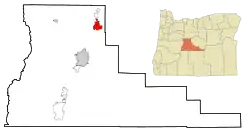 Location in Oregon | |
| Coordinates: 44°16′8″N 121°11′1″W | |
| Country | United States |
| State | Oregon |
| County | Deschutes |
| Incorporated | 1910 |
| Government | |
| • Type | Council-manager |
| • Mayor | George Endicott |
| Area | |
| • City | 16.68 sq mi (43.21 km2) |
| • Land | 16.68 sq mi (43.21 km2) |
| • Water | 0.00 sq mi (0.00 km2) |
| Elevation | 3,077 ft (938 m) |
| Population | |
| • City | 26,215 |
| • Estimate (2019)[3] | 32,421 |
| • Density | 1,943.36/sq mi (750.34/km2) |
| • Urban | 83,794 |
| • Metro | 165,954 |
| Time zone | UTC-8 (Pacific) |
| • Summer (DST) | UTC-7 (Pacific) |
| ZIP code | 97756 |
| Area code(s) | 541 |
| FIPS code | 41-61200[2] |
| GNIS feature ID | 1125912[4] |
| Website | www.ci.redmond.or.us |
The city encompasses 15.5 square miles (40 km2) and is on a plateau, at an elevation of 3,077 feet (938 m). Redmond is 15 miles (24 km) north of Bend—the county seat of Deschutes County—144 miles (232 km) from Portland, 129 miles (208 km) from Salem—the capital of Oregon—and 126 miles (203 km) from Eugene.
History
Redmond was named after Frank T. Redmond, who settled in the area in 1905.[5] It was platted in 1906 by a company which would become part of Central Oregon Irrigation District building a canal.[6] Electrification and the Oregon Trunk Railway reached Redmond in 1911. The rail link opened markets for farmers and merchants. By 1930, the town had grown to 1,000 and by 1940 had nearly doubled. In the 1940s, Redmond was a U.S. Army Air base and commercial air service was established at Roberts Field after World War II. In the 1950s, 60s, 70s, and most of the 80s, the population remained relatively static, growing slowly around a small commercial/retail center and manufacturing industry. However, during the 1990s, the population began to grow along with most of Deschutes County. Between 2000 and 2006, Redmond's population grew 74.3%, making it among Oregon's fastest-growing cities each year. This growth continued through 2006, increasing the population to 23,500. Its growth is fueled by employment and a lower cost of living.
Geography
The Horse Lava Tube System enters the city at the point of the Redmond Caves. The lava flow that created the system continues into the Redmond Canyon and beyond.[7][8]
Climate
Redmond's climate is typical of the high desert with cool nights and sunny days. Annual precipitation averages between 8 and 10 inches (200 and 250 mm), with an average annual snowfall of 24 inches (61 cm). The winter season in Redmond provides typical daytime temperatures between 10 °F (−12 °C) and 40 °F (4 °C). Average nighttime temperatures range anywhere from 0 °F (−18 °C) to 40 °F (4 °C). According to the USDA Plant Hardiness Zone Map,[9] the average annual extreme minimum temperature in Redmond is −5 °F (−21 °C) to −10 °F (−23 °C).[10]
A typical Central Oregon summer is marked with daily temperatures around 75 °F (24 °C) to 100 °F (38 °C) during the day, and around 40 °F (4 °C) to 60 °F (16 °C) during the night. Hard frosts happen on occasion during the summer months. Autumn usually brings warm, dry days and cooler nights. According to the Western Regional Climate Center of the Desert Research Institute, the mean of the monthly average maximum temperatures in July, the hottest month in Redmond, between 1928 and 2006 was 82.09 °F (27.83 °C).[11]
Redmond's growing season is short. According to the U.S. Department of Agriculture's National Resources Conservation Service, in half of the years between 1971 and 2000, the USDA weather station in Redmond recorded the last below-freezing temperatures after July 3 and the first below-freezing temperatures before August 31.[12] Redmond has a steppe climate (BSk) according to the Köppen climate classification system.
| Climate data for Redmond | |||||||||||||
|---|---|---|---|---|---|---|---|---|---|---|---|---|---|
| Month | Jan | Feb | Mar | Apr | May | Jun | Jul | Aug | Sep | Oct | Nov | Dec | Year |
| Record high °F (°C) | 67 (19) |
73 (23) |
80 (27) |
89 (32) |
99 (37) |
101 (38) |
105 (41) |
108 (42) |
105 (41) |
95 (35) |
76 (24) |
67 (19) |
108 (42) |
| Average high °F (°C) | 41.7 (5.4) |
47 (8) |
52.7 (11.5) |
59.4 (15.2) |
67.1 (19.5) |
75.6 (24.2) |
85.5 (29.7) |
84 (29) |
76.2 (24.6) |
64 (18) |
49.6 (9.8) |
42.3 (5.7) |
62.1 (16.7) |
| Average low °F (°C) | 22.2 (−5.4) |
24.7 (−4.1) |
26.2 (−3.2) |
29.2 (−1.6) |
35.4 (1.9) |
41.9 (5.5) |
46.7 (8.2) |
45.7 (7.6) |
39.1 (3.9) |
32.2 (0.1) |
26.9 (−2.8) |
22.4 (−5.3) |
32.7 (0.4) |
| Record low °F (°C) | −27 (−33) |
−19 (−28) |
−1 (−18) |
10 (−12) |
12 (−11) |
24 (−4) |
28 (−2) |
25 (−4) |
16 (−9) |
−3 (−19) |
−14 (−26) |
−28 (−33) |
−28 (−33) |
| Average precipitation inches (mm) | 1.06 (27) |
0.67 (17) |
0.66 (17) |
0.57 (14) |
0.98 (25) |
0.79 (20) |
0.4 (10) |
0.47 (12) |
0.39 (9.9) |
0.62 (16) |
0.97 (25) |
1.06 (27) |
8.64 (219) |
| Average snowfall inches (cm) | 6.3 (16) |
3.1 (7.9) |
2 (5.1) |
0.8 (2.0) |
0 (0) |
0.1 (0.25) |
0 (0) |
0 (0) |
0 (0) |
0.1 (0.25) |
2.6 (6.6) |
4.7 (12) |
19.7 (50) |
| Average precipitation days | 9 | 7 | 8 | 7 | 7 | 6 | 3 | 3 | 4 | 6 | 9 | 9 | 78 |
| Source: [13] | |||||||||||||
Demographics
| Historical population | |||
|---|---|---|---|
| Census | Pop. | %± | |
| 1910 | 216 | — | |
| 1920 | 585 | 170.8% | |
| 1930 | 994 | 69.9% | |
| 1940 | 1,876 | 88.7% | |
| 1950 | 2,956 | 57.6% | |
| 1960 | 3,340 | 13.0% | |
| 1970 | 3,721 | 11.4% | |
| 1980 | 6,452 | 73.4% | |
| 1990 | 7,163 | 11.0% | |
| 2000 | 13,481 | 88.2% | |
| 2010 | 26,215 | 94.5% | |
| 2019 (est.) | 32,421 | [3] | 23.7% |
| [2][14][15] 2018 Estimate[17] | |||
2010 census
As of the census of 2010, there were 26,215 people, 9,947 households, and 6,789 families residing in the city. The population density was 1,561.3 inhabitants per square mile (602.8/km2). There were 10,965 housing units at an average density of 653.1 per square mile (252.2/km2). The racial makeup of the city was 89.0% White, 0.4% African American, 1.3% Native American, 0.8% Asian, 0.2% Pacific Islander, 5.4% from other races, and 2.9% from two or more races. Hispanic or Latino of any race were 12.5% of the population.[2]
There were 9,947 households, of which 38.6% had children under the age of 18 living with them, 48.7% were married couples living together, 13.9% had a female householder with no husband present, 5.6% had a male householder with no wife present, and 31.7% were non-families. 24.0% of all households were made up of individuals, and 9.6% had someone living alone who was 65 years of age or older. The average household size was 2.61 and the average family size was 3.07.[2]
The median age in the city was 33.9 years. 27.9% of residents were under the age of 18; 8.8% were between the ages of 18 and 24; 28.8% were from 25 to 44; 21.9% were from 45 to 64; and 12.7% were 65 years of age or older. The gender makeup of the city was 48.3% male and 51.7% female.[2]
2000 census
At the census of 2000, there were 13,481 people, 5,260 households, and 3,618 families residing in the city. The population density was 1,316.7 per square mile (508.3/km2). There were 5,584 housing units at an average density of 545.4 per square mile (210.5/km2). The racial makeup was 93.72% White, 0.09% African American, 1.16% Native American, 0.65% Asian, 0.16% Pacific Islander, 2.14% from other races, and 2.08% from two or more races. Hispanic or Latino of any race were 5.48% of the population.[2]
There were 5,260 households, of which 38.1% had children under 18 living with them, 52.2% were married couples living together, 12.2% had a female householder with no husband present, and 31.2% were non-families. 24.6% of all households were of individuals and 10.6% had someone living alone who was 65 or older. The average household size was 2.54 and the average family size 3.02.[2]
In the city, the population was 29.6% under 18, 8.6% from 18 to 24, 30.6% from 25 to 44, 18.3% from 45 to 64, and 13.0% who were 65 or older. The median age was 33. For every 100 females, there were 93.1 males. For every 100 females 18 and over, there were 88.0 males.[2]
The median income for a household was $33,701, and the median income for a family $41,481. Males had a median of $31,940 versus $23,508 for females. The per capita income was $16,286. About 6.6% of families and 9.7% of the population were below the poverty line, including 8.9% of those under 18 and 7.5% of those 65 or over.[2]
Economy
A major employer is Redmond Air Center, at the Redmond Airport. This is a Forest Service smoke-jumping, firefighting and training installation.
T-Mobile USA had a call center in Redmond which employed more than 700.[18] T-Mobile made plans to close this facility in June 2013,[19] but Oregon-based Consumer Cellular moved to sublease the call center and rehire some of T-Mobile's former employees.[20] The Consumer Cellular call center currently employs more than 200 people, with plans to grow the facility to 650 employees.[21][22]
The Redmond Spokesman newspaper is the city's oldest continuously operating business, printing its first issue July 14, 1910. Publishers Henry and Clara Palmer moved their press for the Laidlaw Chronicle to Redmond, competing with the existing Oregon Hub and Enterprise newspapers, now defunct.[23]
The Eagle Crest Resort, 6 miles (10 km) west of Redmond, is one of eight destination resorts as defined by Oregon's Department of Land Conservation and Development. Eagle Crest is one of Redmond's major employers, and one of Deschutes County's largest corporate tax payers.[24]
Education
Redmond's total enrollment on September 26, 2006, was 6,892.
- Redmond School District elementary schools serve grades K–5, middle school grades 6–8 and high school 9–12.Redmond School District encompasses 556 square miles (1,400 km2) and operates the following 11 schools:
- 7 elementary schools, serving grades K–5
- 2 middle schools, serving grades 6–8
- 2 high schools, serving grades 9–12
- Private institutions:
- One private Christian school, serving grades pre-kindergarten to 12
- Redmond Proficiency Academy, a grades 6–12 charter school, serving students from Redmond and the greater Central Oregon area
- George Fox University, affiliated or associated with the Evangelical Friends Alliance
Transportation

Air
Redmond is the location of the region's only commercial airline service airport, Roberts Field. Air carriers include Alaska Airlines, American Airlines, Delta Air Lines and United Airlines with service operated by their respective regional airline affiliates via code sharing agreements. These carriers provide nonstop service to Portland, Seattle, Denver, Salt Lake City, Los Angeles, San Francisco and Phoenix. The U.S. Forest Service operates an air base and training center for firefighting, and Butler Aircraft, a fixed-base operator, flies DC-7 aircraft for firefighting efforts.
Highways
Redmond lies at the intersection of U.S. Route 126 and U.S. Route 97. The latter runs on an expressway alignment through the city known as the Redmond Parkway.
Rail
A BNSF main line runs north-south through the city; there are numerous spurs off of the main line which serve industrial rail customers. The closest Amtrak service is in the town of Chemult, approximately 75 miles (121 km) to the south; this station is served by the Coast Starlight route.
Points of interest
Natural history
Some of Redmond's landmark desert flora include:
Notable people
- Les AuCoin, a nine-term member of the U.S. House of Representatives from Oregon's First District, grew up in Redmond, attending the city's public schools from the first grade until graduation from Redmond Union High School (as it was called then) in 1960.
- Sam Johnson, a longtime member of the Oregon House of Representatives, was elected mayor of Redmond in 1979 and served in that capacity until his death in 1984.[25]
- Tom McCall, the 30th Governor of Oregon (from 1967 to 1975), graduated from Redmond High School.[26]
- James F. Short, (1902-1986) businessman, rancher, and state legislator[27]
- Arthur Tuck, an American track and field athlete who singlehandedly won the 1919 Oregon state high school track and field team championship for Redmond High School.[28]
- Jill Twiss, an American actress, writer and comedian known for her work on the HBO show Last Week Tonight with John Oliver and author of the bestselling children's book A Day in the Life of Marlon Bundo.
References
- "2019 U.S. Gazetteer Files". United States Census Bureau. Retrieved July 28, 2020.
- "U.S. Census website". United States Census Bureau. Retrieved 2012-12-21.
- "Population and Housing Unit Estimates". United States Census Bureau. May 24, 2020. Retrieved May 27, 2020.
- "US Board on Geographic Names". United States Geological Survey. 2007-10-25. Retrieved 2008-01-31.
- McArthur, Lewis A.; McArthur, Lewis L. (2003). Oregon Geographic Names. Portland: Oregon Historical Society Press. p. 802. ISBN 0-87595-278X.
- McArthur, Lewis A.; McArthur, Lewis L. (2003). Oregon Geographic Names (Seventh ed.). OHS Press. p. 802. ISBN 0875952771. Retrieved 2014-10-10.
- Skeels (2009-02-13). "Horse Lava Tube System". Archived from the original on 2009-12-13. Retrieved 2009-07-05.
- Champion, Duane E. (2002-05-14). "Mapping Newberry Volcano's Extensive North Flank Basalts". Retrieved 2009-07-27.
- "Washington USDA Hardiness Zone Map". Retrieved 2010-11-28.
- Ramon Jordan (2012-01-24). "USNA - USDA Plant Hardiness Zone Map: North-West US". Usna.usda.gov. Archived from the original on 2013-12-10. Retrieved 2013-11-28.
- "Monthly Average Maximum Temperature, BEND, OREGON". Wrcc.dri.edu. 2006-07-25. Retrieved 2013-11-28.
- "National Water & Climate Center - Climate Information". Wcc.nrcs.usda.gov. Archived from the original on 2014-07-13. Retrieved 2013-11-28.
- "REDMOND ROBERTS FLD, OR (357062)". Western Regional Climate Center. Retrieved November 26, 2015.
- "Population by City, 2000 and 2010". Population Research Center. Portland State University. Retrieved 2011-07-28.
- Moffatt, Riley. Population History of Western U.S. Cities & Towns, 1850–1990. Lanham: Scarecrow, 1996, 215.
- United States Census Bureau. "Census of Population and Housing". Retrieved September 26, 2014.
- "Population Estimates". United States Census Bureau. Retrieved June 8, 2018.
- Governor Ted Kulongoski (August 29, 2003). "T-Mobile to open customer service center in Redmond". State of Oregon. Archived from the original on November 15, 2010.
- "T-Mobile Announces The Closing Of Seven Call Centers Around The Country | TmoNewsTmoNews". Tmonews.com. 2012-03-22. Retrieved 2013-11-28.
- Rogoway, Mike (2012-05-30). "Consumer Cellular will take over T-Mobile's call center in Redmond, saving it from closure". OregonLive.com. Retrieved 2013-11-28.
- "Consumer Cellular hooks up seniors". Oregonbusiness.com. 2013-07-08. Retrieved 2013-11-28.
- "Consumer Cellular opens Redmond call center - Portland Business Journal". Bizjournals.com. 2012-08-07. Retrieved 2013-11-28.
- Leslie Pugmire-Hole; Trish Pinkerton (2009). Images of America: Redmond. Chicago: Arcadia. p. 94. ISBN 978-0-7385-7089-1.
- Williams, Steve, "The Expansion of Oregon's Destination Resorts", WorkSource Oregon, www.qualityinfo.org, Oregon Employment Department, Salem, Oregon, 29 March 2007.
- Church, Foster (June 21, 1984). "Former legislative leader dies". The Oregonian, p. B1.
- Walth, Brent (1994). Fire at Edens Gate: Tom McCall and the Oregon story. Oregon Historical Society Press. ISBN 0-87595-247-X.
- "James F. Short", Statesman Journal, Salem, Oregon, 15 April 1986, p. 14.(subscription required)
- Grant, Lucas, "The Legend of Arthur Tuck", The Bulletin, Bend, Oregon, May 27, 2014, pp. C1, C4.
External links
 Media related to Redmond, Oregon at Wikimedia Commons
- City of Redmond (official website)
- Entry for Redmond in the Oregon Blue Book
- Redmond Chamber of Commerce
Municipalities and communities of Deschutes County, Oregon, United States | ||
|---|---|---|
| Cities |  Deschutes County map | |
| CDPs | ||
| Other unincorporated communities | ||
| ||

| Authority control |
|---|