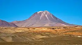
Laguna Verde (volcano)
Cerro Laguna Verde is one of the many stratovolcanoes that integrate a 180 km (112 mi)-long chain east of the Gran Salar de Atacama in Chile's II Region. The mountain is located 6 km (4 mi) west of Acamarachi (also known as Cerro de Pili) and 12.5 km (8 mi) north of the Aguas Calientes (Simbad) and Lascar stratovolcanoes.
| Cerro Laguna Verde | |
|---|---|
 The Cerro Laguna Verde volcano, seen from Laguna Chaxas. | |
| Highest point | |
| Elevation | 5,464 m (17,927 ft) [1] |
| Coordinates | 23.252°S 67.71°W [1] |
| Geography | |
| Location | Chile |
| Parent range | Andes |
| Geology | |
| Mountain type | Stratovolcano[1] |
| Last eruption | Pleistocene[1] |
The age of the volcano, which rises 1,200 metres (3,900 ft) above the surrounding terrain is not known for certain. Earlier it was considered Pleistocene-Holocene. At some point in the past, the northern flank of the volcano collapsed. The resulting debris avalanche formed a lake in the Quebrada Portor from water dammed by the debris.[1] The edifice has an estimated volume of 16 cubic kilometres (3.8 cu mi).[2]
Footnotes
- "Laguna Verde". Global Volcanism Program. Smithsonian Institution.
- Aravena, Diego; Villalón, Ignacio; Pablo, Sánchez. "Igneous Related Geothermal Resource in the Chilean Andes" (PDF). World Geothermal Congress 2015. Retrieved 10 April 2016.
This article is issued from Wikipedia. The text is licensed under Creative Commons - Attribution - Sharealike. Additional terms may apply for the media files.
