Lake Hopkins
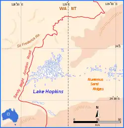
Lake Hopkins is a salt lake in the east of Western Australia very close to the Northern Territory border.[1] It is located to the west of Lake Neale, which together with Lake Amadeus forms part of a chain of salt lakes that stretches about 500 km (310 mi), from Lake Hopkins in the west to the Finke River in the east.[2] This drainage basin is known as the Amadeus Basin.[3] The lake is usually a dry salt pan, and only holds water for short periods after heavy rainfall. Lake Hopkins has an elevation of 441 metres (1447 feet) above mean sea level.[4] The lake proved to be quite an obstacle to progress for Len Beadell during construction of the Sandy Blight Junction Road in 1960.[5]
| Lake Hopkins | |
|---|---|
 | |
 Lake Hopkins | |
| Location | Northern Territory |
| Coordinates | 24°15′S 128°50′E |
| Type | Salt lake |
| Basin countries | Australia |
| Max. length | 42 km (26 mi) |
| Max. width | 35 km (22 mi) |
| Surface elevation | 441 m (1,447 ft) |
References
- World Aeronautical Chart ICAO - 1:1000000 Petermann Ranges (3344) Jan 1972
- A. J. McComb, P. S. Lake (1988). The Conservation of Australian wetlands. World Wildlife Fund Australia. p. 113. ISBN 9780949324139.
- Michael Lazarides (1970). The grasses of Central Australia. Australian National University Press. p. xvi.
- Geoscience Australia elevation data portal
- Beadell, Len (1976). Beating About the Bush. New Holland Publishers(Australia). p. 155. ISBN 1876622156.
External links
This article is issued from Wikipedia. The text is licensed under Creative Commons - Attribution - Sharealike. Additional terms may apply for the media files.
