Lake Madison, South Dakota
Lake Madison is an unincorporated community and census-designated place in Lake County, South Dakota, United States. Its population was 683 as of the 2010 census.[2] The community is located on the shores of Lake Madison.
Lake Madison, South Dakota | |
|---|---|
 Lake Madison  Lake Madison | |
| Coordinates: 43°57′33″N 97°01′15″W | |
| Country | United States |
| State | South Dakota |
| County | Lake |
| Area | |
| • Total | 9.104 sq mi (23.58 km2) |
| • Land | 4.749 sq mi (12.30 km2) |
| • Water | 4.355 sq mi (11.28 km2) |
| Elevation | 1,604 ft (489 m) |
| Population | |
| • Total | 683 |
| • Density | 144.6/sq mi (55.8/km2) |
| Time zone | UTC-6 (Central (CST)) |
| • Summer (DST) | UTC-5 (CDT) |
| Area code(s) | 605 |
| GNIS feature ID | 2584557[3] |
| FIPS code | 46-35430 |
Geography
The community is in southeastern Lake County, surrounding Lake Madison. The CDP is 3 to 10 miles (5 to 16 km) southeast of Madison, the county seat. South Dakota Highway 34 forms the northern edge of the CDP. The highway leads west into Madison and east 13 miles (21 km) to Interstate 29.
According to the U.S. Census Bureau, the community has an area of 9.104 square miles (23.58 km2); 4.749 square miles (12.30 km2) of its area is land, and 4.355 square miles (11.28 km2) is water.[1] Lake Madison drains to the southeast, into Round Lake and then Brant Lake, and is part of the Big Sioux River watershed.
References
- "2019 U.S. Gazetteer Files". United States Census Bureau. Retrieved December 30, 2020.
- "Total Population: 2010 Census DEC Summary File 1 (P1), Lake Madison CDP, South Dakota". data.census.gov. U.S. Census Bureau. Retrieved December 30, 2020.
- "Lake Madison Census Designated Place". Geographic Names Information System. United States Geological Survey.
Municipalities and communities of Lake County, South Dakota, United States | ||
|---|---|---|
| City | 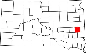 | |
| Towns | ||
| Village | ||
| CDPs | ||
| Other unincorporated communities | ||
| ||